TopoQuest Logo
Do you find TopoQuest useful?
Help keep TopoQuest running and adding new maps/features by donating!
Bitcoin:  19c7KJd3qBynnjoSw5npx9KScwjBe4ifkT
Litecoin:  LXs6TkuXGGXo1vDsWCkWVdjQX94eUKd6ui
Home View Maps Find Maps Find Places Resources & Links


Union City, Michigan Topographic Map

USGS Map Title: Union City, MI
USGS Map MRC: 42085A2
DRG (GeoTIFF) Download: o42085a2.tif


Neighboring USGS Topographic Map Quads:


  Climax, MI  
42085B3
 

  East Leroy, MI  
42085B2
 

  Ellis Corners, MI  
42085B1
 

  Leonidas, MI  
42085A3
 

  Union City, MI  
42085A2
 

  Burlington, MI  
42085A1
 

  Colon, MI  
41085H3
 

  Bronson North, MI  
41085H2
 

  Coldwater West, MI  
41085H1


Map MRC Location:

N43°
W86°
N43°
W85°
H8 H7 H6 H5 H4 H3 H2 H1
G8 G7 G6 G5 G4 G3 G2 G1
F8 F7 F6 F5 F4 F3 F2 F1
E8 E7 E6 E5 E4 E3 E2 E1
D8 D7 D6 D5 D4 D3 D2 D1
C8 C7 C6 C5 C4 C3 C2 C1
B8 B7 B6 B5 B4 B3 B2 B1
A8 A7 A6 A5 A4 A3 A2 A1
N42°
W86°
N42°
W85°

Union City, MI USGS 1:24K Topographic Map Preview:
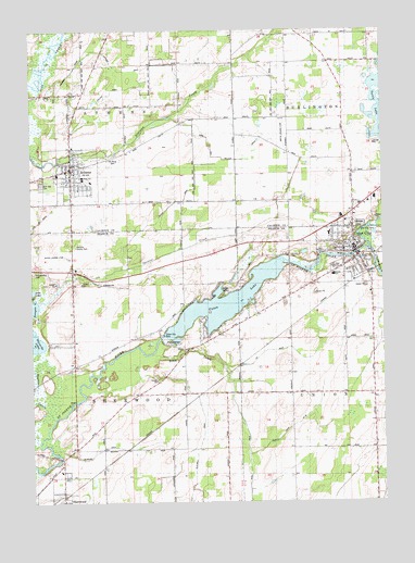
Union City, MI USGS Topographic Map
Click on map above to begin viewing in our Map Viewer.

This topographic map contains these locations and features:
Feature Name Type Latitude Longitude GNIS ID View Map
Assembly of God ChurchChurchN42.0672°W85.1506°2435316View Map
AthensPopulated PlaceN42.0887°W85.2347°620296View Map
Athens Christian ChurchChurchN42.0872°W85.2342°2630117View Map
Athens Community LibraryBuildingN42.0883°W85.2347°2630111View Map
Athens High SchoolSchoolN42.0861°W85.2314°2630109View Map
Athens Middle SchoolSchoolN42.0850°W85.2286°2630110View Map
Athens Post OfficePost OfficeN42.0886°W85.2358°2630113View Map
Athens Station (historical)LocaleN42.0878°W85.2403°2630108View Map
Athens Township Fire DepartmentBuildingN42.0883°W85.2348°2630112View Map
Athens United Methodist ChurchChurchN42.0889°W85.2372°2630114View Map
Blackwell DrainCanalN42.0217°W85.1889°2109263View Map
Brick SchoolSchoolN42.0612°W85.2344°621955View Map
Buell DrainCanalN42.0181°W85.1736°2109260View Map
Burnett CreekStreamN42.0723°W85.1269°622290View Map
Burr Oak CemeteryCemeteryN42.0845°W85.2461°622317View Map
Coldwater RiverStreamN42.0639°W85.1369°623572View Map
Congregational ChurchChurchN42.0878°W85.2372°2630116View Map
County Drain Number Fifty-EightCanalN42.0200°W85.1578°2109261View Map
David's Airport (historical)AirportN42.0651°W85.2398°1623783View Map
First Congregational ChurchChurchN42.0689°W85.1350°2435313View Map
Histand DrainCanalN42.1167°W85.2208°2109305View Map
Hitchcock Post Office (historical)Post OfficeN42.0228°W85.1392°2463621View Map
Home SchoolSchoolN42.1000°W85.1975°628507View Map
Keeler General Baptist ChurchChurchN42.1111°W85.1703°2574831View Map
Keeler United Methodist ChurchChurchN42.1142°W85.1625°2574832View Map
Kendig DrainCanalN42.0775°W85.2022°2109300View Map
Kilbourn DrainCanalN42.0144°W85.2236°2109264View Map
Lee DrainCanalN42.0403°W85.1667°2109262View Map
Leonard SchoolSchoolN42.0945°W85.1353°630317View Map
Lincoln SchoolSchoolN42.0287°W85.1575°630846View Map
Little BridgeBridgeN42.0267°W85.2339°1623489View Map
North Sherwood CemeteryCemeteryN42.0612°W85.2480°633650View Map
Old Burg CemeteryCemeteryN42.0917°W85.2208°2109303View Map
Our Lady of Fatima ChurchChurchN42.0769°W85.1356°2420844View Map
Our Savior Lutheran ChurchChurchN42.0619°W85.1397°2435315View Map
Riley CreekStreamN42.0389°W85.2066°635932View Map
Riverside CemeteryCemeteryN42.0733°W85.1328°2109299View Map
Rowe and Wallace DrainCanalN42.0917°W85.1844°2109302View Map
Selas ParkParkN42.0683°W85.1322°2435415View Map
Selby SchoolSchoolN42.0373°W85.2291°637562View Map
SherwoodPopulated PlaceN42.0014°W85.2386°637777View Map
Sherwood CemeteryCemeteryN42.0067°W85.2386°2435449View Map
Sherwood LibraryBuildingN42.0003°W85.2375°2435325View Map
Sherwood Post OfficePost OfficeN42.0003°W85.2397°2435323View Map
Sherwood Station (historical)LocaleN42.0011°W85.2392°2435326View Map
Sherwood Township Fire DepartmentBuildingN42.0059°W85.2388°2636040View Map
Sherwood Township HallBuildingN42.0053°W85.2394°2435324View Map
Smith SchoolSchoolN42.0284°W85.1961°638170View Map
Smiths Landing Strip (historical)AirportN42.0981°W85.1597°2109301View Map
South Histand DrainCanalN42.1061°W85.2267°2109304View Map
Spencer CreekStreamN42.0209°W85.2472°638497View Map
Studley BridgeBridgeN42.0117°W85.2397°1623659View Map
Tadmore SchoolSchoolN42.1162°W85.1583°1614534View Map
Township of AthensCivilN42.1155°W85.2359°1625856View Map
Township of SherwoodCivilN42.0285°W85.2347°1627079View Map
Turtle LakeLakeN42.1051°W85.1259°1615207View Map
Tuttle LakeLakeN42.0550°W85.1894°1615216View Map
Union CityPopulated PlaceN42.0667°W85.1361°1615340View Map
Union City DamDamN42.0431°W85.2016°1615341View Map
Union City Fire DepartmentBuildingN42.0680°W85.1341°2435307View Map
Union City Furnace Historical MarkerParkN42.0653°W85.1331°2435417View Map
Union City Medical CenterHospitalN42.0689°W85.1628°2435311View Map
Union City Methodist Episcopal Church Historical MarkerParkN42.0669°W85.1369°2435418View Map
Union City Middle SchoolSchoolN42.0603°W85.1425°2435319View Map
Union City Middle SchoolSchoolN42.0711°W85.1442°2435320View Map
Union City Police DepartmentBuildingN42.0680°W85.1341°2435308View Map
Union City Post OfficePost OfficeN42.0675°W85.1358°2435310View Map
Union City Senior High SchoolSchoolN42.0622°W85.1425°2435318View Map
Union City Station (historical)LocaleN42.0589°W85.1350°2435306View Map
Union City Wesleyan ChurchChurchN42.0642°W85.1353°2435314View Map
Union LakeReservoirN42.0529°W85.1814°1615348View Map
Union Township LibraryBuildingN42.0667°W85.1350°2435309View Map
United Methodist ChurchChurchN42.0672°W85.1369°2435312View Map
Village of AthensCivilN42.0866°W85.2356°2398004View Map
Village of Union CityCivilN42.0664°W85.1430°2400023View Map
Waldron County ParkParkN42.0681°W85.2347°2109265View Map

Note: Coordinates in the location and feature list above are referenced to NAD83 datum.


Copyright (C) 2008-2024 Ryan Niemi / Sunset Dynamics ... All Rights Reserved