TopoQuest Logo
Do you find TopoQuest useful?
Help keep TopoQuest running and adding new maps/features by donating!
Bitcoin:  19c7KJd3qBynnjoSw5npx9KScwjBe4ifkT
Litecoin:  LXs6TkuXGGXo1vDsWCkWVdjQX94eUKd6ui
Home View Maps Find Maps Find Places Resources & Links


Upheaval Dome, Utah Topographic Map

USGS Map Title: Upheaval Dome, UT
USGS Map MRC: 38109D8
DRG (GeoTIFF) Download: o38109d8.tif


Neighboring USGS Topographic Map Quads:


  Bowknot Bend, UT  
38110E1
 

  Mineral Canyon, UT  
38109E8
 

  The Knoll, UT  
38109E7
 

  Horsethief Canyon, UT  
38110D1
 

  Upheaval Dome, UT  
38109D8
 

  Musselman Arch, UT  
38109D7
 

  Cleopatras Chair, UT  
38110C1
 

  Turks Head, UT  
38109C8
 

  Monument Basin, UT  
38109C7


Map MRC Location:

N39°
W110°
N39°
W109°
H8 H7 H6 H5 H4 H3 H2 H1
G8 G7 G6 G5 G4 G3 G2 G1
F8 F7 F6 F5 F4 F3 F2 F1
E8 E7 E6 E5 E4 E3 E2 E1
D8 D7 D6 D5 D4 D3 D2 D1
C8 C7 C6 C5 C4 C3 C2 C1
B8 B7 B6 B5 B4 B3 B2 B1
A8 A7 A6 A5 A4 A3 A2 A1
N38°
W110°
N38°
W109°

Upheaval Dome, UT USGS 1:24K Topographic Map Preview:
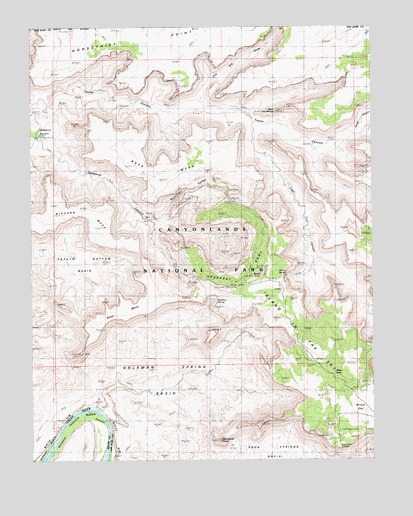
Upheaval Dome, UT USGS Topographic Map
Click on map above to begin viewing in our Map Viewer.

This topographic map contains these locations and features:
Feature Name Type Latitude Longitude GNIS ID View Map
Alcove SpringSpringN38.4291°W109.9073°1434914View Map
Bighorn MesaSummitN38.4422°W109.9741°1434911View Map
Buck MesaSummitN38.4553°W109.9523°1426053View Map
Candlestick TowerPillarN38.3811°W109.9318°1434912View Map
Candlestick TowerSummitN38.3805°W109.9321°1450279View Map
Green River OverlookLocaleN38.3783°W109.8885°1434913View Map
Holeman CanyonValleyN38.3881°W109.9742°1435687View Map
Holeman SpringSpringN38.4200°W109.9301°1428775View Map
Holeman Spring BasinBasinN38.3975°W109.9468°1428776View Map
Island in the SkyPlainN38.3972°W109.8896°1454623View Map
Mulley PointCapeN38.4672°W109.9710°1436009View Map
Potato Bottom BasinBasinN38.4322°W109.9810°1431438View Map
Rough CanyonValleyN38.4703°W109.8805°1432013View Map
Steer MesaSummitN38.4121°W109.9760°1432951View Map
Syncline ValleyValleyN38.4444°W109.9544°1434969View Map
Taylor CanyonValleyN38.4761°W109.9931°1433198View Map
The Big DrawValleyN38.4782°W109.9388°1433264View Map
The BreachGapN38.4511°W109.9285°1435188View Map
Trail CanyonValleyN38.4724°W109.9190°1433634View Map
Upheaval BottomBendN38.4675°W109.9971°1433791View Map
Upheaval CanyonValleyN38.4662°W109.9935°1433792View Map
Upheaval DomeSummitN38.4245°W109.9293°1433793View Map
Upheaval Dome TrailTrailN38.4500°W109.9646°1436554View Map
Valentine BottomBendN38.3872°W109.9807°1433858View Map
Whale RockPillarN38.4283°W109.9173°1434915View Map
Willow FlatFlatN38.3858°W109.8829°1434325View Map
Willow Flat CampgroundLocaleN38.3950°W109.8996°1436649View Map
Willow SeepSpringN38.3994°W109.8894°1434333View Map
Zeus and MosesPillarN38.4755°W109.9107°1434916View Map

Note: Coordinates in the location and feature list above are referenced to NAD83 datum.


Copyright (C) 2008-2025 Ryan Niemi / Sunset Dynamics ... All Rights Reserved