TopoQuest Logo
Do you find TopoQuest useful?
Help keep TopoQuest running and adding new maps/features by donating!
Bitcoin:  19c7KJd3qBynnjoSw5npx9KScwjBe4ifkT
Litecoin:  LXs6TkuXGGXo1vDsWCkWVdjQX94eUKd6ui
Home View Maps Find Maps Find Places Resources & Links


Valera, Texas Topographic Map

USGS Map Title: Valera, TX
USGS Map MRC: 31099G5
DRG (GeoTIFF) Download: o31099g5.tif


Neighboring USGS Topographic Map Quads:


  Novice West, TX  
31099H6
 

  Novice East, TX  
31099H5
 

  Lake Scarborough, TX  
31099H4
 

  Talpa, TX  
31099G6
 

  Valera, TX  
31099G5
 

  Coleman, TX  
31099G4
 

  Little Grape Creek, TX  
31099F6
 

  Bead Mountain, TX  
31099F5
 

  Fisk, TX  
31099F4


Map MRC Location:

N32°
W100°
N32°
W99°
H8 H7 H6 H5 H4 H3 H2 H1
G8 G7 G6 G5 G4 G3 G2 G1
F8 F7 F6 F5 F4 F3 F2 F1
E8 E7 E6 E5 E4 E3 E2 E1
D8 D7 D6 D5 D4 D3 D2 D1
C8 C7 C6 C5 C4 C3 C2 C1
B8 B7 B6 B5 B4 B3 B2 B1
A8 A7 A6 A5 A4 A3 A2 A1
N31°
W100°
N31°
W99°

Valera, TX USGS 1:24K Topographic Map Preview:
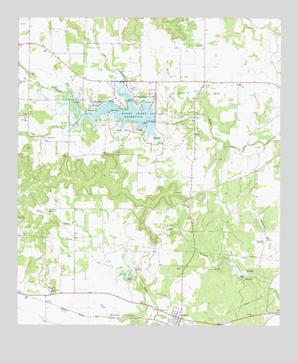
Valera, TX USGS Topographic Map
Click on map above to begin viewing in our Map Viewer.

This topographic map contains these locations and features:
Feature Name Type Latitude Longitude GNIS ID View Map
Bead Mountain CreekStreamN31.7546°W99.5584°1330188View Map
Centennial SchoolSchoolN31.7988°W99.5440°1332519View Map
Flat Rock ParkParkN31.8296°W99.5709°1335921View Map
Friendship ParkParkN31.8429°W99.5631°1336248View Map
Hords Creek DamDamN31.8501°W99.5670°1854262View Map
Hords Creek LakeReservoirN31.8360°W99.5737°1338084View Map
Lakeside ParkParkN31.8415°W99.5853°1339539View Map
Live Oak BranchStreamN31.8465°W99.5759°1374621View Map
McCall BranchStreamN31.8329°W99.5478°1341140View Map
Old Valera CemeteryCemeteryN31.7621°W99.5534°1343241View Map
Post Oak SpringSpringN31.7961°W99.6105°1344415View Map
Soil Conservation Service Site 2 DamDamN31.7685°W99.5720°1858601View Map
Soil Conservation Service Site 2 ReservoirReservoirN31.7707°W99.5728°1858602View Map
Soil Conservation Service Site 3 DamDamN31.7701°W99.5170°1858599View Map
Soil Conservation Service Site 3 ReservoirReservoirN31.7714°W99.5194°1858600View Map
Soil Conservation Service Site 36 DamDamN31.8718°W99.5170°1858595View Map
Soil Conservation Service Site 36 ReservoirReservoirN31.8706°W99.5190°1858596View Map
Soil Conservation Service Site 4 DamDamN31.7851°W99.5053°1858597View Map
Soil Conservation Service Site 4 ReservoirReservoirN31.7860°W99.5067°1858598View Map
Turtle Neck CreekStreamN31.8351°W99.5951°1348929View Map
ValeraPopulated PlaceN31.7529°W99.5473°1349152View Map
Valera Post OfficePost OfficeN31.7532°W99.5472°2731982View Map
Warner Oil FieldOilfieldN31.7821°W99.5556°1349493View Map

Note: Coordinates in the location and feature list above are referenced to NAD83 datum.


Copyright (C) 2008-2025 Ryan Niemi / Sunset Dynamics ... All Rights Reserved