TopoQuest Logo
Do you find TopoQuest useful?
Help keep TopoQuest running and adding new maps/features by donating!
Bitcoin:  19c7KJd3qBynnjoSw5npx9KScwjBe4ifkT
Litecoin:  LXs6TkuXGGXo1vDsWCkWVdjQX94eUKd6ui
Home View Maps Find Maps Find Places Resources & Links


Van Vleck, Texas Topographic Map

USGS Map Title: Van Vleck, TX
USGS Map MRC: 29095A8
DRG (GeoTIFF) Download: o29095a8.tif


Neighboring USGS Topographic Map Quads:


  Lane City, TX  
29096B1
 

  Pledger, TX  
29095B8
 

  Danciger, TX  
29095B7
 

  Lane City SE, TX  
29096A1
 

  Van Vleck, TX  
29095A8
 

  Ashwood, TX  
29095A7
 

  Markham, TX  
28096H1
 

  Bay City, TX  
28095H8
 

  Bay City NE, TX  
28095H7


Map MRC Location:

N30°
W96°
N30°
W95°
H8 H7 H6 H5 H4 H3 H2 H1
G8 G7 G6 G5 G4 G3 G2 G1
F8 F7 F6 F5 F4 F3 F2 F1
E8 E7 E6 E5 E4 E3 E2 E1
D8 D7 D6 D5 D4 D3 D2 D1
C8 C7 C6 C5 C4 C3 C2 C1
B8 B7 B6 B5 B4 B3 B2 B1
A8 A7 A6 A5 A4 A3 A2 A1
N29°
W96°
N29°
W95°

Van Vleck, TX USGS 1:24K Topographic Map Preview:
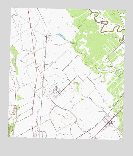
Van Vleck, TX USGS Topographic Map
Click on map above to begin viewing in our Map Viewer.

This topographic map contains these locations and features:
Feature Name Type Latitude Longitude GNIS ID View Map
Ag Aviation Airport (historical)AirportN29.0541°W95.9625°1386207View Map
Armour Oil FieldOilfieldN29.0830°W95.9811°1351256View Map
Bay City DivisionCivilN29.0218°W95.8959°1938519View Map
Bay City Oil FieldOilfieldN29.0466°W95.9469°1351613View Map
Camp PierceLocaleN29.0928°W95.9330°1353659View Map
ChalmersPopulated PlaceN29.0711°W95.9616°1379528View Map
Free System CemeteryCemeteryN29.0311°W95.8761°1357709View Map
Matagorda County Alternative Education SchoolSchoolN29.0159°W95.8887°2434547View Map
McCroskeyPopulated PlaceN29.0994°W95.9597°1380166View Map
O H Herman Middle SchoolSchoolN29.0266°W95.8955°2007646View Map
PodoPopulated PlaceN29.1125°W95.9011°1380384View Map
Van VleckPopulated PlaceN29.0178°W95.8894°1370579View Map
Van Vleck Census Designated PlaceCensusN29.0275°W95.8803°2409500View Map
Van Vleck Elementary SchoolSchoolN29.0164°W95.8890°2007652View Map
Van Vleck High SchoolSchoolN29.0170°W95.8875°2007653View Map
Van Vleck High SchoolSchoolN29.0269°W95.8958°1370580View Map
Van Vleck Intermediate SchoolSchoolN29.0162°W95.8892°2007744View Map
Van Vleck Post OfficePost OfficeN29.0187°W95.8897°2731508View Map
Van Vleck Volunteer Fire DepartmentBuildingN29.0173°W95.8926°2334608View Map

Note: Coordinates in the location and feature list above are referenced to NAD83 datum.


Copyright (C) 2008-2025 Ryan Niemi / Sunset Dynamics ... All Rights Reserved