TopoQuest Logo
Do you find TopoQuest useful?
Help keep TopoQuest running and adding new maps/features by donating!
Bitcoin:  19c7KJd3qBynnjoSw5npx9KScwjBe4ifkT
Litecoin:  LXs6TkuXGGXo1vDsWCkWVdjQX94eUKd6ui
Home View Maps Find Maps Find Places Resources & Links


Variadero, New Mexico Topographic Map

USGS Map Title: Variadero, NM
USGS Map MRC: 35104D4
DRG (GeoTIFF) Download: o35104d4.tif


Neighboring USGS Topographic Map Quads:


  Canon Olguin, NM  
35104E5
 

  San Ramon, NM  
35104E4
 

  Wade Canyon, NM  
35104E3
 

  Cerro De Corazon, NM  
35104D5
 

  Variadero, NM  
35104D4
 

  Four V Ranch, NM  
35104D3
 

  Mesa Pino, NM  
35104C5
 

  La Silla, NM  
35104C4
 

  Bookout Ranch, NM  
35104C3


Map MRC Location:

N36°
W105°
N36°
W104°
H8 H7 H6 H5 H4 H3 H2 H1
G8 G7 G6 G5 G4 G3 G2 G1
F8 F7 F6 F5 F4 F3 F2 F1
E8 E7 E6 E5 E4 E3 E2 E1
D8 D7 D6 D5 D4 D3 D2 D1
C8 C7 C6 C5 C4 C3 C2 C1
B8 B7 B6 B5 B4 B3 B2 B1
A8 A7 A6 A5 A4 A3 A2 A1
N35°
W105°
N35°
W104°

Variadero, NM USGS 1:24K Topographic Map Preview:
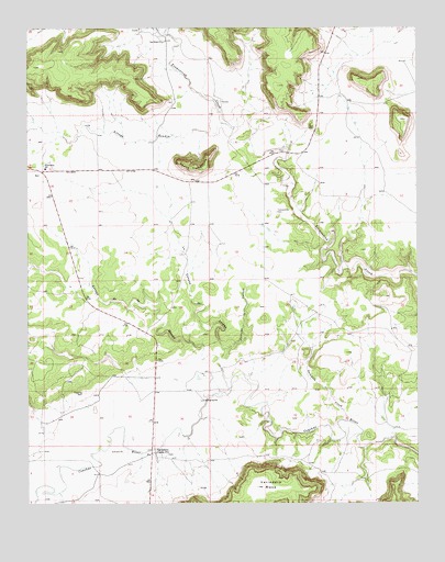
Variadero, NM USGS Topographic Map
Click on map above to begin viewing in our Map Viewer.

This topographic map contains these locations and features:
Feature Name Type Latitude Longitude GNIS ID View Map
Arroyo HondoStreamN35.4981°W104.4544°897642View Map
Arroyo MangaStreamN35.4053°W104.4350°897577View Map
Arroyo RendiaStreamN35.4748°W104.4378°897667View Map
Caņada la CalosaValleyN35.4156°W104.4364°897713View Map
GonzalesLocaleN35.4828°W104.4375°924493View Map
La Canada del SaladoValleyN35.4167°W104.4380°890778View Map
Mesita TrementinaSummitN35.4639°W104.4503°899791View Map
New TrementinaPopulated PlaceN35.4639°W104.4944°924431View Map
NickLocaleN35.4428°W104.4514°924505View Map
Saladito CreekStreamN35.3967°W104.3978°894301View Map
San Miguel County Fire District Trementina Fire DepartmentBuildingN35.4627°W104.4952°2657868View Map
San RafaelPopulated PlaceN35.4920°W104.4564°924504View Map
San Rafael ChurchChurchN35.4962°W104.4564°894478View Map
Trementina CemeteryCemeteryN35.4517°W104.4206°895814View Map
Trementina SchoolSchoolN35.4631°W104.4947°895816View Map
VariaderoPopulated PlaceN35.3881°W104.4594°896104View Map

Note: Coordinates in the location and feature list above are referenced to NAD83 datum.


Copyright (C) 2008-2024 Ryan Niemi / Sunset Dynamics ... All Rights Reserved