TopoQuest Logo
Do you find TopoQuest useful?
Help keep TopoQuest running and adding new maps/features by donating!
Bitcoin:  19c7KJd3qBynnjoSw5npx9KScwjBe4ifkT
Litecoin:  LXs6TkuXGGXo1vDsWCkWVdjQX94eUKd6ui
Home View Maps Find Maps Find Places Resources & Links


Verhelle, Texas Topographic Map

USGS Map Title: Verhelle, TX
USGS Map MRC: 29097A2
DRG (GeoTIFF) Download: o29097a2.tif


Neighboring USGS Topographic Map Quads:


  Concrete, TX  
29097B3
 

  Edgar, TX  
29097B2
 

  Terryville, TX  
29097B1
 

  Cuero, TX  
29097A3
 

  Verhelle, TX  
29097A2
 

  Fordtran, TX  
29097A1
 

  Meyersville, TX  
28097H3
 

  Mission Valley, TX  
28097H2
 

  Nursery, TX  
28097H1


Map MRC Location:

N30°
W98°
N30°
W97°
H8 H7 H6 H5 H4 H3 H2 H1
G8 G7 G6 G5 G4 G3 G2 G1
F8 F7 F6 F5 F4 F3 F2 F1
E8 E7 E6 E5 E4 E3 E2 E1
D8 D7 D6 D5 D4 D3 D2 D1
C8 C7 C6 C5 C4 C3 C2 C1
B8 B7 B6 B5 B4 B3 B2 B1
A8 A7 A6 A5 A4 A3 A2 A1
N29°
W98°
N29°
W97°

Verhelle, TX USGS 1:24K Topographic Map Preview:
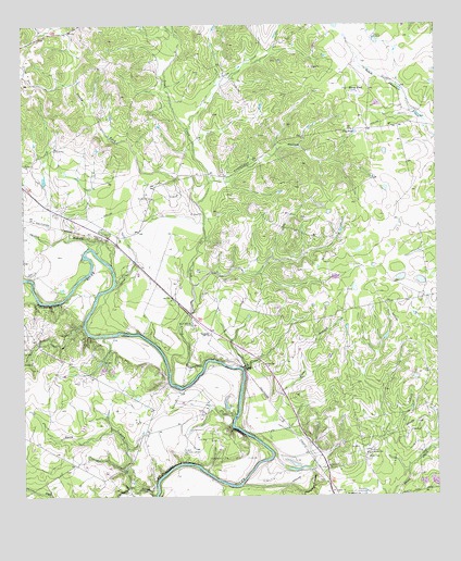
Verhelle, TX USGS Topographic Map
Click on map above to begin viewing in our Map Viewer.

This topographic map contains these locations and features:
Feature Name Type Latitude Longitude GNIS ID View Map
Berry PondLakeN29.1076°W97.1497°1377514View Map
Burns Station CemeteryCemeteryN29.0461°W97.1989°1377526View Map
Carlisle CreekStreamN29.0008°W97.2103°1377530View Map
Cattail CreekStreamN29.0455°W97.2317°1377532View Map
Crittendon HollowValleyN29.0839°W97.1925°1377542View Map
Cuero DivisionCivilN29.0942°W97.1910°1938663View Map
Flag PondReservoirN29.0968°W97.1497°1377554View Map
Irish CreekStreamN29.0350°W97.1953°1377571View Map
Jennie Bell Oil FieldOilfieldN29.0164°W97.1319°1377573View Map
KQRO-AM (Cuero)TowerN29.0739°W97.2392°1385539View Map
KQRO-FM (Cuero)TowerN29.0739°W97.2392°1385833View Map
Mount Bethany ChurchChurchN29.0008°W97.1533°1377597View Map
North Carlisle CreekStreamN29.0030°W97.2186°1377606View Map
Oaxley BranchStreamN29.0650°W97.2280°1377686View Map
Ponteon San Isidro Labrador CemeteryCemeteryN29.0122°W97.2019°1377610View Map
Reeds BranchStreamN29.0030°W97.1847°1377616View Map
Sandy ForkStreamN29.0778°W97.1964°1377633View Map
Taylor CemeteryCemeteryN29.0594°W97.2489°1377642View Map
Thomas WindmillLocaleN29.1216°W97.1433°1377647View Map
Thomaston Community CemeteryCemeteryN29.0014°W97.1503°1377649View Map
Thomaston Compressor StationLocaleN29.0114°W97.1464°1384697View Map
Thomaston Oil FieldOilfieldN29.0116°W97.1869°1377651View Map
VerhellePopulated PlaceN29.0441°W97.1930°1380718View Map
Verhelle Oil FieldOilfieldN29.0316°W97.2025°1377656View Map

Note: Coordinates in the location and feature list above are referenced to NAD83 datum.


Copyright (C) 2008-2025 Ryan Niemi / Sunset Dynamics ... All Rights Reserved