TopoQuest Logo
Do you find TopoQuest useful?
Help keep TopoQuest running and adding new maps/features by donating!
Bitcoin:  19c7KJd3qBynnjoSw5npx9KScwjBe4ifkT
Litecoin:  LXs6TkuXGGXo1vDsWCkWVdjQX94eUKd6ui
Home View Maps Find Maps Find Places Resources & Links


Vevay North, Indiana Topographic Map

USGS Map Title: Vevay North, IN
USGS Map MRC: 38085G1
DRG (GeoTIFF) Download: o38085g1.tif


Neighboring USGS Topographic Map Quads:


  Cross Plains, IN  
38085H2
 

  Bear Branch, IN  
38085H1
 

  Aberdeen, IN  
38084H8
 

  Bennington, IN  
38085G2
 

  Vevay North, IN  
38085G1
 

  Florence, IN  
38084G8
 

  Carrollton, KY  
38085F2
 

  Vevay South, IN  
38085F1
 

  Sanders, KY  
38084F8


Map MRC Location:

N39°
W86°
N39°
W85°
H8 H7 H6 H5 H4 H3 H2 H1
G8 G7 G6 G5 G4 G3 G2 G1
F8 F7 F6 F5 F4 F3 F2 F1
E8 E7 E6 E5 E4 E3 E2 E1
D8 D7 D6 D5 D4 D3 D2 D1
C8 C7 C6 C5 C4 C3 C2 C1
B8 B7 B6 B5 B4 B3 B2 B1
A8 A7 A6 A5 A4 A3 A2 A1
N38°
W86°
N38°
W85°

Vevay North, IN USGS 1:24K Topographic Map Preview:
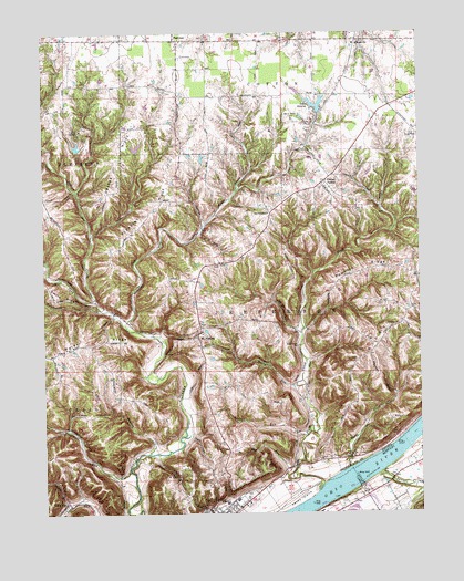
Vevay North, IN USGS Topographic Map
Click on map above to begin viewing in our Map Viewer.

This topographic map contains these locations and features:
Feature Name Type Latitude Longitude GNIS ID View Map
Abes BranchStreamN38.7656°W85.0905°429987View Map
Agniels CreekStreamN38.7601°W85.0141°485795View Map
AllensvillePopulated PlaceN38.8731°W85.0202°430098View Map
Beetree RunStreamN38.7701°W85.0386°430745View Map
Blanton CemeteryCemeteryN38.7526°W85.0255°1901025View Map
Broad RunStreamN38.7831°W85.0411°431546View Map
Camp LivingstonParkN38.8501°W85.1127°432043View Map
Camp Livingston LakeReservoirN38.8456°W85.1137°448510View Map
Camp Livingston Lake DamDamN38.8451°W85.1150°448511View Map
Center SquarePopulated PlaceN38.8364°W85.0313°449635View Map
Drakes RidgeRidgeN38.8423°W85.1008°433683View Map
Edwin Pray LakeReservoirN38.8453°W85.0935°447819View Map
Edwin Pray Lake DamDamN38.8451°W85.0933°447818View Map
FairviewPopulated PlaceN38.8734°W85.0808°449654View Map
Fredonia ChurchChurchN38.7990°W85.0069°434795View Map
Halls BranchStreamN38.7531°W85.1175°435620View Map
Hog RunStreamN38.7615°W85.0424°436292View Map
Hunt CreekStreamN38.7620°W85.0238°436615View Map
JacksonvillePopulated PlaceN38.8289°W85.0488°436905View Map
Jefferson Craig Volunteer Fire DepartmentBuildingN38.7509°W85.0702°2625553View Map
Kentucky Utilities Power PlantBuildingN38.7543°W85.0213°2565023View Map
Lake GenevaReservoirN38.8559°W85.0343°435015View Map
Lake Geneva DamDamN38.8534°W85.0333°447817View Map
Long RunPopulated PlaceN38.7531°W85.1177°449689View Map
Long RunStreamN38.7501°W85.0975°438283View Map
Mount SterlingPopulated PlaceN38.7959°W85.0738°439699View Map
Parks RidgeRidgeN38.7959°W85.1083°446875View Map
Pendleton RunStreamN38.7615°W85.0972°440990View Map
Pleasant RidgeRidgeN38.8287°W85.0888°441294View Map
Plum CreekStreamN38.7576°W85.0330°441362View Map
Plum Creek ChurchChurchN38.7937°W85.0411°441367View Map
Popcorn RidgeRidgeN38.8128°W85.0194°441437View Map
Roberts AirportAirportN38.8153°W85.1018°2676911View Map
Stow CemeteryCemeteryN38.8478°W85.0002°444250View Map
Switzerland CountyCivilN38.8262°W85.0370°450392View Map
Switzerland County Elementary SchoolSchoolN38.8723°W85.0208°447086View Map
Switzerland County Emergency Medical ServicesBuildingN38.7533°W85.0567°2719364View Map
Tapps RidgeRidgeN38.7859°W85.0236°444576View Map
Township of CottonCivilN38.8730°W85.0157°453248View Map
Township of JeffersonCivilN38.7977°W85.0490°453499View Map
Tumblebug CreekStreamN38.8031°W85.1058°444949View Map
Upper Indian CreekStreamN38.7984°W85.0977°445166View Map
Vevay IslandIslandN38.7528°W85.0399°506032View Map
WAVV-FM (Vevay)TowerN38.8367°W85.0300°448953View Map
West Fork Indian CreekStreamN38.8051°W85.1077°445750View Map
White Water CampParkN38.8526°W85.0419°445965View Map

Note: Coordinates in the location and feature list above are referenced to NAD83 datum.


Copyright (C) 2008-2025 Ryan Niemi / Sunset Dynamics ... All Rights Reserved