TopoQuest Logo
Do you find TopoQuest useful?
Help keep TopoQuest running and adding new maps/features by donating!
Bitcoin:  19c7KJd3qBynnjoSw5npx9KScwjBe4ifkT
Litecoin:  LXs6TkuXGGXo1vDsWCkWVdjQX94eUKd6ui
Home View Maps Find Maps Find Places Resources & Links


Virginia City, Montana Topographic Map

USGS Map Title: Virginia City, MT
USGS Map MRC: 45111C8
DRG (GeoTIFF) Download: o45111c8.tif


Neighboring USGS Topographic Map Quads:


  Copper Mountain, MT  
45112D1
 

  Ramshorn Mountain, MT  
45111D8
 

  Leonard Creek, MT  
45111D7
 

  Alder, MT  
45112C1
 

  Virginia City, MT  
45111C8
 

  Eightmile Creek, MT  
45111C7
 

  Ruby Dam, MT  
45112B1
 

  Cirque Lake, MT  
45111B8
 

  Varney, MT  
45111B7


Map MRC Location:

N46°
W112°
N46°
W111°
H8 H7 H6 H5 H4 H3 H2 H1
G8 G7 G6 G5 G4 G3 G2 G1
F8 F7 F6 F5 F4 F3 F2 F1
E8 E7 E6 E5 E4 E3 E2 E1
D8 D7 D6 D5 D4 D3 D2 D1
C8 C7 C6 C5 C4 C3 C2 C1
B8 B7 B6 B5 B4 B3 B2 B1
A8 A7 A6 A5 A4 A3 A2 A1
N45°
W112°
N45°
W111°

Virginia City, MT USGS 1:24K Topographic Map Preview:
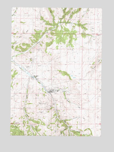
Virginia City, MT USGS Topographic Map
Click on map above to begin viewing in our Map Viewer.

This topographic map contains these locations and features:
Feature Name Type Latitude Longitude GNIS ID View Map
Adobe (historical)Populated PlaceN45.3180°W111.9830°799033View Map
Adobetown Historical MarkerParkN45.3180°W111.9841°1797800View Map
Adobetown Post Office (historical)Post OfficeN45.3180°W111.9830°1797585View Map
Adobetown School (historical)SchoolN45.3180°W111.9830°1797586View Map
Alameda MineMineN45.2819°W111.9516°804253View Map
Alameda MineMineN45.2816°W111.9586°768148View Map
Alder Gulch Short Line Steam Railroad MuseumBuildingN45.3069°W111.9675°1797617View Map
Bamboo Chief MineMineN45.2680°W111.9519°804254View Map
Bell MineMineN45.2699°W111.9366°806755View Map
Belle MineMineN45.2669°W111.9344°804217View Map
Black Rock MineMineN45.2671°W111.9514°804242View Map
Black Rock MineMineN45.2724°W111.9569°768980View Map
Boothill CemeteryCemeteryN45.2949°W111.9486°769103View Map
Browns GulchValleyN45.3066°W111.9753°780462View Map
Butcher GulchValleyN45.2546°W111.9191°793692View Map
Cabin MineMineN45.2791°W111.9355°804251View Map
Camp Cummings (historical)MilitaryN45.2939°W111.9453°1797560View Map
Central City (historical)Populated PlaceN45.3013°W111.9564°1797559View Map
Cornucopia MineMineN45.2794°W111.9464°770094View Map
Cornucopia MineMineN45.2791°W111.9466°804250View Map
Daylight CreekStreamN45.2924°W111.9511°768422View Map
Don-A-Vera/Jayhill MineMineN45.2674°W111.9347°804216View Map
East Fork Granite CreekStreamN45.3599°W111.9350°782848View Map
East Mapleton MineMineN45.3249°W111.9703°804287View Map
El Fleeda MineMineN45.2674°W111.9508°804249View Map
El Fleeda MineMineN45.2758°W111.9511°806774View Map
Gibbs CreekStreamN45.3680°W111.9272°783920View Map
Herman GulchValleyN45.3152°W111.9811°772351View Map
Highland (historical)LocaleN45.2505°W111.9175°1797518View Map
Highland Chief MineMineN45.2513°W111.9689°804248View Map
Highland MineMineN45.2502°W111.9178°804219View Map
Hungry HollowValleyN45.2580°W111.9214°785161View Map
J Spencer Watkins Memorial MuseumBuildingN45.2930°W111.9466°1797621View Map
JunctionPopulated PlaceN45.3235°W111.9972°1797505View Map
Junction Post Office (historical)Post OfficeN45.3235°W111.9972°1797504View Map
Kakoosta MineMineN45.2680°W111.9511°804252View Map
Linder GulchValleyN45.2658°W111.9436°793706View Map
Lucky Strike MineMineN45.2749°W111.9855°804288View Map
Madison CountyCivilN45.3007°W111.9203°1720033View Map
Madison County CourthouseBuildingN45.2933°W111.9447°1797622View Map
Madison County Sheriff's OfficeBuildingN45.2933°W111.9443°1797440View Map
Mapleton MineMineN45.3263°W111.9719°773874View Map
Mill GulchValleyN45.3585°W111.9430°787385View Map
Miller Number 1 MineMineN45.2669°W111.9633°804244View Map
Mountain Chief MineMineN45.2652°W111.9953°804257View Map
Mountain Chief MineMineN45.2621°W111.9958°774425View Map
Mountain Flower MineMineN45.2610°W111.9925°804615View Map
NE Section 4 MineMineN45.2596°W111.9716°804238View Map
Nevada CityLocaleN45.3069°W111.9675°767908View Map
Nevada City CemeteryCemeteryN45.3108°W111.9697°1797660View Map
Nevada City Historical MarkerParkN45.3077°W111.9703°1797801View Map
Nevada City MuseumBuildingN45.3069°W111.9675°1797618View Map
Nevada City School (historical)SchoolN45.3069°W111.9675°1797584View Map
New Gold Bar MineMineN45.2513°W111.9689°804124View Map
NW Section 29 MineMineN45.2888°W111.9953°804261View Map
Pine Grove (historical)LocaleN45.2902°W111.9425°1797469View Map
Prospect MineMineN45.2833°W111.9633°804255View Map
Prospect MineMineN45.2899°W111.9641°775471View Map
Ranks Drug Store MuseumBuildingN45.2930°W111.9464°1797620View Map
Saint Marys Hospital (historical)HospitalN45.2938°W111.9461°1797445View Map
Saint Paul Episcopal ChurchChurchN45.2927°W111.9436°1797446View Map
SW Section 26 MineMineN45.2680°W111.9347°804215View Map
SW Section 28 MineMineN45.2819°W111.9814°804282View Map
SW Section 33 MineMineN45.2666°W111.9686°804241View Map
Teresa MineMineN45.2666°W111.9716°804245View Map
Thompson-Hickman County LibraryBuildingN45.2938°W111.9461°1797610View Map
Thompson-Hickman MuseumBuildingN45.2938°W111.9416°1797619View Map
Threemile CreekStreamN45.2649°W111.9275°767912View Map
Town of Virginia CityCivilN45.2962°W111.9369°2413436View Map
U S Grant-Upper MineMineN45.2680°W111.9350°804214View Map
United States Grant MinesMineN45.2816°W111.9433°806818View Map
Virginia CityPopulated PlaceN45.2938°W111.9461°778036View Map
Virginia City CampgroundLocaleN45.2938°W111.9272°1797664View Map
Virginia City CemeteryCemeteryN45.2971°W111.9402°1797659View Map
Virginia City Historical MarkerParkN45.2921°W111.9494°1797802View Map
Virginia City ParkParkN45.2927°W111.9391°1797612View Map
Virginia City Post OfficePost OfficeN45.2935°W111.9460°1797648View Map
Virginia City Rural Fire DepartmentBuildingN45.2940°W111.9405°1797439View Map
Virginia City School (historical)SchoolN45.2938°W111.9461°1797649View Map
Virginia City Volunteer Fire DepartmentBuildingN45.2934°W111.9447°2637835View Map
West Fork Granite CreekStreamN45.3544°W111.9408°1797625View Map
Wilson-Bell MineMineN45.2666°W111.9347°804218View Map

Note: Coordinates in the location and feature list above are referenced to NAD83 datum.


Copyright (C) 2008-2025 Ryan Niemi / Sunset Dynamics ... All Rights Reserved