TopoQuest Logo
Do you find TopoQuest useful?
Help keep TopoQuest running and adding new maps/features by donating!
Bitcoin:  19c7KJd3qBynnjoSw5npx9KScwjBe4ifkT
Litecoin:  LXs6TkuXGGXo1vDsWCkWVdjQX94eUKd6ui
Home View Maps Find Maps Find Places Resources & Links


Vivian North, Louisiana Topographic Map

USGS Map Title: Vivian North, LA
USGS Map MRC: 32093H8
DRG (GeoTIFF) Download: o32093h8.tif


Neighboring USGS Topographic Map Quads:


  Ravanna, AR  
33094A1
 

  Doddridge, AR  
33093A8
 

  Doddridge SE, AR  
33093A7
 

  McLeod, TX  
32094H1
 

  Vivian North, LA  
32093H8
 

  Wardview, LA  
32093H7
 

  Trees, LA  
32094G1
 

  Vivian South, LA  
32093G8
 

  Gilliam, LA  
32093G7


Map MRC Location:

N33°
W94°
N33°
W93°
H8 H7 H6 H5 H4 H3 H2 H1
G8 G7 G6 G5 G4 G3 G2 G1
F8 F7 F6 F5 F4 F3 F2 F1
E8 E7 E6 E5 E4 E3 E2 E1
D8 D7 D6 D5 D4 D3 D2 D1
C8 C7 C6 C5 C4 C3 C2 C1
B8 B7 B6 B5 B4 B3 B2 B1
A8 A7 A6 A5 A4 A3 A2 A1
N32°
W94°
N32°
W93°

Vivian North, LA USGS 1:24K Topographic Map Preview:
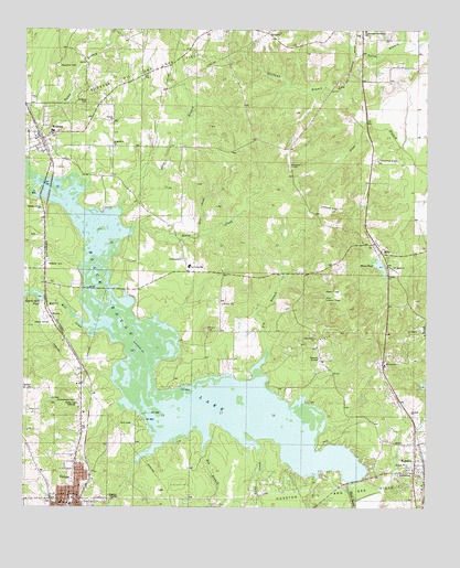
Vivian North, LA USGS Topographic Map
Click on map above to begin viewing in our Map Viewer.

This topographic map contains these locations and features:
Feature Name Type Latitude Longitude GNIS ID View Map
Antioch CemeteryCemeteryN32.9804°W93.9813°532180View Map
Antioch ChurchChurchN32.9774°W93.9730°532192View Map
Arkadelphia ChurchChurchN32.9407°W93.9507°532212View Map
Bee BranchStreamN32.8965°W93.9438°532876View Map
Big BranchStreamN32.9082°W93.9271°533047View Map
Black Bayou DamDamN32.8818°W93.8952°556695View Map
Black Bayou LakeReservoirN32.9007°W93.9430°553676View Map
Caddo Pine Island Oil FieldOilfieldN32.8979°W93.9641°552239View Map
Caddo Prairie ChurchChurchN32.9199°W93.9091°533608View Map
Chapelwood CemeteryCemeteryN32.9032°W93.9827°533876View Map
Colquitt ChurchChurchN32.9362°W93.8868°534054View Map
Frog Level (historical)Populated PlaceN32.9882°W93.9552°552286View Map
Gray BranchStreamN32.9515°W93.9718°535366View Map
Hartman BranchStreamN32.9765°W93.8938°535548View Map
Horse CreekStreamN32.9468°W93.9696°535803View Map
Hoss CreekStreamN32.9465°W93.9457°535825View Map
HosstonPopulated PlaceN32.8876°W93.8785°543315View Map
Hosston Oil and Gas FieldOilfieldN32.8799°W93.8888°535827View Map
Hosston Post OfficePost OfficeN32.8867°W93.8760°1631870View Map
KNCB-AM (Vivian)TowerN32.9021°W93.9830°1632572View Map
Lowe CreekStreamN32.8943°W93.9324°536762View Map
MiraPopulated PlaceN32.9421°W93.8891°543476View Map
Mira Lookout TowerTowerN32.9299°W93.9060°558805View Map
Mira Oil FieldOilfieldN32.9565°W93.9188°552357View Map
Mira PondReservoirN32.9382°W93.8895°555333View Map
Mira Pond DamDamN32.9385°W93.8885°557008View Map
Munnerlyn ChapelChurchN32.9649°W93.9168°537495View Map
MyrtisPopulated PlaceN32.9249°W93.9916°555453View Map
Myrtis Mill CreekStreamN32.9218°W93.9774°537511View Map
Myrtis Mill PondReservoirN32.9300°W93.9950°555454View Map
Myrtis Mill Pond DamDamN32.9301°W93.9935°557009View Map
Nazarene Christian Academy SchoolSchoolN32.8884°W93.9842°2462754View Map
North Caddo Community SchoolSchoolN32.9999°W93.8943°537718View Map
Old Bed Horseshoe LakeFlatN32.9543°W93.8788°540871View Map
Paradise ChurchChurchN32.9126°W93.8874°537964View Map
Pine Valley SchoolSchoolN32.9385°W93.9485°538197View Map
Pleasant Grove ChurchChurchN32.9535°W93.9949°538248View Map
RodessaPopulated PlaceN32.9712°W93.9949°538681View Map
Rodessa Oil and Gas FieldOilfieldN32.9887°W93.9643°538682View Map
Rodessa Post OfficePost OfficeN32.9715°W93.9955°1631896View Map
Saint Marks ChurchChurchN32.9379°W93.8852°538972View Map
Saint Matthew ChurchChurchN32.9701°W93.9718°538999View Map
Slaughter CemeteryCemeteryN32.9907°W93.9896°539414View Map
Stevens CemeteryCemeteryN32.9212°W93.9427°539664View Map
Thomas ChurchChurchN32.9001°W93.8793°539878View Map
VIivian Cemetery - Old SectionCemeteryN32.8776°W93.9907°2776792View Map
Village of HosstonCivilN32.8849°W93.8820°2407478View Map
Village of RodessaCivilN32.9735°W93.9968°2407538View Map
Vivian Cemetery New Section - Pine ParkCemeteryN32.8764°W93.9923°2781514View Map
Vivian Elementary and Middle SchoolSchoolN32.8759°W93.9859°552464View Map
Vivian Middle SchoolSchoolN32.8760°W93.9863°552465View Map
Ward NineCivilN32.9451°W93.9113°544948View Map

Note: Coordinates in the location and feature list above are referenced to NAD83 datum.


Copyright (C) 2008-2024 Ryan Niemi / Sunset Dynamics ... All Rights Reserved