TopoQuest Logo
Do you find TopoQuest useful?
Help keep TopoQuest running and adding new maps/features by donating!
Bitcoin:  19c7KJd3qBynnjoSw5npx9KScwjBe4ifkT
Litecoin:  LXs6TkuXGGXo1vDsWCkWVdjQX94eUKd6ui
Home View Maps Find Maps Find Places Resources & Links


Wagoner West, Oklahoma Topographic Map

USGS Map Title: Wagoner West, OK
USGS Map MRC: 35095H4
DRG (GeoTIFF) Download: o35095h4.tif


Neighboring USGS Topographic Map Quads:


  Catoosa SE, OK  
36095A5
 

  Neodesha, OK  
36095A4
 

  Rocky Point, OK  
36095A3
 

  Red Bird, OK  
35095H5
 

  Wagoner West, OK  
35095H4
 

  Wagoner East, OK  
35095H3
 

  Taft, OK  
35095G5
 

  Northwest Muskogee, OK  
35095G4
 

  Northeast Muskogee, OK  
35095G3


Map MRC Location:

N36°
W96°
N36°
W95°
H8 H7 H6 H5 H4 H3 H2 H1
G8 G7 G6 G5 G4 G3 G2 G1
F8 F7 F6 F5 F4 F3 F2 F1
E8 E7 E6 E5 E4 E3 E2 E1
D8 D7 D6 D5 D4 D3 D2 D1
C8 C7 C6 C5 C4 C3 C2 C1
B8 B7 B6 B5 B4 B3 B2 B1
A8 A7 A6 A5 A4 A3 A2 A1
N35°
W96°
N35°
W95°

Wagoner West, OK USGS 1:24K Topographic Map Preview:
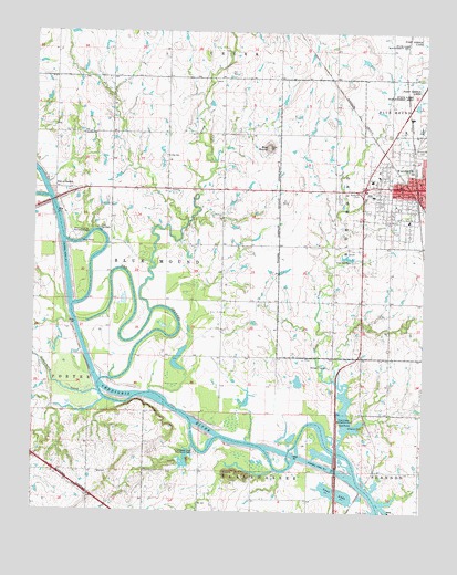
Wagoner West, OK USGS Topographic Map
Click on map above to begin viewing in our Map Viewer.

This topographic map contains these locations and features:
Feature Name Type Latitude Longitude GNIS ID View Map
Afton Landing Recreation AreaParkN35.9462°W95.4869°1089547View Map
Billy CreekStreamN35.9270°W95.4628°1090143View Map
Blue MoundSummitN35.9698°W95.4258°1090283View Map
City of WagonerCivilN35.9642°W95.3793°2412164View Map
Coal CreekStreamN35.8920°W95.4016°1091501View Map
Coal Creek Recreation AreaParkN35.8995°W95.3972°1091519View Map
Elmwood CemeteryCemeteryN35.9702°W95.3758°1092604View Map
First Presbyterian ChurchChurchN35.9620°W95.3775°1790072View Map
Grayson CemeteryCemeteryN35.8976°W95.3941°1093353View Map
KBIX-FM (Wagoner)TowerN35.9457°W95.4100°1102310View Map
KXTD-AM (Wagoner)TowerN35.9751°W95.4919°1102224View Map
Lincoln AcademySchoolN35.9510°W95.3807°2713030View Map
Oknoname 037018 DamDamN35.9468°W95.4519°1753219View Map
Oknoname 037018 ReservoirReservoirN35.9455°W95.4524°1753220View Map
Port of DunkinLocaleN35.9734°W95.4850°1096840View Map
Sandtown CemeteryCemeteryN35.9725°W95.4853°2724121View Map
Sandtown ChurchChurchN35.9590°W95.4936°1097792View Map
Star SchoolSchoolN35.9676°W95.4580°1098496View Map
Strawberry CreekStreamN35.9059°W95.4794°1098580View Map
Township of Blue MoundCivilN35.9584°W95.3780°1824582View Map
Tullahassee Loop Recreation AreaParkN35.8912°W95.4477°1099008View Map
Union Baptist ChurchChurchN35.9554°W95.3836°1790077View Map
Vans LakeLakeN35.8807°W95.4033°1099229View Map
Wagoner Community HospitalHospitalN35.9619°W95.3921°2695699View Map
Wagoner Emergency Medical ServicesBuildingN35.9565°W95.3754°2695935View Map
Wagoner Fire Department Station 1BuildingN35.9596°W95.3878°2656883View Map
Westwood Shopping CenterLocaleN35.9604°W95.3927°1778382View Map

Note: Coordinates in the location and feature list above are referenced to NAD83 datum.


Copyright (C) 2008-2025 Ryan Niemi / Sunset Dynamics ... All Rights Reserved