TopoQuest Logo
Do you find TopoQuest useful?
Help keep TopoQuest running and adding new maps/features by donating!
Bitcoin:  19c7KJd3qBynnjoSw5npx9KScwjBe4ifkT
Litecoin:  LXs6TkuXGGXo1vDsWCkWVdjQX94eUKd6ui
Home View Maps Find Maps Find Places Resources & Links


Wagram, North Carolina Topographic Map

USGS Map Title: Wagram, NC
USGS Map MRC: 34079H3
DRG (GeoTIFF) Download: o34079h3.tif


Neighboring USGS Topographic Map Quads:


  Pinebluff, NC  
35079A4
 

  McCain, NC  
35079A3
 

  Nicholson Creek, NC  
35079A2
 

  Silver Hill, NC  
34079H4
 

  Wagram, NC  
34079H3
 

  Raeford, NC  
34079H2
 

  Laurinburg, NC  
34079G4
 

  Wakulla, NC  
34079G3
 

  Red Springs, NC  
34079G2


Map MRC Location:

N35°
W80°
N35°
W79°
H8 H7 H6 H5 H4 H3 H2 H1
G8 G7 G6 G5 G4 G3 G2 G1
F8 F7 F6 F5 F4 F3 F2 F1
E8 E7 E6 E5 E4 E3 E2 E1
D8 D7 D6 D5 D4 D3 D2 D1
C8 C7 C6 C5 C4 C3 C2 C1
B8 B7 B6 B5 B4 B3 B2 B1
A8 A7 A6 A5 A4 A3 A2 A1
N34°
W80°
N34°
W79°

Wagram, NC USGS 1:24K Topographic Map Preview:
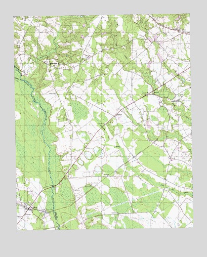
Wagram, NC USGS Topographic Map
Click on map above to begin viewing in our Map Viewer.

This topographic map contains these locations and features:
Feature Name Type Latitude Longitude GNIS ID View Map
Bethel ChurchChurchN34.9541°W79.2764°981115View Map
Bethel SchoolSchoolN34.9543°W79.2809°981182View Map
Blue CemeteryCemeteryN34.9852°W79.3725°981621View Map
BowmorePopulated PlaceN34.9421°W79.3031°981776View Map
Bowmore Census Designated PlaceCensusN34.9358°W79.3000°2402708View Map
Bowmore SchoolSchoolN34.9366°W79.3117°981777View Map
Brown CemeteryCemeteryN34.9996°W79.3611°981999View Map
Buffalo CreekStreamN34.9618°W79.3659°982172View Map
Buffalo Springs SchoolSchoolN34.9716°W79.3509°982185View Map
Crump TownPopulated PlaceN34.8868°W79.3564°1019872View Map
Drowning CreekStreamN34.9616°W79.3661°1010905View Map
Earl Hendrix DamDamN34.9318°W79.2781°998217View Map
Edenburg SchoolSchoolN34.9007°W79.3225°984628View Map
EdinburghPopulated PlaceN34.9057°W79.3100°1020105View Map
Freedom SchoolSchoolN34.9491°W79.2586°985386View Map
Gaineys PlacePopulated PlaceN34.9552°W79.3453°1020390View Map
Gilchrist CemeteryCemeteryN34.8974°W79.3550°985682View Map
Hendrix FarmsLocaleN34.9500°W79.2733°2647167View Map
Hickory GrovePopulated PlaceN34.9238°W79.3245°1020704View Map
Hoke Livestock FarmsLocaleN34.9114°W79.3042°2647160View Map
Love CemeteryCemeteryN34.9421°W79.3381°989046View Map
Macedonia SchoolSchoolN34.8838°W79.3028°989205View Map
McMillan CemeteryCemeteryN34.9507°W79.3384°989623View Map
McNeill CemeteryCemeteryN34.9315°W79.2681°989637View Map
Mountain Grove ChurchChurchN34.9746°W79.3248°990695View Map
New TownPopulated PlaceN34.8968°W79.3645°1021638View Map
North Scotland Volunteer Fire DepartmentBuildingN34.8873°W79.3645°2639527View Map
Purcell CemeteryCemeteryN34.8977°W79.3336°992916View Map
Raeford Livestock FarmsLocaleN34.8808°W79.3192°2647163View Map
Shady Grove ChurchChurchN34.9013°W79.3225°994540View Map
South Hoke Elementary SchoolSchoolN34.9149°W79.2642°1006659View Map
Town of WagramCivilN34.8891°W79.3652°2406815View Map
Township of Blue SpringsCivilN34.9413°W79.3024°1026802View Map
WagramPopulated PlaceN34.8879°W79.3662°1023093View Map
Wagram Police DepartmentBuildingN34.8857°W79.3657°2769692View Map
Wagram Post OfficePost OfficeN34.8854°W79.3688°2774375View Map
Wagram SchoolSchoolN34.8860°W79.3545°996671View Map
Watery BranchStreamN34.9627°W79.3692°996857View Map
West Hoke Elementary SchoolSchoolN34.9757°W79.3220°1006658View Map
West Hoke Fire DepartmentBuildingN34.9766°W79.3179°2639304View Map
Wrights PondReservoirN34.9747°W79.2712°998252View Map
Wrights Pond DamDamN34.9718°W79.2698°998253View Map

Note: Coordinates in the location and feature list above are referenced to NAD83 datum.


Copyright (C) 2008-2025 Ryan Niemi / Sunset Dynamics ... All Rights Reserved