TopoQuest Logo
Do you find TopoQuest useful?
Help keep TopoQuest running and adding new maps/features by donating!
Bitcoin:  19c7KJd3qBynnjoSw5npx9KScwjBe4ifkT
Litecoin:  LXs6TkuXGGXo1vDsWCkWVdjQX94eUKd6ui
Home View Maps Find Maps Find Places Resources & Links


Wakulla, North Carolina Topographic Map

USGS Map Title: Wakulla, NC
USGS Map MRC: 34079G3
DRG (GeoTIFF) Download: o34079g3.tif


Neighboring USGS Topographic Map Quads:


  Silver Hill, NC  
34079H4
 

  Wagram, NC  
34079H3
 

  Raeford, NC  
34079H2
 

  Laurinburg, NC  
34079G4
 

  Wakulla, NC  
34079G3
 

  Red Springs, NC  
34079G2
 

  Johns, NC  
34079F4
 

  Maxton, NC  
34079F3
 

  Pembroke, NC  
34079F2


Map MRC Location:

N35°
W80°
N35°
W79°
H8 H7 H6 H5 H4 H3 H2 H1
G8 G7 G6 G5 G4 G3 G2 G1
F8 F7 F6 F5 F4 F3 F2 F1
E8 E7 E6 E5 E4 E3 E2 E1
D8 D7 D6 D5 D4 D3 D2 D1
C8 C7 C6 C5 C4 C3 C2 C1
B8 B7 B6 B5 B4 B3 B2 B1
A8 A7 A6 A5 A4 A3 A2 A1
N34°
W80°
N34°
W79°

Wakulla, NC USGS 1:24K Topographic Map Preview:
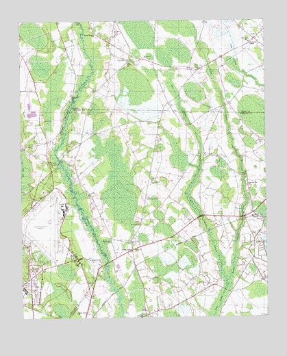
Wakulla, NC USGS Topographic Map
Click on map above to begin viewing in our Map Viewer.

This topographic map contains these locations and features:
Feature Name Type Latitude Longitude GNIS ID View Map
Burlington SchoolSchoolN34.8660°W79.2578°982280View Map
Centre ChurchChurchN34.7816°W79.3184°982974View Map
Cherokee Elementary SchoolSchoolN34.8060°W79.2589°1024815View Map
Conelly CemeteryCemeteryN34.8524°W79.3459°983448View Map
DuffiesPopulated PlaceN34.8671°W79.2548°984396View Map
Floral CollegePopulated PlaceN34.7785°W79.3184°1020292View Map
Island Grove ChurchChurchN34.8077°W79.3081°987431View Map
Island Grove SchoolSchoolN34.8004°W79.3109°987432View Map
Jordan SwampStreamN34.7652°W79.2700°987781View Map
Laurinburg-Maxton Air Force Base (historical)MilitaryN34.7878°W79.3636°2091949View Map
Laurinburg-Maxton AirportAirportN34.7953°W79.3694°997862View Map
Laurinburg-Maxton Army Air Base (historical)MilitaryN34.7878°W79.3636°2091950View Map
Lees Mill Pond DamDamN34.8185°W79.3748°998139View Map
Lillys Chapel CemeteryCemeteryN34.8582°W79.3195°988486View Map
Lillys Chapel SchoolSchoolN34.8579°W79.3189°988487View Map
Little ChurchChurchN34.7529°W79.3109°988571View Map
McBryde CemeteryCemeteryN34.8246°W79.2520°989527View Map
McCormack ChapelChurchN34.8652°W79.2573°989544View Map
McLaughlin CemeteryCemeteryN34.7665°W79.3098°989605View Map
McLean CemeteryCemeteryN34.8593°W79.3117°989608View Map
McPhatter CemeteryCemeteryN34.8704°W79.3267°989645View Map
Mount Zion SchoolSchoolN34.8285°W79.2581°990682View Map
Saint Peters ChurchChurchN34.7891°W79.3142°994109View Map
Sandy Grove ChurchChurchN34.7524°W79.3470°994275View Map
Scotland Correctional InstitutionBuildingN34.8117°W79.3649°2769873View Map
Smith CemeteryCemeteryN34.7913°W79.2512°994942View Map
Smiths Volunteer Fire DepartmentBuildingN34.8103°W79.2910°2639021View Map
Spring Branch ChurchChurchN34.8691°W79.3370°995328View Map
Sycamore Hill ChurchChurchN34.7732°W79.3342°995795View Map
Thunder ParkParkN34.7543°W79.3184°2612160View Map
Township of AllendaleCivilN34.8679°W79.2938°1026800View Map
Township of SmithsCivilN34.7796°W79.2720°1027123View Map
WakullaPopulated PlaceN34.7927°W79.2550°996685View Map
Wakulla Census Designated PlaceCensusN34.7970°W79.2560°2584334View Map
Wilkinson CemeteryCemeteryN34.7646°W79.2801°997340View Map
Wilson SchoolSchoolN34.7821°W79.3292°997459View Map

Note: Coordinates in the location and feature list above are referenced to NAD83 datum.


Copyright (C) 2008-2024 Ryan Niemi / Sunset Dynamics ... All Rights Reserved