TopoQuest Logo
Do you find TopoQuest useful?
Help keep TopoQuest running and adding new maps/features by donating!
Bitcoin:  19c7KJd3qBynnjoSw5npx9KScwjBe4ifkT
Litecoin:  LXs6TkuXGGXo1vDsWCkWVdjQX94eUKd6ui
Home View Maps Find Maps Find Places Resources & Links


Walker Point, Utah Topographic Map

USGS Map Title: Walker Point, UT
USGS Map MRC: 39109C7
DRG (GeoTIFF) Download: o39109c7.tif


Neighboring USGS Topographic Map Quads:


  Moonwater Point, UT  
39109D8
 

  Chicken Fork, UT  
39109D7
 

  Black Knolls, UT  
39109D6
 

  Lion Canyon, UT  
39109C8
 

  Walker Point, UT  
39109C7
 

  Supply Canyon, UT  
39109C6
 

  Bobby Canyon North, UT  
39109B8
 

  Floy Canyon North, UT  
39109B7
 

  Bogart Canyon, UT  
39109B6


Map MRC Location:

N40°
W110°
N40°
W109°
H8 H7 H6 H5 H4 H3 H2 H1
G8 G7 G6 G5 G4 G3 G2 G1
F8 F7 F6 F5 F4 F3 F2 F1
E8 E7 E6 E5 E4 E3 E2 E1
D8 D7 D6 D5 D4 D3 D2 D1
C8 C7 C6 C5 C4 C3 C2 C1
B8 B7 B6 B5 B4 B3 B2 B1
A8 A7 A6 A5 A4 A3 A2 A1
N39°
W110°
N39°
W109°

Walker Point, UT USGS 1:24K Topographic Map Preview:
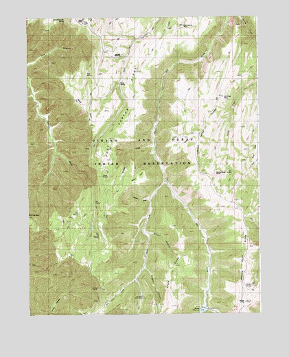
Walker Point, UT USGS Topographic Map
Click on map above to begin viewing in our Map Viewer.

This topographic map contains these locations and features:
Feature Name Type Latitude Longitude GNIS ID View Map
Bear Trap KnollSummitN39.2919°W109.8749°1425360View Map
Beaver CanyonValleyN39.2839°W109.8107°1425376View Map
Big SpringSpringN39.2973°W109.8390°1425553View Map
Bolon SpringSpringN39.3470°W109.8250°1425864View Map
Crib SpringSpringN39.2925°W109.8486°1427100View Map
Dry ForkStreamN39.2644°W109.8179°1427536View Map
Florence SpringSpringN39.2828°W109.8372°1428020View Map
Hill Creek PointSummitN39.3414°W109.7693°1428717View Map
Hill Creek Ranger StationLocaleN39.3583°W109.8243°1428718View Map
Hill Creek Youth CampLocaleN39.2572°W109.8135°1428719View Map
Jack SpringSpringN39.3095°W109.7650°1429080View Map
Jennie CanyonValleyN39.2694°W109.8121°1429140View Map
Little Mountain SpringSpringN39.3739°W109.8546°1429772View Map
Marble SpringSpringN39.2617°W109.7554°1430098View Map
Nelson DrawValleyN39.2983°W109.8101°1430681View Map
Post Canyon PointSummitN39.3708°W109.7901°1431429View Map
Post Canyon RidgeRidgeN39.3436°W109.8140°1431430View Map
Seeley SpringSpringN39.3084°W109.8321°1432312View Map
Spring Creek PointCliffN39.3083°W109.7743°1432845View Map
Spring Creek RidgeRidgeN39.3264°W109.7815°1432846View Map
Steer RidgeRidgeN39.2569°W109.7993°1432956View Map
Sunrise DugwayTrailN39.2605°W109.8387°1433071View Map
Toad PointCliffN39.3727°W109.8446°1433557View Map
Uintah and Ouray DivisionCivilN39.3518°W109.8289°1939426View Map
Wagon Road RidgeRidgeN39.2777°W109.7560°1433916View Map
Walker DrawValleyN39.3208°W109.8074°1433927View Map
Walker PointCapeN39.3066°W109.8137°1433931View Map
Weaver ReservoirReservoirN39.2502°W109.7822°1434021View Map
West Fork Hill CreekStreamN39.3055°W109.8001°1434075View Map
West PointCapeN39.3291°W109.8385°1434107View Map
West SpringSpringN39.3512°W109.8428°1434117View Map
Wilcox PointSummitN39.2547°W109.7590°1434246View Map

Note: Coordinates in the location and feature list above are referenced to NAD83 datum.


Copyright (C) 2008-2025 Ryan Niemi / Sunset Dynamics ... All Rights Reserved