TopoQuest Logo
Do you find TopoQuest useful?
Help keep TopoQuest running and adding new maps/features by donating!
Bitcoin:  19c7KJd3qBynnjoSw5npx9KScwjBe4ifkT
Litecoin:  LXs6TkuXGGXo1vDsWCkWVdjQX94eUKd6ui
Home View Maps Find Maps Find Places Resources & Links


Wall Creek, Wyoming Topographic Map

USGS Map Title: Wall Creek, WY
USGS Map MRC: 43106E5
DRG (GeoTIFF) Download: o43106e5.tif


Neighboring USGS Topographic Map Quads:


  Kaycee, WY  
43106F6
 

  Kaycee NE, WY  
43106F5
 

  Figure 8 Reservoir, WY  
43106F4
 

  TTT Ranch, WY  
43106E6
 

  Wall Creek, WY  
43106E5
 

  Dugout Ranch, WY  
43106E4
 

  Broken Horn Creek, WY  
43106D6
 

  Salt Canyon, WY  
43106D5
 

  Government Creek, WY  
43106D4


Map MRC Location:

N44°
W107°
N44°
W106°
H8 H7 H6 H5 H4 H3 H2 H1
G8 G7 G6 G5 G4 G3 G2 G1
F8 F7 F6 F5 F4 F3 F2 F1
E8 E7 E6 E5 E4 E3 E2 E1
D8 D7 D6 D5 D4 D3 D2 D1
C8 C7 C6 C5 C4 C3 C2 C1
B8 B7 B6 B5 B4 B3 B2 B1
A8 A7 A6 A5 A4 A3 A2 A1
N43°
W107°
N43°
W106°

Wall Creek, WY USGS 1:24K Topographic Map Preview:
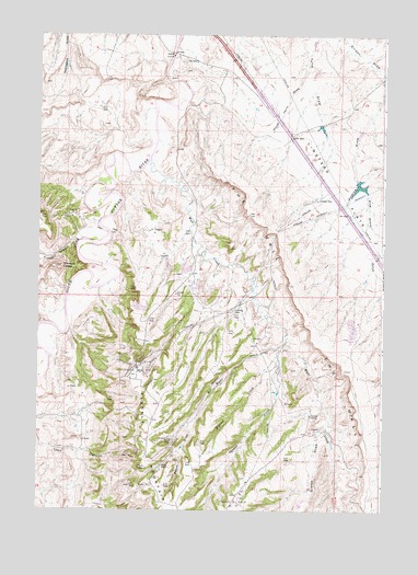
Wall Creek, WY USGS Topographic Map
Click on map above to begin viewing in our Map Viewer.

This topographic map contains these locations and features:
Feature Name Type Latitude Longitude GNIS ID View Map
Andrus DamDamN43.6016°W106.5073°1608464View Map
Andrus ReservoirReservoirN43.6016°W106.5073°1608465View Map
Beach DrawValleyN43.5216°W106.5700°1585229View Map
Butts RanchLocaleN43.5119°W106.5798°1586221View Map
East Tisdale Oil FieldOilfieldN43.5036°W106.5531°1588147View Map
Frewens CastleSummitN43.5639°W106.6167°1588756View Map
Frewens DrawValleyN43.5711°W106.6114°1588757View Map
Gierse DrawValleyN43.5214°W106.5217°1588900View Map
Hot Water CreekStreamN43.5452°W106.5353°1589757View Map
Kaycee Bentonite Corporation Number Eighteen MineMineN43.5525°W106.5914°1746215View Map
Kaycee Bentonite Corporation Number Eleven MineMineN43.5322°W106.5459°1746208View Map
Kaycee Bentonite Corporation Number Fifteen MineMineN43.5480°W106.5614°1746212View Map
Kaycee Bentonite Corporation Number Fourteen MineMineN43.5439°W106.5731°1746211View Map
Kaycee Bentonite Corporation Number Seventeen MineMineN43.5527°W106.5884°1746214View Map
Kaycee Bentonite Corporation Number Sixteen MineMineN43.5008°W106.5834°1746213View Map
Kaycee Bentonite Corporation Number Ten MineMineN43.5322°W106.5462°1746207View Map
Kaycee Bentonite Corporation Number Three MineMineN43.5439°W106.5695°1746210View Map
Kaycee Bentonite Corporation Number Twelve MineMineN43.5400°W106.5750°1746209View Map
Kaycee Bentonite Corporation Number Twenty-five MineMineN43.5600°W106.5845°1746220View Map
Kaycee Bentonite Corporation Number Twenty-four MineMineN43.5580°W106.5823°1746219View Map
Kaycee Bentonite Corporation Number Twenty-one MineMineN43.5541°W106.5787°1746216View Map
Kaycee Bentonite Corporation Number Twenty-six MineMineN43.5652°W106.5831°1746221View Map
Kaycee Bentonite Corporation Number Twenty-three MineMineN43.5580°W106.5867°1746218View Map
Kaycee Bentonite Corporation Number Twenty-two MineMineN43.5544°W106.5825°1746217View Map
Linstead FlatsFlatN43.5864°W106.5175°1590719View Map
Linstead PlacePopulated PlaceN43.5825°W106.5228°1597384View Map
Million CreekStreamN43.5411°W106.5378°1591625View Map
North DamDamN43.5166°W106.5239°1606592View Map
North ReservoirReservoirN43.5166°W106.5239°1606593View Map
North Terry DrawValleyN43.6161°W106.5278°1592290View Map
North Tisdale Oil FieldOilfieldN43.5383°W106.5873°1592293View Map
Pine Grove GulchValleyN43.5844°W106.5070°1592781View Map
Robertson DamDamN43.6200°W106.5239°1606492View Map
Robertson ReservoirReservoirN43.6200°W106.5239°1606493View Map
Shiloh WellWellN43.5189°W106.5784°1594263View Map
Snyder RanchLocaleN43.5250°W106.5259°1594528View Map
South Fork Powder River MineMineN43.6066°W106.5806°1746222View Map
The WallCliffN43.5541°W106.5314°1595481View Map
Thomas CreekStreamN43.5427°W106.5375°1595501View Map
Tisdale MountainSummitN43.5114°W106.5881°1595602View Map
Tisdale Number Four MineMineN43.5402°W106.5734°1746226View Map
Tisdale Number Nine MineMineN43.5094°W106.5314°1746229View Map
Tisdale Number One MineMineN43.5486°W106.5662°1746223View Map
Tisdale Number Seven MineMineN43.5205°W106.5462°1746228View Map
Tisdale Number Six MineMineN43.5133°W106.5314°1746227View Map
Tisdale Number Ten MineMineN43.5633°W106.5856°1746230View Map
Tisdale Number Three MineMineN43.5350°W106.5850°1746225View Map
Tisdale Number Two MineMineN43.5486°W106.5845°1746224View Map
Wall CreekStreamN43.5886°W106.5909°1596005View Map

Note: Coordinates in the location and feature list above are referenced to NAD83 datum.


Copyright (C) 2008-2025 Ryan Niemi / Sunset Dynamics ... All Rights Reserved