TopoQuest Logo
Do you find TopoQuest useful?
Help keep TopoQuest running and adding new maps/features by donating!
Bitcoin:  19c7KJd3qBynnjoSw5npx9KScwjBe4ifkT
Litecoin:  LXs6TkuXGGXo1vDsWCkWVdjQX94eUKd6ui
Home View Maps Find Maps Find Places Resources & Links


Wallace, Virginia Topographic Map

USGS Map Title: Wallace, VA
USGS Map MRC: 36082F2
DRG (GeoTIFF) Download: o36082f2.tif


Neighboring USGS Topographic Map Quads:


  Moll Creek, VA  
36082G3
 

  Hansonville, VA  
36082G2
 

  Brumley, VA  
36082G1
 

  Mendota, VA  
36082F3
 

  Wallace, VA  
36082F2
 

  Wyndale, VA  
36082F1
 

  Blountville, TN  
36082E3
 

  Bristol, TN  
36082E2
 

  Holston Valley, TN  
36082E1


Map MRC Location:

N37°
W83°
N37°
W82°
H8 H7 H6 H5 H4 H3 H2 H1
G8 G7 G6 G5 G4 G3 G2 G1
F8 F7 F6 F5 F4 F3 F2 F1
E8 E7 E6 E5 E4 E3 E2 E1
D8 D7 D6 D5 D4 D3 D2 D1
C8 C7 C6 C5 C4 C3 C2 C1
B8 B7 B6 B5 B4 B3 B2 B1
A8 A7 A6 A5 A4 A3 A2 A1
N36°
W83°
N36°
W82°

Wallace, VA USGS 1:24K Topographic Map Preview:
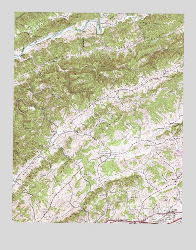
Wallace, VA USGS Topographic Map
Click on map above to begin viewing in our Map Viewer.

This topographic map contains these locations and features:
Feature Name Type Latitude Longitude GNIS ID View Map
Baltzell CemeteryCemeteryN36.6762°W82.1571°1462756View Map
Bellamy HollowValleyN36.7455°W82.1600°1463036View Map
BenhamsPopulated PlaceN36.6787°W82.2182°1499118View Map
Bethany Church (historical)ChurchN36.6509°W82.2493°1498227View Map
Big Jack RidgeRidgeN36.6576°W82.2112°1463367View Map
Big RidgeRidgeN36.6301°W82.2040°1487031View Map
Big SpringSpringN36.6428°W82.2391°1463410View Map
Booner CemeteryCemeteryN36.6404°W82.1626°1463665View Map
Bristol ReservoirReservoirN36.6462°W82.1821°1498230View Map
Bufallo Pond SchoolSchoolN36.6746°W82.1565°1498231View Map
Buffalo FordCrossingN36.7476°W82.1860°1499181View Map
Buffalo School (historical)SchoolN36.6676°W82.1785°1498232View Map
Burson CemeteryCemeteryN36.6645°W82.1749°1464146View Map
Burson PlacePopulated PlaceN36.6659°W82.1776°1499197View Map
Calvary Bible ChurchChurchN36.6640°W82.1801°1464267View Map
Campground ChurchChurchN36.6632°W82.2268°1464381View Map
Caney ValleyBasinN36.7284°W82.1876°1464413View Map
Cedar Grove ChurchChurchN36.7001°W82.1799°1464614View Map
Centenary ChurchChurchN36.7484°W82.1599°1464665View Map
Chinquapin School (historical)SchoolN36.6551°W82.2201°1498240View Map
Clear Branch ChurchChurchN36.6776°W82.1318°1464966View Map
Clear Branch Church CemeteryCemeteryN36.6780°W82.1317°2774736View Map
Crabtree CemeteryCemeteryN36.7482°W82.1604°1465377View Map
Craigs MillPopulated PlaceN36.7484°W82.1618°1499301View Map
Craigs Mill School (historical)SchoolN36.7490°W82.1637°1498244View Map
Crawford HollowValleyN36.7036°W82.1742°1482817View Map
Crystal PoolReservoirN36.6343°W82.1532°1498246View Map
Cunningham CemeteryCemeteryN36.7445°W82.1740°1465528View Map
Dinsmore CemeteryCemeteryN36.7457°W82.1840°1465813View Map
Dominion Post OfficePost OfficeN36.6253°W82.1631°2780823View Map
Fleenor CemeteryCemeteryN36.6493°W82.2215°1466678View Map
Fleenor CemeteryCemeteryN36.6818°W82.2132°1466679View Map
Fleenor CemeteryCemeteryN36.6848°W82.1365°1466680View Map
Fleenor SpringPopulated PlaceN36.6821°W82.1379°1499424View Map
FleenorsPopulated PlaceN36.7043°W82.1629°1498258View Map
Fleenors CemeteryCemeteryN36.7062°W82.1549°1498259View Map
Free Hill CemeteryCemeteryN36.7317°W82.1630°1466865View Map
Free Hill ChurchChurchN36.7287°W82.1676°1466866View Map
Garrett CemeteryCemeteryN36.7237°W82.2121°1467005View Map
Gaspard CreekStreamN36.7471°W82.1596°1467017View Map
Gobble CemeteryCemeteryN36.7432°W82.1260°1467176View Map
Goodson - Kinderhook Fire and Rescue Station 1BuildingN36.6643°W82.1802°2721075View Map
Goodson CemeteryCemeteryN36.6868°W82.1382°1467229View Map
Goose CreekStreamN36.6321°W82.1329°1467246View Map
Gum Hill ChurchChurchN36.6809°W82.2407°1467600View Map
Gum Hill School (historical)SchoolN36.6818°W82.2387°1498268View Map
Gunpowder Siding (historical)LocaleN36.6429°W82.1943°1498269View Map
Hall CemeteryCemeteryN36.7304°W82.2329°1467665View Map
Hanner CemeteryCemeteryN36.6745°W82.1346°1467714View Map
Harley SpringSpringN36.6852°W82.1344°1467751View Map
Hartsock CemeteryCemeteryN36.6382°W82.1690°1467801View Map
HaskellPopulated PlaceN36.6479°W82.1924°1499534View Map
Haskell BranchStreamN36.6723°W82.2204°1467813View Map
Hendricks CemeteryCemeteryN36.7266°W82.2448°2774740View Map
Horn CemeteryCemeteryN36.7384°W82.2079°1468238View Map
Interchange 3CrossingN36.6257°W82.1793°1673818View Map
Interchange 5CrossingN36.6262°W82.1551°1673819View Map
Jackson CemeteryCemeteryN36.6687°W82.1426°1468594View Map
Johnson CemeteryCemeteryN36.7340°W82.1440°1468778View Map
Krimmel CreekStreamN36.7304°W82.1424°1469080View Map
Large CemeteryCemeteryN36.7373°W82.1565°1469134View Map
LeonardPopulated PlaceN36.6982°W82.2451°1499657View Map
Leonard HollowValleyN36.6968°W82.2475°1469309View Map
Lime HillPopulated PlaceN36.6490°W82.2474°1477491View Map
Lime Hill ChurchChurchN36.6493°W82.2471°1498298View Map
Linder CemeteryCemeteryN36.7434°W82.1787°1469441View Map
Lippincott ChurchChurchN36.6537°W82.1985°1469452View Map
Lone StarPopulated PlaceN36.6907°W82.2274°1498300View Map
Malone CemeteryCemeteryN36.6326°W82.2240°1470033View Map
McCroskey CemeteryCemeteryN36.7209°W82.1268°1470247View Map
McGuire HollowValleyN36.7299°W82.1422°1470262View Map
Memorial ChurchChurchN36.7068°W82.1543°1470355View Map
Moore CemeteryCemeteryN36.6515°W82.1904°1470705View Map
Morrison SchoolSchoolN36.6349°W82.1410°2498415View Map
Mount Lebanon ChurchChurchN36.6537°W82.1282°1470920View Map
Muddy HollowValleyN36.7361°W82.1998°1471232View Map
NordykeLocaleN36.7209°W82.2110°1848399View Map
Nordyke CreekStreamN36.7232°W82.2471°1471563View Map
Nordyke School (historical)SchoolN36.7187°W82.2176°1498316View Map
Oak GrovePopulated PlaceN36.6446°W82.1801°1499811View Map
Ornduff CemeteryCemeteryN36.6570°W82.1529°1471953View Map
Phillips SpringSpringN36.6714°W82.1456°1472260View Map
Pine Hill ChurchChurchN36.7040°W82.1315°1472356View Map
Pine Hill Church CemeteryCemeteryN36.7040°W82.1313°2774744View Map
Pine Hill School (historical)SchoolN36.7043°W82.1310°1498322View Map
Pleasant Dale School (historical)SchoolN36.7048°W82.1679°1499034View Map
Possum HollowValleyN36.6484°W82.1350°1472690View Map
Rattle CreekStreamN36.7157°W82.2124°1473011View Map
Ravens NestPopulated PlaceN36.7245°W82.2490°2027184View Map
Revival Center ChurchChurchN36.6671°W82.1782°1473163View Map
Riverview CemeteryCemeteryN36.7423°W82.1926°1473272View Map
Riverview ChurchChurchN36.7390°W82.2010°1473273View Map
Riverview School (historical)SchoolN36.7387°W82.2010°1498329View Map
Robinette GapGapN36.7357°W82.2362°1473334View Map
Rock CemeteryCemeteryN36.7112°W82.1421°1473358View Map
RocktownPopulated PlaceN36.7123°W82.1401°1499982View Map
Rush CornerPopulated PlaceN36.6959°W82.1915°1500004View Map
Rust CemeteryCemeteryN36.6376°W82.2018°1473658View Map
Shankel CemeteryCemeteryN36.6259°W82.2493°1474216View Map
Shiloh ChurchChurchN36.6340°W82.1807°1474498View Map
Smiley HollowValleyN36.7153°W82.2339°1474714View Map
Smith CreekStreamN36.7384°W82.1854°1487340View Map
Sugar Grove ChurchChurchN36.6793°W82.2079°1475280View Map
Sugar Grove School (historical)SchoolN36.6795°W82.2085°1498340View Map
Sullins AcademySchoolN36.6344°W82.1522°2498480View Map
Sweetie HollowValleyN36.6769°W82.1318°1475385View Map
Tyler DistrictCivilN36.6914°W82.2112°1927543View Map
Vickers HollowValleyN36.7160°W82.1896°1476180View Map
WallacePopulated PlaceN36.6529°W82.1279°1500271View Map
Wallace Middle SchoolSchoolN36.6502°W82.1307°1498356View Map
Walnut GrovePopulated PlaceN36.6321°W82.1310°1673849View Map
Walnut Grove ChurchChurchN36.6329°W82.1296°1476276View Map
Walnut Grove School (historical)SchoolN36.7087°W82.2493°1498357View Map
Williams CemeteryCemeteryN36.7379°W82.1368°1476752View Map
Wolfrun (historical)Populated PlaceN36.6968°W82.2482°1498374View Map
Wood CemeteryCemeteryN36.7151°W82.2149°1476924View Map
WoodsdalePopulated PlaceN36.6284°W82.2293°1498373View Map
Wooten GapGapN36.7432°W82.2107°1476988View Map
Worsham CemeteryCemeteryN36.6662°W82.1824°1476995View Map
WZAP-AM (Bristol)TowerN36.6309°W82.1646°1498922View Map

Note: Coordinates in the location and feature list above are referenced to NAD83 datum.


Copyright (C) 2008-2025 Ryan Niemi / Sunset Dynamics ... All Rights Reserved