TopoQuest Logo
Do you find TopoQuest useful?
Help keep TopoQuest running and adding new maps/features by donating!
Bitcoin:  19c7KJd3qBynnjoSw5npx9KScwjBe4ifkT
Litecoin:  LXs6TkuXGGXo1vDsWCkWVdjQX94eUKd6ui
Home View Maps Find Maps Find Places Resources & Links


Walnut Ridge SE, Arkansas Topographic Map

USGS Map Title: Walnut Ridge SE, AR
USGS Map MRC: 36090A7
DRG (GeoTIFF) Download: o36090a7.tif


Neighboring USGS Topographic Map Quads:


  Manson, AR  
36090B8
 

  O'Kean, AR  
36090B7
 

  Delaplaine, AR  
36090B6
 

  Walnut Ridge, AR  
36090A8
 

  Walnut Ridge SE, AR  
36090A7
 

  Walcott, AR  
36090A6
 

  Podo Creek, AR  
35090H8
 

  Bono, AR  
35090H7
 

  Lorado, AR  
35090H6


Map MRC Location:

N37°
W91°
N37°
W90°
H8 H7 H6 H5 H4 H3 H2 H1
G8 G7 G6 G5 G4 G3 G2 G1
F8 F7 F6 F5 F4 F3 F2 F1
E8 E7 E6 E5 E4 E3 E2 E1
D8 D7 D6 D5 D4 D3 D2 D1
C8 C7 C6 C5 C4 C3 C2 C1
B8 B7 B6 B5 B4 B3 B2 B1
A8 A7 A6 A5 A4 A3 A2 A1
N36°
W91°
N36°
W90°

Walnut Ridge SE, AR USGS 1:24K Topographic Map Preview:
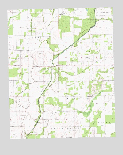
Walnut Ridge SE, AR USGS Topographic Map
Click on map above to begin viewing in our Map Viewer.

This topographic map contains these locations and features:
Feature Name Type Latitude Longitude GNIS ID View Map
Buffalo Head SloughStreamN36.0067°W90.8504°47157View Map
Byral School (historical)SchoolN36.1201°W90.7968°64020View Map
Duck Branch DitchCanalN36.1109°W90.8462°48675View Map
Fender CemeteryCemeteryN36.1242°W90.8229°49025View Map
Fender School (historical)SchoolN36.1023°W90.8512°64023View Map
Float Road DitchCanalN36.0467°W90.8565°76942View Map
FontainePopulated PlaceN36.0006°W90.8134°76944View Map
Fontaine Baptist ChurchChurchN36.0003°W90.8082°64804View Map
Jenkins CemeteryCemeteryN36.0623°W90.8487°50617View Map
Lateral Number 3CanalN36.0742°W90.7679°82487View Map
Light Baptist ChurchChurchN36.0701°W90.7521°64825View Map
Light School (historical)SchoolN36.0703°W90.7529°64826View Map
Negro Head SloughStreamN36.0609°W90.7926°52598View Map
New Covenant ChurchChurchN36.0851°W90.8507°52636View Map
Number 26 DitchCanalN36.0173°W90.7712°82526View Map
Oak Grove ChurchChurchN36.0165°W90.8704°52917View Map
Oak Grove School (historical)SchoolN36.0162°W90.8707°64032View Map
Poplar CreekStreamN36.0101°W90.7790°53692View Map
Ray CemeteryCemeteryN36.0820°W90.8368°53920View Map
Shady Grove CemeteryCemeteryN36.0006°W90.8073°54696View Map
Township of BryanCivilN36.0803°W90.7607°66617View Map
Township of CacheCivilN36.1086°W90.8333°66787View Map
Township of Walnut CornerCivilN36.0398°W90.7901°66638View Map
Tupelo SloughStreamN36.1162°W90.8198°55708View Map
Walnut CornerPopulated PlaceN36.0403°W90.7757°57228View Map
Walnut Corner School (historical)SchoolN36.0415°W90.7743°64892View Map
WhiskervillePopulated PlaceN36.1198°W90.8132°58864View Map
Woodland School (historical)SchoolN36.0703°W90.8034°64898View Map

Note: Coordinates in the location and feature list above are referenced to NAD83 datum.


Copyright (C) 2008-2024 Ryan Niemi / Sunset Dynamics ... All Rights Reserved