TopoQuest Logo
Do you find TopoQuest useful?
Help keep TopoQuest running and adding new maps/features by donating!
Bitcoin:  19c7KJd3qBynnjoSw5npx9KScwjBe4ifkT
Litecoin:  LXs6TkuXGGXo1vDsWCkWVdjQX94eUKd6ui
Home View Maps Find Maps Find Places Resources & Links


Warsaw South, North Carolina Topographic Map

USGS Map Title: Warsaw South, NC
USGS Map MRC: 34078H1
DRG (GeoTIFF) Download: o34078h1.tif


Neighboring USGS Topographic Map Quads:


  Faison, NC  
35078A2
 

  Warsaw North, NC  
35078A1
 

  Summerlins Crossroads, NC  
35077A8
 

  Turkey, NC  
34078H2
 

  Warsaw South, NC  
34078H1
 

  Kenansville, NC  
34077H8
 

  Delway, NC  
34078G2
 

  Rose Hill, NC  
34078G1
 

  Charity, NC  
34077G8


Map MRC Location:

N35°
W79°
N35°
W78°
H8 H7 H6 H5 H4 H3 H2 H1
G8 G7 G6 G5 G4 G3 G2 G1
F8 F7 F6 F5 F4 F3 F2 F1
E8 E7 E6 E5 E4 E3 E2 E1
D8 D7 D6 D5 D4 D3 D2 D1
C8 C7 C6 C5 C4 C3 C2 C1
B8 B7 B6 B5 B4 B3 B2 B1
A8 A7 A6 A5 A4 A3 A2 A1
N34°
W79°
N34°
W78°

Warsaw South, NC USGS 1:24K Topographic Map Preview:
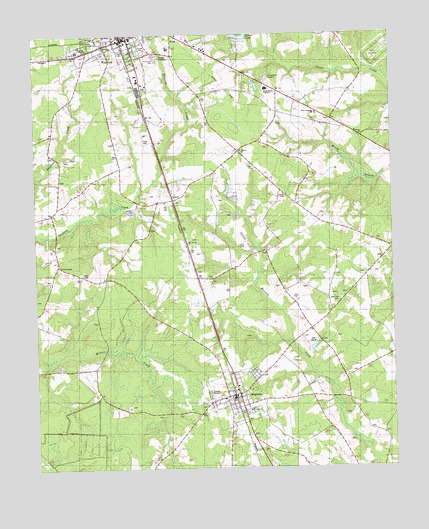
Warsaw South, NC USGS Topographic Map
Click on map above to begin viewing in our Map Viewer.

This topographic map contains these locations and features:
Feature Name Type Latitude Longitude GNIS ID View Map
Beasleys MillpondLakeN34.9088°W78.0964°1008042View Map
Carlton Methodist ChapelChurchN34.9338°W78.1161°1008239View Map
CarrollPopulated PlaceN34.9521°W78.0761°982682View Map
Carroll Street Pentecostal Free Will Baptist ChurchChurchN34.8953°W78.0556°2647871View Map
Devotional Gardens CemeteryCemeteryN34.9872°W78.0433°1025284View Map
Douglass Junior High SchoolSchoolN34.9957°W78.1094°1001131View Map
Duplin County Emergency Medical Services Medic 1BuildingN34.9979°W78.0928°2720374View Map
Hines ChapelChurchN34.9982°W78.1036°1003670View Map
James Kenan High SchoolSchoolN34.9843°W78.0391°987912View Map
Johnson ChurchChurchN34.9668°W78.0525°1008240View Map
MagnoliaPopulated PlaceN34.8966°W78.0542°989232View Map
Magnolia Police DepartmentBuildingN34.8957°W78.0557°2130876View Map
Magnolia Post OfficePost OfficeN34.8972°W78.0533°2505382View Map
Magnolia Volunteer Fire DepartmentBuildingN34.8960°W78.0551°2638454View Map
Magnolia Wastewater Treatment PlantLocaleN34.8983°W78.0667°2506010View Map
Mount Calvary ChurchChurchN34.9402°W78.0711°990327View Map
Pine Crest CemeteryCemeteryN34.9938°W78.0814°992234View Map
Rainbow ChapelChurchN34.9538°W78.0375°992993View Map
Rose Hill CemeteryCemeteryN34.9238°W78.0183°1003673View Map
Saint Peter ChurchChurchN34.8918°W78.0503°1003674View Map
Saint Stephens ChurchChurchN34.9966°W78.1003°1003671View Map
Silver LakeReservoirN34.9992°W78.0519°1025700View Map
Taylor FieldParkN34.9960°W78.0942°1001099View Map
Town of MagnoliaCivilN34.8964°W78.0536°2406079View Map
Town of WarsawCivilN34.9987°W78.0925°2406833View Map
Township of MagnoliaCivilN34.8798°W78.0956°1026646View Map
Township of WarsawCivilN34.9952°W78.0904°1026650View Map
WarsawPopulated PlaceN34.9993°W78.0911°996815View Map
Warsaw Elementary SchoolSchoolN34.9965°W78.0767°1001132View Map
Warsaw Fire DepartmentBuildingN34.9981°W78.0922°2638569View Map
Warsaw Police DepartmentBuildingN34.9979°W78.0928°2130875View Map
Warsaw Wastewater Treatment PlantLocaleN34.9930°W78.0803°2506335View Map
West Duplin ChurchChurchN34.9774°W78.0269°1003672View Map
Williams SchoolSchoolN34.8866°W78.0578°997389View Map

Note: Coordinates in the location and feature list above are referenced to NAD83 datum.


Copyright (C) 2008-2024 Ryan Niemi / Sunset Dynamics ... All Rights Reserved