TopoQuest Logo
Do you find TopoQuest useful?
Help keep TopoQuest running and adding new maps/features by donating!
Bitcoin:  19c7KJd3qBynnjoSw5npx9KScwjBe4ifkT
Litecoin:  LXs6TkuXGGXo1vDsWCkWVdjQX94eUKd6ui
Home View Maps Find Maps Find Places Resources & Links


Bonaparte, Iowa Topographic Map

USGS Map Title: Bonaparte, IA
USGS Map MRC: 40091F7
DRG (GeoTIFF) Download: o40091f7.tif


Neighboring USGS Topographic Map Quads:


  Mount Zion, IA  
40091G8
 

  Stockport, IA  
40091G7
 

  Hillsboro, IA  
40091G6
 

  Keosauqua, IA  
40091F8
 

  Bonaparte, IA  
40091F7
 

  Farmington, IA  
40091F6
 

  Mount Sterling, IA  
40091E8
 

  Anson, MO  
40091E7
 

  Croton, IA  
40091E6


Map MRC Location:

N41°
W92°
N41°
W91°
H8 H7 H6 H5 H4 H3 H2 H1
G8 G7 G6 G5 G4 G3 G2 G1
F8 F7 F6 F5 F4 F3 F2 F1
E8 E7 E6 E5 E4 E3 E2 E1
D8 D7 D6 D5 D4 D3 D2 D1
C8 C7 C6 C5 C4 C3 C2 C1
B8 B7 B6 B5 B4 B3 B2 B1
A8 A7 A6 A5 A4 A3 A2 A1
N40°
W92°
N40°
W91°

Bonaparte, IA USGS 1:24K Topographic Map Preview:
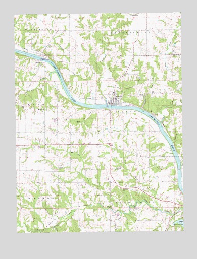
Bonaparte, IA USGS Topographic Map
Click on map above to begin viewing in our Map Viewer.

This topographic map contains these locations and features:
Feature Name Type Latitude Longitude GNIS ID View Map
Baker CreekStreamN40.7270°W91.7607°454325View Map
Bear CreekStreamN40.7170°W91.8446°454410View Map
BentonsportPopulated PlaceN40.7256°W91.8538°454522View Map
Bentonsport (historical)LocaleN40.7261°W91.8538°1980902View Map
Bentonsport Academy (historical)SchoolN40.7256°W91.8538°1980899View Map
Bentonsport BridgeBridgeN40.7256°W91.8541°1980903View Map
Bentonsport CemeteryCemeteryN40.7321°W91.8511°454523View Map
Bentonsport Post Office (historical)Post OfficeN40.7256°W91.8538°1980901View Map
Bentonsport Presbyterian ChurchChurchN40.7256°W91.8538°1980900View Map
Bentonsport River-Side County ParkParkN40.7250°W91.8538°463919View Map
Bentonsport Timber AreaParkN40.7278°W91.8516°1980855View Map
BonapartePopulated PlaceN40.6981°W91.8032°454744View Map
Bonaparte (historical)LocaleN40.7000°W91.8016°1980970View Map
Bonaparte Baptist ChurchChurchN40.7014°W91.8016°1980974View Map
Bonaparte CemeteryCemeteryN40.7013°W91.8090°1981038View Map
Bonaparte City HallBuildingN40.6981°W91.8029°1980968View Map
Bonaparte City ParkParkN40.6978°W91.8052°463598View Map
Bonaparte Fire DepartmentBuildingN40.6989°W91.8025°1980973View Map
Bonaparte Post OfficePost OfficeN40.6981°W91.8032°1980967View Map
Bonaparte Presbyterian ChurchChurchN40.6981°W91.8032°1980972View Map
Bonaparte Public LibraryBuildingN40.6986°W91.8016°1980969View Map
Bonaparte United Methodist ChurchChurchN40.6981°W91.8032°1980971View Map
Boyer (historical)LocaleN40.6375°W91.7863°1980894View Map
Boyer (historical)Post OfficeN40.6375°W91.7863°1980895View Map
Boyer CemeteryCemeteryN40.6381°W91.7871°454788View Map
Bradford CemeteryCemeteryN40.6956°W91.8532°454798View Map
Cave CemeteryCemeteryN40.6750°W91.7668°1981033View Map
Chapman CemeteryCemeteryN40.7125°W91.7727°1981036View Map
Christie CreekStreamN40.6970°W91.7921°455407View Map
City of BonaparteCivilN40.7012°W91.8005°2394217View Map
Coon CreekStreamN40.6280°W91.8461°455611View Map
Des Moines River AccessLocaleN40.6723°W91.7596°1980856View Map
Dulin CemeteryCemeteryN40.6282°W91.8289°456053View Map
Flatrock CreekStreamN40.6356°W91.7966°456630View Map
Harmony Elementary SchoolSchoolN40.7050°W91.8012°1980975View Map
Helwig CemeteryCemeteryN40.6536°W91.7991°457389View Map
Holsworth CemeteryCemeteryN40.7489°W91.7877°457569View Map
Honey CreekStreamN40.6978°W91.8068°457608View Map
Indian LakeLakeN40.6293°W91.7526°457803View Map
Indian Lake ParkParkN40.6300°W91.7504°457804View Map
Lena Post Office (historical)Post OfficeN40.6273°W91.8488°1980883View Map
LexingtonPopulated PlaceN40.6992°W91.8146°465349View Map
Lexington CreekStreamN40.6984°W91.8227°458311View Map
Lindsay Wilderness AreaReserveN40.7084°W91.7835°1980857View Map
Little Indian CreekStreamN40.6373°W91.7679°458472View Map
Mud CreekStreamN40.6956°W91.8146°459372View Map
Neumann CemeteryCemeteryN40.6611°W91.7996°459460View Map
New Lexington CemeteryCemeteryN40.7028°W91.8168°1981037View Map
Palestine (historical)Populated PlaceN40.6945°W91.7941°465350View Map
Potters BranchStreamN40.6950°W91.7816°460376View Map
Preen CemeteryCemeteryN40.6459°W91.8152°460436View Map
Reed's Creek CemeteryCemeteryN40.6917°W91.7585°1981035View Map
Reeds CreekStreamN40.6867°W91.7663°460575View Map
Rhodes CemeteryCemeteryN40.6620°W91.7663°460600View Map
Robb CemeteryCemeteryN40.6973°W91.8683°460690View Map
Slaughter CreekStreamN40.6756°W91.7577°461671View Map
Steinmeyer CemeteryCemeteryN40.6491°W91.7954°461985View Map
Thomas Rhodes Historical MarkerParkN40.7014°W91.8085°1980991View Map
Thomson CemeteryCemeteryN40.6623°W91.8438°462223View Map
Township of BonaparteCivilN40.6967°W91.7762°467472View Map
Township of FarmingtonCivilN40.6393°W91.7760°467825View Map
Van Buren County Hospital and ClinicHospitalN40.6981°W91.8032°1980966View Map
VernonPopulated PlaceN40.7225°W91.8552°462552View Map
Vernon CemeteryCemeteryN40.7236°W91.8599°1980997View Map
Vernon Post Office (historical)Post OfficeN40.7223°W91.8557°1980898View Map
Vernon School (historical)SchoolN40.7223°W91.8557°1980897View Map
White CemeteryCemeteryN40.7256°W91.7568°462977View Map
White Oak CreekStreamN40.6359°W91.7957°462989View Map
White Timber AreaParkN40.6431°W91.7821°1980854View Map
Willits Post Office (historical)Post OfficeN40.6273°W91.8488°1980882View Map
Wright CemeteryCemeteryN40.6406°W91.7541°463216View Map

Note: Coordinates in the location and feature list above are referenced to NAD83 datum.


Copyright (C) 2008-2024 Ryan Niemi / Sunset Dynamics ... All Rights Reserved