TopoQuest Logo
Do you find TopoQuest useful?
Help keep TopoQuest running and adding new maps/features by donating!
Bitcoin:  19c7KJd3qBynnjoSw5npx9KScwjBe4ifkT
Litecoin:  LXs6TkuXGGXo1vDsWCkWVdjQX94eUKd6ui
Home View Maps Find Maps Find Places Resources & Links


Waurika West, Oklahoma Topographic Map

USGS Map Title: Waurika West, OK
USGS Map MRC: 34098B1
DRG (GeoTIFF) Download: o34098b1.tif


Neighboring USGS Topographic Map Quads:


  Temple, OK  
34098C2
 

  Corum, OK  
34098C1
 

  Comanche, OK  
34097C8
 

  Hooper, OK  
34098B2
 

  Waurika West, OK  
34098B1
 

  Waurika East, OK  
34097B8
 

  Petrolia, TX  
34098A2
 

  Irving, OK  
34098A1
 

  Ryan, OK  
34097A8


Map MRC Location:

N35°
W99°
N35°
W98°
H8 H7 H6 H5 H4 H3 H2 H1
G8 G7 G6 G5 G4 G3 G2 G1
F8 F7 F6 F5 F4 F3 F2 F1
E8 E7 E6 E5 E4 E3 E2 E1
D8 D7 D6 D5 D4 D3 D2 D1
C8 C7 C6 C5 C4 C3 C2 C1
B8 B7 B6 B5 B4 B3 B2 B1
A8 A7 A6 A5 A4 A3 A2 A1
N34°
W99°
N34°
W98°

Waurika West, OK USGS 1:24K Topographic Map Preview:
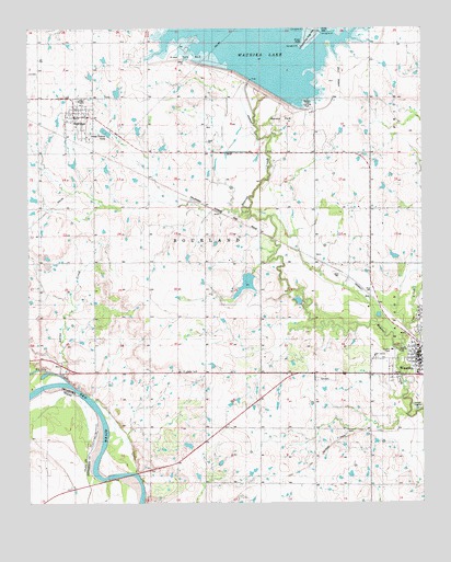
Waurika West, OK USGS Topographic Map
Click on map above to begin viewing in our Map Viewer.

This topographic map contains these locations and features:
Feature Name Type Latitude Longitude GNIS ID View Map
Beaver Creek Landing ParkParkN34.2301°W98.0364°1777807View Map
City of WaurikaCivilN34.1846°W98.0245°2412195View Map
Cow CreekStreamN34.1662°W98.0078°1091768View Map
HastingsPopulated PlaceN34.2268°W98.1100°1093597View Map
Hastings CemeteryCemeteryN34.2384°W98.1240°1093598View Map
Hastings Volunteer Fire DepartmentBuildingN34.2260°W98.1097°2658466View Map
Japanese Beaver Lake DamLakeN34.1828°W98.0563°1750891View Map
Jefferson County Airport (historical)AirportN34.2370°W98.0261°1102346View Map
Jefferson County JailBuildingN34.1658°W98.0020°2757835View Map
Jefferson County Sheriff's OfficeBuildingN34.1658°W98.0018°2757718View Map
Kiowa Park Number 2ParkN34.2431°W98.0753°1777809View Map
Moneka ParkParkN34.2265°W98.0448°1777808View Map
Oknoname 067001 DamDamN34.2384°W98.0920°1755887View Map
Oknoname 067001 ReservoirReservoirN34.2384°W98.0920°1755888View Map
Oknoname 067002 DamDamN34.1384°W98.0753°1755889View Map
Oknoname 067002 ReservoirReservoirN34.1384°W98.0753°1755890View Map
Oknoname 067003 DamDamN34.1768°W98.0386°1755891View Map
Oknoname 067003 ReservoirReservoirN34.1764°W98.0393°1755892View Map
Saline CreekStreamN34.1593°W98.1159°1097658View Map
State Highway 79 BridgeBridgeN34.1326°W98.0939°2031637View Map
Terral Sheriff's OfficeBuildingN34.1662°W98.0019°2757761View Map
Town of HastingsCivilN34.2243°W98.1087°2412733View Map
Township of BourlandCivilN34.1945°W98.0781°1825209View Map
Waurika CemeteryCemeteryN34.1581°W98.0317°1099440View Map
Waurika DamDamN34.2351°W98.0553°1754448View Map
Waurika Police DepartmentBuildingN34.1630°W98.0018°2757576View Map
Waurika Volunteer Fire DepartmentBuildingN34.1632°W98.0018°2658273View Map

Note: Coordinates in the location and feature list above are referenced to NAD83 datum.


Copyright (C) 2008-2024 Ryan Niemi / Sunset Dynamics ... All Rights Reserved