TopoQuest Logo
Do you find TopoQuest useful?
Help keep TopoQuest running and adding new maps/features by donating!
Bitcoin:  19c7KJd3qBynnjoSw5npx9KScwjBe4ifkT
Litecoin:  LXs6TkuXGGXo1vDsWCkWVdjQX94eUKd6ui
Home View Maps Find Maps Find Places Resources & Links


Wawayanda, New Jersey Topographic Map

USGS Map Title: Wawayanda, NJ
USGS Map MRC: 41074B4
DRG (GeoTIFF) Download: o41074b4.tif


Neighboring USGS Topographic Map Quads:


  Unionville, NY  
41074C5
 

  Pine Island, NY  
41074C4
 

  Warwick, NY  
41074C3
 

  Hamburg, NJ  
41074B5
 

  Wawayanda, NJ  
41074B4
 

  Greenwood Lake, NY  
41074B3
 

  Franklin, NJ  
41074A5
 

  Newfoundland, NJ  
41074A4
 

  Wanaque, NJ  
41074A3


Map MRC Location:

N42°
W75°
N42°
W74°
H8 H7 H6 H5 H4 H3 H2 H1
G8 G7 G6 G5 G4 G3 G2 G1
F8 F7 F6 F5 F4 F3 F2 F1
E8 E7 E6 E5 E4 E3 E2 E1
D8 D7 D6 D5 D4 D3 D2 D1
C8 C7 C6 C5 C4 C3 C2 C1
B8 B7 B6 B5 B4 B3 B2 B1
A8 A7 A6 A5 A4 A3 A2 A1
N41°
W75°
N41°
W74°

Wawayanda, NJ USGS 1:24K Topographic Map Preview:
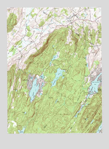
Wawayanda, NJ USGS Topographic Map
Click on map above to begin viewing in our Map Viewer.

This topographic map contains these locations and features:
Feature Name Type Latitude Longitude GNIS ID View Map
Barry LakesLakeN41.1984°W74.4388°874519View Map
Bearfort MountainSummitN41.1395°W74.3918°874604View Map
Bearfort WatersLakeN41.1449°W74.4069°874605View Map
Black CreekStreamN41.2194°W74.4785°874785View Map
Black Horse RanchLocaleN41.2478°W74.4769°2516023View Map
Blooms CornersLocaleN41.2487°W74.4371°944293View Map
Cherry RidgeLocaleN41.1607°W74.4454°875396View Map
Cherry Ridge BrookStreamN41.1404°W74.4665°875397View Map
Cutler FarmsLocaleN41.2425°W74.4067°2559686View Map
DeKaysPopulated PlaceN41.2304°W74.4404°875823View Map
District School Number 8SchoolN41.2368°W74.4124°948487View Map
Double KillStreamN41.2383°W74.4207°973972View Map
East Highland LakeReservoirN41.1721°W74.4532°876053View Map
East Highland Lake DamDamN41.1758°W74.4518°884343View Map
Glenwood CemeteryCemeteryN41.2443°W74.4782°876640View Map
Glenwood SchoolSchoolN41.2482°W74.4982°876643View Map
Greenwood ChurchChurchN41.1657°W74.3921°876817View Map
Highland LakeReservoirN41.1840°W74.4607°877105View Map
Highland Lake DamDamN41.1840°W74.4607°884345View Map
Highland LakesPopulated PlaceN41.1773°W74.4688°877106View Map
Highland Lakes Census Designated PlaceCensusN41.1716°W74.4643°2389926View Map
Highland Lakes Fire DepartmentBuildingN41.1805°W74.4570°2614430View Map
KampePopulated PlaceN41.1670°W74.4563°877512View Map
Kingdom Hall of Jehovah's WitnessesChurchN41.2371°W74.4167°2714695View Map
Kohout LakeReservoirN41.1925°W74.3935°877610View Map
Kohout Lake DamDamN41.1940°W74.3935°884347View Map
Lake LookoutLakeN41.1571°W74.4345°877935View Map
Lake WandaLakeN41.1817°W74.4531°881522View Map
Lake Wanda DamDamN41.1818°W74.4513°884346View Map
Laurel PondLakeN41.1813°W74.4248°877689View Map
Leeper PondLakeN41.1540°W74.3941°877729View Map
Livingston PondsLakeN41.2082°W74.4363°877877View Map
Lookover LakeReservoirN41.1504°W74.3957°877936View Map
Lookover Lake DamDamN41.1504°W74.3957°884350View Map
Maple GrangeLocaleN41.2165°W74.4646°878092View Map
Maple HillSummitN41.2048°W74.3818°878095View Map
Marshall PondLakeN41.1458°W74.4760°878144View Map
Mastodon LakeLakeN41.1682°W74.4875°878180View Map
MoePopulated PlaceN41.1623°W74.3865°878424View Map
Mount Laurel LakeReservoirN41.1619°W74.3925°878555View Map
Mount Laurel Lake DamDamN41.1632°W74.3913°884349View Map
New MilfordPopulated PlaceN41.2345°W74.4138°958437View Map
New Milford and Edenville United Methodist ChurchChurchN41.2347°W74.4158°2714696View Map
New Milford Post OfficePost OfficeN41.2344°W74.4165°2713516View Map
Parker LakeReservoirN41.1996°W74.3952°879127View Map
Penningtons OrchardLocaleN41.2328°W74.3842°2440572View Map
Prices SwitchLocaleN41.2243°W74.4549°879487View Map
Rough Mountain State ForestForestN41.1679°W74.3768°879834View Map
Sanfordville Elementary SchoolSchoolN41.2428°W74.3903°2440571View Map
Sawmill Pond BrookStreamN41.1720°W74.3896°880277View Map
Terrace PondLakeN41.1390°W74.3947°881138View Map
Township of VernonCivilN41.1974°W74.4858°882258View Map
Township of West Milford Fire Department Upper Greenwood Lake Company 5BuildingN41.1817°W74.3881°2614520View Map
Upper Greenwood LakePopulated PlaceN41.1818°W74.3821°881385View Map
Upper Greenwood LakeReservoirN41.1747°W74.3809°881386View Map
Upper Greenwood Lake Volunteer Ambulance CorpsBuildingN41.1844°W74.3894°2659796View Map
Upper Highland LakeReservoirN41.1801°W74.4671°881387View Map
Upper Highland Lake DamDamN41.1787°W74.4674°884344View Map
UttertownPopulated PlaceN41.1268°W74.4163°881400View Map
VernonPopulated PlaceN41.1984°W74.4832°881443View Map
Vernon Township Ambulance SquadBuildingN41.1951°W74.4928°2660245View Map
Vernon Township Fire DepartmentBuildingN41.1974°W74.4851°2613827View Map
Vernon Township Fire Department OfficeBuildingN41.2023°W74.4837°2613812View Map
Vernon Township Police DepartmentBuildingN41.2022°W74.4837°2730916View Map
Vernon ValleyPopulated PlaceN41.2368°W74.4871°1867377View Map
Vernon Valley Census Designated PlaceCensusN41.2396°W74.4834°2390429View Map
Vernon Valley LakeReservoirN41.2284°W74.4866°883154View Map
Warwick Drive-InLocaleN41.2350°W74.3797°2438629View Map
Warwick Shopping CenterLocaleN41.2361°W74.3811°2440573View Map
WawayandaPopulated PlaceN41.1879°W74.4257°881630View Map
Wawayanda CreekStreamN41.2293°W74.4734°970752View Map
Wawayanda LakeReservoirN41.1815°W74.4334°881632View Map
Wawayanda Lake DamDamN41.1868°W74.4229°884348View Map
Wawayanda MountainSummitN41.1976°W74.4571°881633View Map
Wawayanda State ParkParkN41.1834°W74.4496°883064View Map
Willow BrookPopulated PlaceN41.2107°W74.3838°881854View Map

Note: Coordinates in the location and feature list above are referenced to NAD83 datum.


Copyright (C) 2008-2025 Ryan Niemi / Sunset Dynamics ... All Rights Reserved