TopoQuest Logo
Do you find TopoQuest useful?
Help keep TopoQuest running and adding new maps/features by donating!
Bitcoin:  19c7KJd3qBynnjoSw5npx9KScwjBe4ifkT
Litecoin:  LXs6TkuXGGXo1vDsWCkWVdjQX94eUKd6ui
Home View Maps Find Maps Find Places Resources & Links


Weatherford, Oklahoma Topographic Map

USGS Map Title: Weatherford, OK
USGS Map MRC: 35098E6
DRG (GeoTIFF) Download: o35098e6.tif


Neighboring USGS Topographic Map Quads:


  Clinton NE, OK  
35098F7
 

  Weatherford NW, OK  
35098F6
 

  Squaw Creek, OK  
35098F5
 

  Indianapolis, OK  
35098E7
 

  Weatherford, OK  
35098E6
 

  Hydro, OK  
35098E5
 

  Corn, OK  
35098D7
 

  Crowder Lake, OK  
35098D6
 

  Eakly NE, OK  
35098D5


Map MRC Location:

N36°
W99°
N36°
W98°
H8 H7 H6 H5 H4 H3 H2 H1
G8 G7 G6 G5 G4 G3 G2 G1
F8 F7 F6 F5 F4 F3 F2 F1
E8 E7 E6 E5 E4 E3 E2 E1
D8 D7 D6 D5 D4 D3 D2 D1
C8 C7 C6 C5 C4 C3 C2 C1
B8 B7 B6 B5 B4 B3 B2 B1
A8 A7 A6 A5 A4 A3 A2 A1
N35°
W99°
N35°
W98°

Weatherford, OK USGS 1:24K Topographic Map Preview:
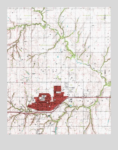
Weatherford, OK USGS Topographic Map
Click on map above to begin viewing in our Map Viewer.

This topographic map contains these locations and features:
Feature Name Type Latitude Longitude GNIS ID View Map
Bradley CemeteryCemeteryN35.5808°W98.6852°1090448View Map
Buckmaster DamDamN35.5067°W98.6920°1755516View Map
Burcham Elementary SchoolSchoolN35.5417°W98.6865°1777802View Map
Catholic Parish HallChurchN35.5323°W98.6990°1790108View Map
Cedar ChurchChurchN35.6095°W98.6506°1091064View Map
Church of ChristChurchN35.5384°W98.6845°1790109View Map
Church of the NazareneChurchN35.5273°W98.7112°1790110View Map
City of WeatherfordCivilN35.5384°W98.6872°2412198View Map
Dead Women CrossingPopulated PlaceN35.5678°W98.6509°1100345View Map
Emmanuel Baptist ChurchChurchN35.5331°W98.7006°1790111View Map
Federated ChurchChurchN35.5284°W98.7081°1790112View Map
First Assembly of God ChurchChurchN35.5414°W98.6776°1790113View Map
First Baptist ChurchChurchN35.5367°W98.6926°1790115View Map
First United Methodist ChurchChurchN35.5348°W98.7131°1790117View Map
Grace Lutheran ChurchChurchN35.5301°W98.7081°1790116View Map
Greenwood CemeteryCemeteryN35.5340°W98.7209°1093400View Map
Hunnicutt DamDamN35.5001°W98.6770°1755490View Map
Hunnicutt ReservoirReservoirN35.5002°W98.6765°1755491View Map
Johnston DamDamN35.5134°W98.6503°1755488View Map
Johnston ReservoirReservoirN35.5134°W98.6503°1755489View Map
KBXR-FM (Weatherford)TowerN35.5506°W98.7334°1102830View Map
KWEY-AM (Weatherford)TowerN35.5592°W98.7201°1102780View Map
Laughlin DamDamN35.6067°W98.6554°1752407View Map
Laughlin LakeReservoirN35.6067°W98.6554°1752408View Map
Little Deep CreekStreamN35.5487°W98.6320°1094752View Map
Northpark ShopsLocaleN35.5373°W98.6945°1763845View Map
Pine Acres Mennonite ChurchChurchN35.5389°W98.6865°1790114View Map
Rader ParkParkN35.5603°W98.6756°1777803View Map
Restoration ChurchChurchN35.5273°W98.7084°1790118View Map
Saint Eugene Catholic ChurchChurchN35.5331°W98.6976°1790120View Map
Saint Marks Episcopal ChurchChurchN35.5314°W98.7184°1790121View Map
Sinor Emergency Medical Services WeatherfordBuildingN35.5274°W98.7043°2695874View Map
Southwestern Christian ChurchChurchN35.5289°W98.6898°1790119View Map
Southwestern Oklahoma State UniversitySchoolN35.5356°W98.7074°1777805View Map
Southwestern Oklahoma State University Department of Public SafetyBuildingN35.5343°W98.7071°2757903View Map
Southwestern State CollegeSchoolN35.5351°W98.7076°1098327View Map
Sportsman LakeReservoirN35.5040°W98.6917°1098365View Map
Thomas P Stafford AirportAirportN35.5447°W98.6700°1102733View Map
Township of CedarCivilN35.5639°W98.7087°1825505View Map
WeatherfordPopulated PlaceN35.5262°W98.7076°1099451View Map
Weatherford Ambulance ServiceBuildingN35.5270°W98.7048°2658362View Map
Weatherford DivisionCivilN35.5547°W98.7406°1937908View Map
Weatherford East Elementary SchoolSchoolN35.5305°W98.6992°1092440View Map
Weatherford Fire DepartmentBuildingN35.5275°W98.6995°2658406View Map
Weatherford High SchoolSchoolN35.5413°W98.6928°1819457View Map
Weatherford Middle SchoolSchoolN35.5302°W98.7080°1098867View Map
Weatherford Police DepartmentBuildingN35.5246°W98.7137°2757493View Map
Weatherford Regional HospitalHospitalN35.5393°W98.6622°2695784View Map
Weatherford Shopping CenterLocaleN35.5381°W98.6945°1763846View Map
Weatherford West Elementary SchoolSchoolN35.5316°W98.7171°1099606View Map
Weber ParkParkN35.5342°W98.6929°1777804View Map
Wesley Foundation ChurchChurchN35.5348°W98.7123°1790122View Map

Note: Coordinates in the location and feature list above are referenced to NAD83 datum.


Copyright (C) 2008-2025 Ryan Niemi / Sunset Dynamics ... All Rights Reserved