TopoQuest Logo
Do you find TopoQuest useful?
Help keep TopoQuest running and adding new maps/features by donating!
Bitcoin:  19c7KJd3qBynnjoSw5npx9KScwjBe4ifkT
Litecoin:  LXs6TkuXGGXo1vDsWCkWVdjQX94eUKd6ui
Home View Maps Find Maps Find Places Resources & Links


Weeks, Louisiana Topographic Map

USGS Map Title: Weeks, LA
USGS Map MRC: 29091G7
DRG (GeoTIFF) Download: o29091g7.tif


Neighboring USGS Topographic Map Quads:


  Delcambre, LA  
29091H8
 

  New Iberia South, LA  
29091H7
 

  Jeanerette, LA  
29091H6
 

  Tigre Lagoon, LA  
29091G8
 

  Weeks, LA  
29091G7
 

  Kemper, LA  
29091G6
 

  Cypremort Point, LA  
29091F8
 

  Hammock Lake, LA  
29091F7
 

  Marone Point, LA  
29091F6


Map MRC Location:

N30°
W92°
N30°
W91°
H8 H7 H6 H5 H4 H3 H2 H1
G8 G7 G6 G5 G4 G3 G2 G1
F8 F7 F6 F5 F4 F3 F2 F1
E8 E7 E6 E5 E4 E3 E2 E1
D8 D7 D6 D5 D4 D3 D2 D1
C8 C7 C6 C5 C4 C3 C2 C1
B8 B7 B6 B5 B4 B3 B2 B1
A8 A7 A6 A5 A4 A3 A2 A1
N29°
W92°
N29°
W91°

Weeks, LA USGS 1:24K Topographic Map Preview:
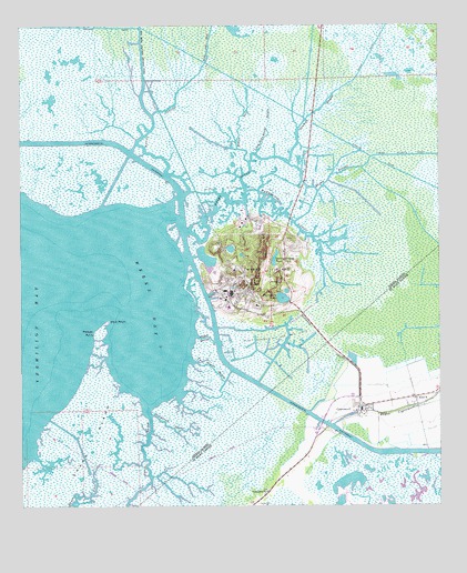
Weeks, LA USGS Topographic Map
Click on map above to begin viewing in our Map Viewer.

This topographic map contains these locations and features:
Feature Name Type Latitude Longitude GNIS ID View Map
Alice BPopulated PlaceN29.7763°W91.7571°559760View Map
Bayou CarlinStreamN29.8308°W91.8262°532484View Map
Bayou CypremortStreamN29.7710°W91.7821°559925View Map
Bayou GarrettStreamN29.7952°W91.8232°532603View Map
Bayou PatoutGutN29.8397°W91.7951°532710View Map
Bayou PeteStreamN29.8433°W91.8101°532714View Map
Bayou PirreBayN29.7522°W91.8577°532724View Map
CypremortPopulated PlaceN29.7749°W91.7746°560562View Map
Cypremort PrairieAreaN29.7780°W91.7626°551435View Map
Ewing CemeteryCemeteryN29.7508°W91.8043°560723View Map
Four Corners Volunteer Fire Department Station 4BuildingN29.7766°W91.7565°2691863View Map
Long Ride Barge BayouStreamN29.8419°W91.8046°536712View Map
Louisa BridgeBridgeN29.7720°W91.7852°2601255View Map
Mud PointCapeN29.7994°W91.8485°542214View Map
Patout Bayou BridgeBridgeN29.8343°W91.7903°2601259View Map
Pelican PointCapeN29.7972°W91.8543°538056View Map
Pentecostal ChurchChurchN29.7538°W91.8018°1627897View Map
Plantation LakeLakeN29.8041°W91.7970°555674View Map
Port of West Saint MaryLocaleN29.7733°W91.7585°1628549View Map
Sandy Bottom PondLakeN29.8146°W91.7991°555973View Map
Shark IslandIslandN29.7613°W91.8562°539295View Map
Sheephead BayouBayN29.7694°W91.8287°539312View Map
Stumpy BayouStreamN29.8397°W91.7951°539703View Map
Two Mouth BayouStreamN29.7885°W91.8251°540069View Map
Warehouse BayouGutN29.8263°W91.7954°540234View Map
WeeksPopulated PlaceN29.8077°W91.8071°540279View Map
Weeks BayBayN29.8035°W91.8362°540280View Map
Weeks Bay ChannelBayN29.8347°W91.8467°540672View Map
Weeks BayouGutN29.8347°W91.8087°540281View Map
Weeks IslandIslandN29.8110°W91.8046°556379View Map
Weeks Island Oil and Gas FieldOilfieldN29.8335°W91.8015°540284View Map

Note: Coordinates in the location and feature list above are referenced to NAD83 datum.


Copyright (C) 2008-2025 Ryan Niemi / Sunset Dynamics ... All Rights Reserved