TopoQuest Logo
Do you find TopoQuest useful?
Help keep TopoQuest running and adding new maps/features by donating!
Bitcoin:  19c7KJd3qBynnjoSw5npx9KScwjBe4ifkT
Litecoin:  LXs6TkuXGGXo1vDsWCkWVdjQX94eUKd6ui
Home View Maps Find Maps Find Places Resources & Links


Wellington, Alabama Topographic Map

USGS Map Title: Wellington, AL
USGS Map MRC: 33085G8
DRG (GeoTIFF) Download: o33085g8.tif


Neighboring USGS Topographic Map Quads:


  Dunaway Mountain, AL  
33086H1
 

  Glencoe, AL  
33085H8
 

  Colvin Gap, AL  
33085H7
 

  Ohatchee, AL  
33086G1
 

  Wellington, AL  
33085G8
 

  Jacksonville West, AL  
33085G7
 

  Francis Mill, AL  
33086F1
 

  Eulaton, AL  
33085F8
 

  Anniston, AL  
33085F7


Map MRC Location:

N34°
W86°
N34°
W85°
H8 H7 H6 H5 H4 H3 H2 H1
G8 G7 G6 G5 G4 G3 G2 G1
F8 F7 F6 F5 F4 F3 F2 F1
E8 E7 E6 E5 E4 E3 E2 E1
D8 D7 D6 D5 D4 D3 D2 D1
C8 C7 C6 C5 C4 C3 C2 C1
B8 B7 B6 B5 B4 B3 B2 B1
A8 A7 A6 A5 A4 A3 A2 A1
N33°
W86°
N33°
W85°

Wellington, AL USGS 1:24K Topographic Map Preview:
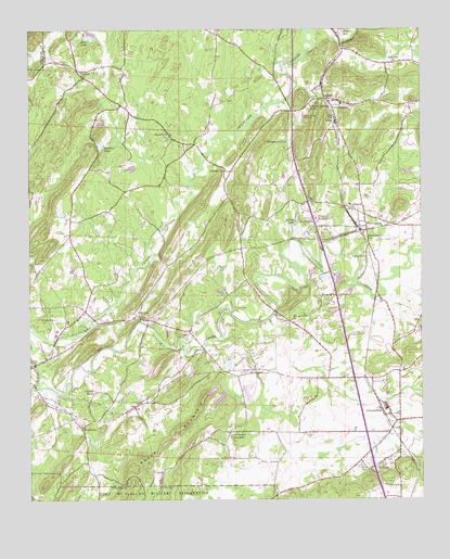
Wellington, AL USGS Topographic Map
Click on map above to begin viewing in our Map Viewer.

This topographic map contains these locations and features:
Feature Name Type Latitude Longitude GNIS ID View Map
AlexandriaPopulated PlaceN33.7740°W85.8855°157876View Map
Alexandria Baptist ChurchChurchN33.7726°W85.8855°140785View Map
Alexandria CemeteryCemeteryN33.7729°W85.8825°149161View Map
Alexandria Census Designated PlaceCensusN33.7675°W85.8792°2402638View Map
Alexandria Church of GodChurchN33.7695°W85.9347°149162View Map
Alexandria CreekStreamN33.7907°W85.9447°112986View Map
Alexandria Fire DepartmentBuildingN33.7714°W85.8818°2682982View Map
Alexandria High SchoolSchoolN33.7743°W85.8864°140786View Map
Alexandria Post OfficePost OfficeN33.7676°W85.8919°2789093View Map
Alexandria SpringSpringN33.7701°W85.8825°149291View Map
Alexandria United Methodist ChurchChurchN33.7690°W85.8827°140787View Map
Alexandria ValleyValleyN33.7918°W85.9444°149163View Map
Alexandria-Webster Chapel DivisionCivilN33.8471°W85.8932°165679View Map
Battle CreekStreamN33.7834°W85.9283°140803View Map
Beasley (historical)Populated PlaceN33.7576°W85.9816°140804View Map
Bells DamDamN33.8723°W85.9791°131789View Map
Bells LakeReservoirN33.8728°W85.9806°113893View Map
BethelPopulated PlaceN33.8640°W85.9847°140806View Map
Bethel Methodist ChurchChurchN33.8623°W85.9833°114071View Map
Big Oak Community Volunteer Fire DepartmentBuildingN33.8721°W85.9872°2682653View Map
Big Oak DamDamN33.8734°W85.9800°131790View Map
Big Oak LakeReservoirN33.8740°W85.9798°131791View Map
Bobs CreekStreamN33.7651°W85.8980°149166View Map
Boozers LakeLakeN33.8226°W85.9225°140818View Map
Boyd Spring BranchStreamN33.7843°W85.9086°149168View Map
Brook MountainSummitN33.7582°W85.9666°114948View Map
Chalybeate MountainSummitN33.7648°W85.9489°149172View Map
Chigger Ridge (historical)Populated PlaceN33.7843°W85.9519°140833View Map
Circle H SpringSpringN33.8240°W85.9236°149296View Map
Clark (historical)Populated PlaceN33.7765°W85.9319°149173View Map
Coley DamDamN33.8104°W85.9044°131757View Map
Coley DamDamN33.8118°W85.8916°131758View Map
Coley LakeReservoirN33.8096°W85.9055°131756View Map
Crooks CemeteryCemeteryN33.7837°W85.9333°116891View Map
Crystal SpringsPopulated PlaceN33.8568°W85.9083°140857View Map
Crystal SpringsSpringN33.8557°W85.9091°149298View Map
Crystal Springs CemeteryCemeteryN33.8568°W85.9091°149177View Map
Crystal Springs LakeReservoirN33.8554°W85.9093°116942View Map
Crystal Springs SpeedwayLocaleN33.8518°W85.9144°164312View Map
Donner DamDamN33.8334°W85.9666°131767View Map
Donner LakeReservoirN33.8334°W85.9666°131768View Map
DukePopulated PlaceN33.8507°W85.9025°117641View Map
Duke Junior High SchoolSchoolN33.8543°W85.9002°140862View Map
Duke Missionary Baptist ChurchChurchN33.8534°W85.9019°140861View Map
Easterwood BranchStreamN33.7804°W85.9050°149180View Map
Ebenezer Baptist ChurchChurchN33.7970°W85.9683°140865View Map
Fairview Missionary Baptist ChurchChurchN33.8659°W85.8836°118143View Map
Farm Service Agency Interest of AlabamaParkN33.8082°W85.9233°2776752View Map
Gladden CemeteryCemeteryN33.7670°W85.9122°119014View Map
GraytonPopulated PlaceN33.8001°W85.9672°156432View Map
Grayton Junior High SchoolSchoolN33.7987°W85.9666°140908View Map
Havers CreekStreamN33.8237°W85.9569°149183View Map
Hebron (historical)Populated PlaceN33.8362°W85.9369°140913View Map
Hebron Baptist ChurchChurchN33.8373°W85.9389°119928View Map
Hebron CemeteryCemeteryN33.8390°W85.9414°149184View Map
Hebron SpringsSpringN33.8359°W85.9383°149305View Map
Hebron Station (historical)LocaleN33.8157°W85.9389°149185View Map
Hill Top (historical)Populated PlaceN33.8334°W85.8944°149186View Map
Hopewell ChurchChurchN33.8193°W85.8925°120381View Map
Ingram WellsPopulated PlaceN33.7793°W85.9794°156515View Map
Kellys DamDamN33.8203°W85.9160°131762View Map
Kellys LakeReservoirN33.8220°W85.9153°151946View Map
LaneyPopulated PlaceN33.8565°W85.9055°121377View Map
Linders Spring BranchStreamN33.8037°W85.8869°149195View Map
Lowrimores CrossroadsPopulated PlaceN33.7679°W85.9364°122091View Map
Martins CrossroadsLocaleN33.7843°W85.9383°166223View Map
Martins Crossroads Post OfficePost OfficeN33.7843°W85.9383°169283View Map
McCullars (historical)Populated PlaceN33.7993°W85.9080°149198View Map
McCullars Lake Number 1ReservoirN33.7769°W85.9392°131740View Map
McCullars Lake Number TwoReservoirN33.7863°W85.9366°131745View Map
McCullars Number 1 DamDamN33.7784°W85.9366°131739View Map
McCullars Number 2 DamDamN33.7873°W85.9358°131744View Map
McCullars SpringSpringN33.7754°W85.9336°149308View Map
MelrosePopulated PlaceN33.7590°W85.8900°158013View Map
MiddletonPopulated PlaceN33.7698°W85.9847°156704View Map
Middleton CemeteryCemeteryN33.7701°W85.9836°149199View Map
Mount View Missionary Baptist ChurchChurchN33.7979°W85.9166°123414View Map
Mount Zion Baptist ChurchChurchN33.7579°W85.8925°140975View Map
Mount Zion CemeteryCemeteryN33.7579°W85.8925°140976View Map
Nunally DamDamN33.8439°W85.9760°131771View Map
Oak Bowery Missionary Baptist ChurchChurchN33.7695°W85.9839°140992View Map
Ohatchee Missionary Baptist ChurchChurchN33.7984°W85.9964°124186View Map
Ohatchee MountainsRangeN33.8293°W85.9458°149207View Map
Ohatchee QuarryMineN33.7789°W85.9294°2568272View Map
Peeks Hill (historical)Populated PlaceN33.8457°W85.9533°141001View Map
Peeks Hill United Methodist ChurchChurchN33.8473°W85.9558°152866View Map
Point CalhounSummitN33.7654°W85.9847°149170View Map
Reads MillPopulated PlaceN33.8732°W85.9016°156947View Map
Reads SpringSpringN33.8720°W85.8980°149309View Map
Rock Pile MountainSummitN33.7782°W85.9436°141020View Map
Rudd (historical)Populated PlaceN33.8029°W85.8902°166226View Map
Rudd Post Office (historical)Post OfficeN33.8029°W85.8902°169306View Map
S D Walker Nursery FarmsLocaleN33.8031°W85.8883°2581953View Map
Samplers LakeReservoirN33.8453°W85.9171°126284View Map
Saxon DamDamN33.8084°W85.9000°131755View Map
Saxons LakeReservoirN33.8089°W85.9013°131754View Map
Shiloh Primitive Baptist ChurchChurchN33.8565°W85.9077°141039View Map
Tallaseehatchee (historical)Populated PlaceN33.7823°W85.9091°141048View Map
Tallasseehatchee CreekStreamN33.7801°W85.9977°158936View Map
Thrasher DamDamN33.8584°W85.9750°131779View Map
Thrasher LakeReservoirN33.8584°W85.9750°131780View Map
UnionPopulated PlaceN33.8154°W85.8902°141056View Map
Union Methodist ChurchChurchN33.8145°W85.8930°153770View Map
Virgil CreekStreamN33.8469°W85.9381°149220View Map
Welikee LakeReservoirN33.8442°W85.9771°153921View Map
WellingtonPopulated PlaceN33.8226°W85.8927°128732View Map
Wellington Baptist ChurchChurchN33.8270°W85.8972°158177View Map
Wellington ChurchChurchN33.8248°W85.9122°128733View Map
Wellington Post OfficePost OfficeN33.8224°W85.9077°2788936View Map
West WellingtonPopulated PlaceN33.8248°W85.9100°128805View Map
White Willow SpringSpringN33.7848°W85.9041°149315View Map
Woodruff (historical)Populated PlaceN33.8140°W85.8922°149224View Map
Youngblood GapGapN33.7826°W85.9569°149225View Map

Note: Coordinates in the location and feature list above are referenced to NAD83 datum.


Copyright (C) 2008-2024 Ryan Niemi / Sunset Dynamics ... All Rights Reserved