TopoQuest Logo
Do you find TopoQuest useful?
Help keep TopoQuest running and adding new maps/features by donating!
Bitcoin:  19c7KJd3qBynnjoSw5npx9KScwjBe4ifkT
Litecoin:  LXs6TkuXGGXo1vDsWCkWVdjQX94eUKd6ui
Home View Maps Find Maps Find Places Resources & Links


West Danby, New York Topographic Map

USGS Map Title: West Danby, NY
USGS Map MRC: 42076C5
DRG (GeoTIFF) Download: o42076c5.tif


Neighboring USGS Topographic Map Quads:


  Mecklenburg, NY  
42076D6
 

  Ithaca West, NY  
42076D5
 

  Ithaca East, NY  
42076D4
 

  Alpine, NY  
42076C6
 

  West Danby, NY  
42076C5
 

  Willseyville, NY  
42076C4
 

  Erin, NY  
42076B6
 

  Van Etten, NY  
42076B5
 

  Spencer, NY  
42076B4


Map MRC Location:

N43°
W77°
N43°
W76°
H8 H7 H6 H5 H4 H3 H2 H1
G8 G7 G6 G5 G4 G3 G2 G1
F8 F7 F6 F5 F4 F3 F2 F1
E8 E7 E6 E5 E4 E3 E2 E1
D8 D7 D6 D5 D4 D3 D2 D1
C8 C7 C6 C5 C4 C3 C2 C1
B8 B7 B6 B5 B4 B3 B2 B1
A8 A7 A6 A5 A4 A3 A2 A1
N42°
W77°
N42°
W76°

West Danby, NY USGS 1:24K Topographic Map Preview:
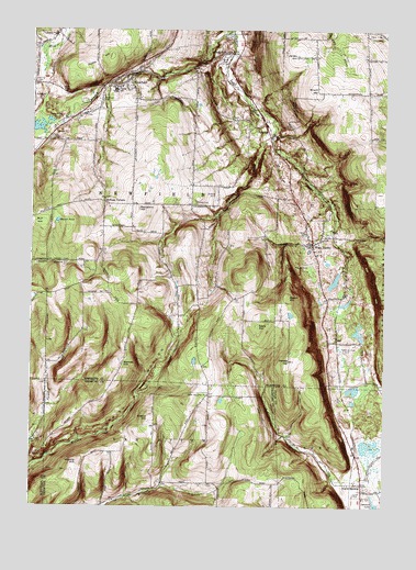
West Danby, NY USGS Topographic Map
Click on map above to begin viewing in our Map Viewer.

This topographic map contains these locations and features:
Feature Name Type Latitude Longitude GNIS ID View Map
Alexander CemeteryCemeteryN42.3292°W76.5628°947968View Map
Baptist CemeteryCemeteryN42.3638°W76.5888°2514993View Map
Barnes HillSummitN42.2876°W76.5922°943048View Map
Beaver PondLakeN42.3248°W76.6158°943432View Map
Beech HillSummitN42.3054°W76.5341°943506View Map
Benjamin HillSummitN42.3281°W76.5880°943662View Map
Bible Baptist ChurchChurchN42.2560°W76.5069°2598055View Map
Bible Baptist ChurchChurchN42.2561°W76.5072°2507543View Map
Bruce HillSummitN42.3592°W76.5238°944967View Map
Bull HillSummitN42.3245°W76.6238°969925View Map
Cloverland ParkPopulated PlaceN42.3281°W76.5906°2514391View Map
Danby Fire District - West Danby Volunteer Fire DepartmentBuildingN42.3133°W76.5287°2735433View Map
Dassance CemeteryCemeteryN42.3140°W76.6126°2514991View Map
Dawes HillSummitN42.2881°W76.5336°948078View Map
Elston HillSummitN42.2734°W76.5824°949612View Map
Elston Hill CemeteryCemeteryN42.2710°W76.5812°2514408View Map
First Baptist ChurchChurchN42.3627°W76.5897°2598063View Map
First Baptist ChurchChurchN42.3277°W76.5288°2598064View Map
Hine Family CemeteryCemeteryN42.3059°W76.5870°2514992View Map
Huddle HillSummitN42.2617°W76.6077°953384View Map
Hulburt HollowValleyN42.2568°W76.5129°953420View Map
Indian Creek Fruit FarmLocaleN42.3514°W76.5644°2518805View Map
Jersey HillSummitN42.3684°W76.5316°954016View Map
Kellogg CornersLocaleN42.3298°W76.5997°954456View Map
Larue CemeteryCemeteryN42.2797°W76.5621°2514409View Map
Littletree OrchardsLocaleN42.3514°W76.5644°2514927View Map
Mandeville FarmLocaleN42.2675°W76.5122°2516999View Map
McCorn CreekStreamN42.2592°W76.6249°956747View Map
NewfieldPopulated PlaceN42.3620°W76.5908°958510View Map
Newfield BridgeBridgeN42.3630°W76.5904°2419904View Map
Newfield Elementary SchoolSchoolN42.3580°W76.5968°2598040View Map
Newfield Hamlet Census Designated PlaceCensusN42.3583°W76.5923°2389549View Map
Newfield Post OfficePost OfficeN42.3594°W76.6001°2599272View Map
Newfield Public LibraryBuildingN42.3619°W76.5915°2599295View Map
Newfield Senior High SchoolSchoolN42.3591°W76.5952°946288View Map
Newfield StationLocaleN42.3687°W76.5549°958513View Map
Newfield Town HallBuildingN42.3627°W76.5897°2599305View Map
Newfield United Methodist ChurchChurchN42.3603°W76.5937°2598073View Map
North SpencerPopulated PlaceN42.2559°W76.5074°958926View Map
North Spencer CemeteryCemeteryN42.2525°W76.5049°2507551View Map
North Spencer Christian AcademySchoolN42.2561°W76.5069°2507544View Map
North Van Etten ChurchChurchN42.2792°W76.5619°958937View Map
Peoples Baptist ChurchChurchN42.3553°W76.6018°2598075View Map
Protts HillSummitN42.3648°W76.6069°961205View Map
Sebring CemeteryCemeteryN42.3608°W76.6234°964759View Map
Seely HillSummitN42.2976°W76.5444°964805View Map
Shelter Valley Mobile Home ParkPopulated PlaceN42.3667°W76.5572°2514394View Map
Stoneybrook FarmLocaleN42.3461°W76.5694°2514925View Map
StrattonPopulated PlaceN42.3470°W76.5411°966625View Map
Tom N' Jerry AirportAirportN42.3549°W76.5162°977978View Map
Town of NewfieldCivilN42.3376°W76.6130°979263View Map
Valley View CemeteryCemeteryN42.3223°W76.5283°2514996View Map
VanBuskirk GulfValleyN42.3467°W76.5419°968441View Map
West DanbyPopulated PlaceN42.3190°W76.5255°969202View Map
West Danby Methodist CemeteryCemeteryN42.3187°W76.5258°2514997View Map
WHCU-AM (Ithaca)TowerN42.3637°W76.6052°978438View Map
Woodlawn CemeteryCemeteryN42.3566°W76.6015°971669View Map

Note: Coordinates in the location and feature list above are referenced to NAD83 datum.


Copyright (C) 2008-2024 Ryan Niemi / Sunset Dynamics ... All Rights Reserved