TopoQuest Logo
Do you find TopoQuest useful?
Help keep TopoQuest running and adding new maps/features by donating!
Bitcoin:  19c7KJd3qBynnjoSw5npx9KScwjBe4ifkT
Litecoin:  LXs6TkuXGGXo1vDsWCkWVdjQX94eUKd6ui
Home View Maps Find Maps Find Places Resources & Links


West Point, Alabama Topographic Map

USGS Map Title: West Point, AL
USGS Map MRC: 34086B8
DRG (GeoTIFF) Download: o34086b8.tif


Neighboring USGS Topographic Map Quads:


  Massey, AL  
34087C1
 

  Falkville, AL  
34086C8
 

  Eva, AL  
34086C7
 

  Jones Chapel, AL  
34087B1
 

  West Point, AL  
34086B8
 

  Cullman, AL  
34086B7
 

  Crane Hill, AL  
34087A1
 

  Trimble, AL  
34086A8
 

  Hanceville, AL  
34086A7


Map MRC Location:

N35°
W87°
N35°
W86°
H8 H7 H6 H5 H4 H3 H2 H1
G8 G7 G6 G5 G4 G3 G2 G1
F8 F7 F6 F5 F4 F3 F2 F1
E8 E7 E6 E5 E4 E3 E2 E1
D8 D7 D6 D5 D4 D3 D2 D1
C8 C7 C6 C5 C4 C3 C2 C1
B8 B7 B6 B5 B4 B3 B2 B1
A8 A7 A6 A5 A4 A3 A2 A1
N34°
W87°
N34°
W86°

West Point, AL USGS 1:24K Topographic Map Preview:
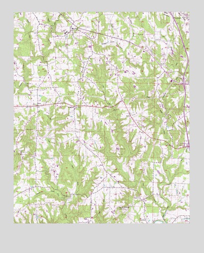
West Point, AL USGS Topographic Map
Click on map above to begin viewing in our Map Viewer.

This topographic map contains these locations and features:
Feature Name Type Latitude Longitude GNIS ID View Map
Alvis BranchStreamN34.2237°W86.8836°113060View Map
Ames School (historical)SchoolN34.1676°W86.9950°134847View Map
BaldwinPopulated PlaceN34.1893°W86.9169°113408View Map
Baldwin Chapel CemeteryCemeteryN34.1895°W86.9150°1805417View Map
Baldwin Chapel Cumberland Presbyterian ChurchChurchN34.1890°W86.9150°134856View Map
Baldwin Church of ChristChurchN34.1782°W86.9064°1730487View Map
Baldwin Heights Baptist ChurchChurchN34.1854°W86.9150°134857View Map
Baldwin Heights CemeteryCemeteryN34.1851°W86.9150°1805418View Map
Baldwin SchoolSchoolN34.1890°W86.9156°134858View Map
BethelPopulated PlaceN34.1945°W86.9828°114006View Map
Bethel Church of ChristChurchN34.1940°W86.9864°1730490View Map
Bethel Community CenterBuildingN34.1951°W86.9822°163771View Map
Bethsadia Baptist ChurchChurchN34.1398°W86.9100°114157View Map
Bethsadia CemeteryCemeteryN34.1390°W86.9103°134861View Map
Bethsadia Volunteer Fire Department Station 1BuildingN34.1508°W86.9284°2683048View Map
Bethsadia Volunteer Fire Department Station 2BuildingN34.1936°W86.9422°2683109View Map
Bethsadia Volunteer Fire Department Station 3BuildingN34.1773°W86.9054°2683108View Map
Brown Pond DamDamN34.1934°W86.9667°131975View Map
Browns PondLakeN34.1939°W86.9666°134870View Map
Bullard BranchStreamN34.2268°W86.9203°115185View Map
Burrow LakeReservoirN34.1751°W86.8750°131961View Map
Chaney BranchStreamN34.1873°W86.8944°115943View Map
Crosses Chapel CemeteryCemeteryN34.2226°W86.9475°1730284View Map
Crosses Chapel United Methodist ChurchChurchN34.2223°W86.9464°116895View Map
Ege Farm DamDamN34.1668°W86.8783°131959View Map
Ege Farm PondReservoirN34.1668°W86.8783°131958View Map
Emeus Baptist ChurchChurchN34.1676°W86.9947°117982View Map
Emeus CemeteryCemeteryN34.1681°W86.9956°134894View Map
Emeus Methodist ChurchChurchN34.1673°W86.9950°1730510View Map
Faith Cumberland Presbyterian ChurchChurchN34.2123°W86.8892°1730514View Map
Fellowship Baptist ChurchChurchN34.2118°W86.8975°134897View Map
Fellowship CemeteryCemeteryN34.1945°W86.9553°1730333View Map
Fellowship Primitive Baptist ChurchChurchN34.1940°W86.9553°118249View Map
GrandviewPopulated PlaceN34.1276°W86.9061°156425View Map
Grandview Lookout TowerTowerN34.1334°W86.9242°164334View Map
Hartwic CemeteryCemeteryN34.1281°W86.9447°119826View Map
Haynes MountainSummitN34.1334°W86.9244°119901View Map
Hog MountainRidgeN34.2115°W86.9542°120196View Map
Honig School (historical)SchoolN34.1470°W86.9414°134915View Map
Interchange 308CrossingN34.1704°W86.8753°155538View Map
Interchange 310CrossingN34.2076°W86.8789°155539View Map
Jaybird CreekStreamN34.2218°W86.9872°120827View Map
Killpatrick CreekStreamN34.1876°W86.8944°121196View Map
Legg BridgeBridgeN34.2073°W86.9908°158855View Map
Liberty Congregational Methodist ChurchChurchN34.2420°W86.9739°152047View Map
Little Rock CreekStreamN34.2404°W86.9711°121870View Map
Logan DivisionCivilN34.1562°W86.9688°165735View Map
Logan Fire Department Station 2BuildingN34.1689°W86.9962°2683170View Map
Missionary Grove Baptist ChurchChurchN34.2165°W86.9258°122887View Map
Missionary Grove CemeteryCemeteryN34.2170°W86.9258°1730171View Map
Moore BranchStreamN34.1387°W86.9594°122989View Map
Mount Nebo Baptist ChurchChurchN34.2337°W86.8989°123274View Map
Mount Nebo CemeteryCemeteryN34.2365°W86.9069°123264View Map
Ottis Burrow DamDamN34.1751°W86.8750°131960View Map
Patterson BranchStreamN34.1437°W86.9692°124487View Map
Pilgrim Rest Independent Baptist ChurchChurchN34.1954°W86.9836°134948View Map
Pilgrims Rest CemeteryCemeteryN34.1951°W86.9842°1805450View Map
Pine HillPopulated PlaceN34.2184°W86.8953°1805479View Map
Pine Hill Methodist ChurchChurchN34.2190°W86.8947°124817View Map
Pleasant View Congregational Methodist ChurchChurchN34.1807°W86.9920°153020View Map
Price CreekStreamN34.2134°W86.8808°125267View Map
Pullen CemeteryCemeteryN34.1662°W86.9253°125355View Map
Salem Missionary Baptist ChurchChurchN34.2057°W86.9706°126249View Map
Southern PinesPopulated PlaceN34.2226°W86.8908°1730539View Map
Spitznagl CemeteryCemeteryN34.1693°W86.9250°153518View Map
Spring HillPopulated PlaceN34.1945°W86.9564°127237View Map
Spring Hill Baptist ChurchChurchN34.1948°W86.9547°134968View Map
Steele OrchardLocaleN34.2203°W86.9333°2516601View Map
Sweetgum HollowValleyN34.2320°W86.9264°127588View Map
Terri Pines Country ClubLocaleN34.2259°W86.8903°1730542View Map
Town of West PointCivilN34.2401°W86.9625°2406865View Map
Vest CreekStreamN34.1295°W86.8928°128440View Map
Walker United Methodist ChurchChurchN34.1798°W86.9553°128514View Map
West PointPopulated PlaceN34.2387°W86.9592°128791View Map
West Point High SchoolSchoolN34.2376°W86.9633°134980View Map
West Point Volunteer Fire DepartmentBuildingN34.2381°W86.9607°2683032View Map
Whites DamDamN34.2001°W86.9817°131978View Map
Whites PondLakeN34.2004°W86.9808°134983View Map
York BranchStreamN34.1495°W86.8889°129304View Map

Note: Coordinates in the location and feature list above are referenced to NAD83 datum.


Copyright (C) 2008-2024 Ryan Niemi / Sunset Dynamics ... All Rights Reserved