TopoQuest Logo
Do you find TopoQuest useful?
Help keep TopoQuest running and adding new maps/features by donating!
Bitcoin:  19c7KJd3qBynnjoSw5npx9KScwjBe4ifkT
Litecoin:  LXs6TkuXGGXo1vDsWCkWVdjQX94eUKd6ui
Home View Maps Find Maps Find Places Resources & Links


West Potsdam, New York Topographic Map

USGS Map Title: West Potsdam, NY
USGS Map MRC: 44075F1
DRG (GeoTIFF) Download: o44075f1.tif


Neighboring USGS Topographic Map Quads:


  Waddington, NY  
44075G2
 

  Chase Mills, NY  
44075G1
 

  Norfolk, NY  
44074G8
 

  Morley, NY  
44075F2
 

  West Potsdam, NY  
44075F1
 

  Potsdam, NY  
44074F8
 

  Canton, NY  
44075E2
 

  Pierrepont, NY  
44075E1
 

  Colton, NY  
44074E8


Map MRC Location:

N45°
W76°
N45°
W75°
H8 H7 H6 H5 H4 H3 H2 H1
G8 G7 G6 G5 G4 G3 G2 G1
F8 F7 F6 F5 F4 F3 F2 F1
E8 E7 E6 E5 E4 E3 E2 E1
D8 D7 D6 D5 D4 D3 D2 D1
C8 C7 C6 C5 C4 C3 C2 C1
B8 B7 B6 B5 B4 B3 B2 B1
A8 A7 A6 A5 A4 A3 A2 A1
N44°
W76°
N44°
W75°

West Potsdam, NY USGS 1:24K Topographic Map Preview:
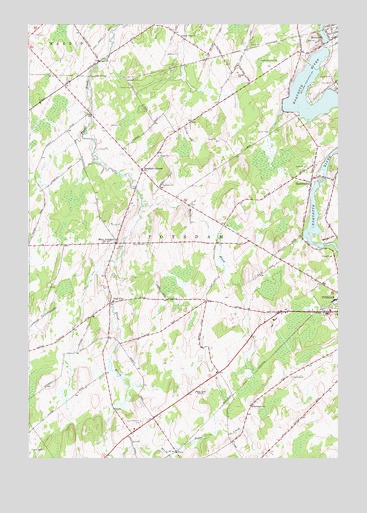
West Potsdam, NY USGS Topographic Map
Click on map above to begin viewing in our Map Viewer.

This topographic map contains these locations and features:
Feature Name Type Latitude Longitude GNIS ID View Map
Burnham CornersLocaleN44.7084°W75.0791°976062View Map
Dailey Ridge ChurchChurchN44.7467°W75.0635°976215View Map
EbenPopulated PlaceN44.6270°W75.0652°976279View Map
HewittvillePopulated PlaceN44.7045°W75.0108°976432View Map
Maple Street Trailer CourtPopulated PlaceN44.7449°W75.0016°2599026View Map
Norwood Hydro-Electric Generator StationBuildingN44.7431°W75.0042°2495743View Map
Norwood Village Water Pollution Control PlantLocaleN44.7482°W75.0089°2597216View Map
Riverside CemeteryCemeteryN44.7322°W75.0011°977243View Map
Sagamore FarmLocaleN44.6750°W75.0731°2559379View Map
Saint James CemeteryCemeteryN44.7472°W75.1246°976924View Map
Saint Lawrence NurseriesLocaleN44.6842°W75.0314°2559377View Map
Slab CityPopulated PlaceN44.6698°W75.0921°977007View Map
South Potsdam CemeteryCemeteryN44.6359°W75.0795°977037View Map
Stony BrookStreamN44.6998°W75.0796°977074View Map
Sugar CreekStreamN44.6264°W75.0691°977084View Map
Thompson SchoolSchoolN44.6401°W75.0346°977118View Map
Town of PotsdamCivilN44.6775°W75.0396°979390View Map
West PotsdamPopulated PlaceN44.6870°W75.0896°977257View Map
West Potsdam CemeteryCemeteryN44.6867°W75.0758°977258View Map
West Potsdam Volunteer Fire DepartmentBuildingN44.6871°W75.0906°2718455View Map
WPDM-AM (Potsdam)TowerN44.6439°W75.0585°977629View Map
WSNN-FM (Potsdam)TowerN44.6439°W75.0585°977777View Map
WTSC-FM (Potsdam)TowerN44.6626°W75.0016°977776View Map

Note: Coordinates in the location and feature list above are referenced to NAD83 datum.


Copyright (C) 2008-2024 Ryan Niemi / Sunset Dynamics ... All Rights Reserved