TopoQuest Logo
Do you find TopoQuest useful?
Help keep TopoQuest running and adding new maps/features by donating!
Bitcoin:  19c7KJd3qBynnjoSw5npx9KScwjBe4ifkT
Litecoin:  LXs6TkuXGGXo1vDsWCkWVdjQX94eUKd6ui
Home View Maps Find Maps Find Places Resources & Links


White River City, Colorado Topographic Map

USGS Map Title: White River City, CO
USGS Map MRC: 40108A2
DRG (GeoTIFF) Download: o40108a2.tif


Neighboring USGS Topographic Map Quads:


  Smizer Gulch, CO  
40108B3
 

  Indian Valley, CO  
40108B2
 

  White Rock, CO  
40108B1
 

  Barcus Creek SE, CO  
40108A3
 

  White River City, CO  
40108A2
 

  Buckskin Point, CO  
40108A1
 

  Square S Ranch, CO  
39108H3
 

  Greasewood Gulch, CO  
39108H2
 

  Segar Mountain, CO  
39108H1


Map MRC Location:

N41°
W109°
N41°
W108°
H8 H7 H6 H5 H4 H3 H2 H1
G8 G7 G6 G5 G4 G3 G2 G1
F8 F7 F6 F5 F4 F3 F2 F1
E8 E7 E6 E5 E4 E3 E2 E1
D8 D7 D6 D5 D4 D3 D2 D1
C8 C7 C6 C5 C4 C3 C2 C1
B8 B7 B6 B5 B4 B3 B2 B1
A8 A7 A6 A5 A4 A3 A2 A1
N40°
W109°
N40°
W108°

White River City, CO USGS 1:24K Topographic Map Preview:
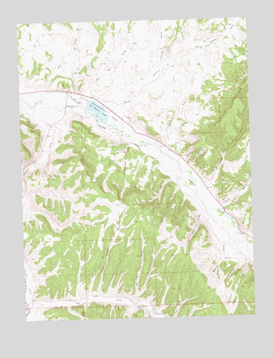
White River City, CO USGS Topographic Map
Click on map above to begin viewing in our Map Viewer.

This topographic map contains these locations and features:
Feature Name Type Latitude Longitude GNIS ID View Map
Beavers GulchValleyN40.0321°W108.1355°171727View Map
Beefsteak GulchValleyN40.0306°W108.1283°171738View Map
Blacks GulchValleyN40.0837°W108.1937°171717View Map
Box D GulchValleyN40.0059°W108.1906°171720View Map
Dry Fork Piceance CreekStreamN40.0075°W108.2459°171718View Map
Ernie Howard GulchValleyN40.0085°W108.2118°171728View Map
Johnnie Johnson DamDamN40.0883°W108.2140°199930View Map
Kellog GulchValleyN40.0720°W108.1723°171723View Map
Kissinger GulchValleyN40.0530°W108.1514°171725View Map
Little Hills Game Experiment StationLocaleN40.0055°W108.1909°169466View Map
Oil Well GulchValleyN40.0929°W108.2139°171631View Map
Piceance CreekStreamN40.0900°W108.2451°204652View Map
Rattlesnake GulchValleyN40.0748°W108.1914°171724View Map
Rio Blanco LakeReservoirN40.0876°W108.2079°171721View Map
Scenery GulchValleyN40.1137°W108.1507°171634View Map
Smith GulchValleyN40.0450°W108.1420°171654View Map
Tom Stith GulchValleyN40.0447°W108.1493°171726View Map
Tschuddi GulchValleyN40.1038°W108.1765°171637View Map
U.S.B.M. Number One ShaftMineN40.0433°W108.2462°1683137View Map
USBM Number One ShaftMineN40.0433°W108.2456°1794741View Map
White River CityPopulated PlaceN40.0908°W108.2243°171722View Map
Wray GulchValleyN40.0958°W108.2354°171630View Map

Note: Coordinates in the location and feature list above are referenced to NAD83 datum.


Copyright (C) 2008-2024 Ryan Niemi / Sunset Dynamics ... All Rights Reserved