TopoQuest Logo
Do you find TopoQuest useful?
Help keep TopoQuest running and adding new maps/features by donating!
Bitcoin:  19c7KJd3qBynnjoSw5npx9KScwjBe4ifkT
Litecoin:  LXs6TkuXGGXo1vDsWCkWVdjQX94eUKd6ui
Home View Maps Find Maps Find Places Resources & Links


Whitsett, Texas Topographic Map

USGS Map Title: Whitsett, TX
USGS Map MRC: 28098F3
DRG (GeoTIFF) Download: o28098f3.tif


Neighboring USGS Topographic Map Quads:


  Christine East, TX  
28098G4
 

  McCoy, TX  
28098G3
 

  Fashing, TX  
28098G2
 

  Caballos Creek, TX  
28098F4
 

  Whitsett, TX  
28098F3
 

  Peggy, TX  
28098F2
 

  Crowther, TX  
28098E4
 

  Willow Hollow Tank, TX  
28098E3
 

  Comanche Hills, TX  
28098E2


Map MRC Location:

N29°
W99°
N29°
W98°
H8 H7 H6 H5 H4 H3 H2 H1
G8 G7 G6 G5 G4 G3 G2 G1
F8 F7 F6 F5 F4 F3 F2 F1
E8 E7 E6 E5 E4 E3 E2 E1
D8 D7 D6 D5 D4 D3 D2 D1
C8 C7 C6 C5 C4 C3 C2 C1
B8 B7 B6 B5 B4 B3 B2 B1
A8 A7 A6 A5 A4 A3 A2 A1
N28°
W99°
N28°
W98°

Whitsett, TX USGS 1:24K Topographic Map Preview:
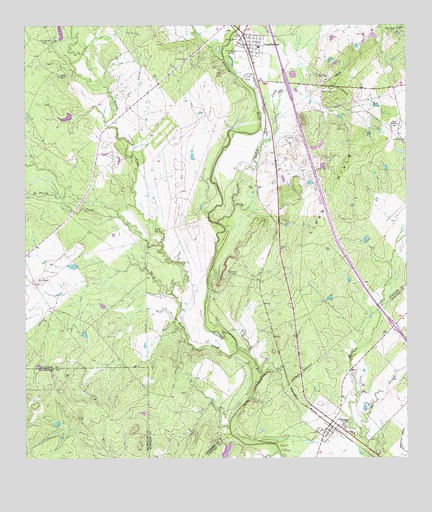
Whitsett, TX USGS Topographic Map
Click on map above to begin viewing in our Map Viewer.

This topographic map contains these locations and features:
Feature Name Type Latitude Longitude GNIS ID View Map
74 Ranch Dam Number 3DamN28.7453°W98.3636°1860468View Map
74 Ranch Dam Number 4DamN28.7236°W98.3603°1860470View Map
CampbelltonPopulated PlaceN28.7475°W98.3025°1372901View Map
Campbellton Post OfficePost OfficeN28.7438°W98.3018°2731251View Map
La Parita CreekStreamN28.6564°W98.3045°1360802View Map
Lake Number 3ReservoirN28.7490°W98.3637°1860469View Map
Lake Number 4ReservoirN28.7238°W98.3614°1860471View Map
Lipan CreekStreamN28.6933°W98.3114°1361254View Map
Lipan HillsSummitN28.6980°W98.2720°1361256View Map
Metate CreekStreamN28.6861°W98.3300°1374902View Map
Salt BranchStreamN28.6311°W98.2642°1367380View Map
Seventy-Four RanchLocaleN28.6769°W98.3706°1367995View Map
Tom RanchLocaleN28.7214°W98.2525°1370000View Map
Tom Ranch Lake Number 1ReservoirN28.7048°W98.2820°1864541View Map
Tom Ranch Lake Number 1 DamDamN28.7053°W98.2836°1864540View Map
Tom Ranch Lake Number 2ReservoirN28.7059°W98.2906°1864539View Map
Tom Ranch Lake Number 2 DamDamN28.7069°W98.2903°1864538View Map
WhitsettPopulated PlaceN28.6342°W98.2720°1371473View Map
Whitsett Post OfficePost OfficeN28.6320°W98.2776°2731196View Map

Note: Coordinates in the location and feature list above are referenced to NAD83 datum.


Copyright (C) 2008-2025 Ryan Niemi / Sunset Dynamics ... All Rights Reserved