TopoQuest Logo
Do you find TopoQuest useful?
Help keep TopoQuest running and adding new maps/features by donating!
Bitcoin:  19c7KJd3qBynnjoSw5npx9KScwjBe4ifkT
Litecoin:  LXs6TkuXGGXo1vDsWCkWVdjQX94eUKd6ui
Home View Maps Find Maps Find Places Resources & Links


Wickiup Dam, Oregon Topographic Map

USGS Map Title: Wickiup Dam, OR
USGS Map MRC: 43121F6
DRG (GeoTIFF) Download: o43121f6.tif


Neighboring USGS Topographic Map Quads:


  Crane Prairie Reservoir, OR  
43121G7
 

  Round Mountain, OR  
43121G6
 

  Pistol Butte, OR  
43121G5
 

  Davis Mountain, OR  
43121F7
 

  Wickiup Dam, OR  
43121F6
 

  La Pine, OR  
43121F5
 

  Hamner Butte, OR  
43121E7
 

  Cryder Butte, OR  
43121E6
 

  Masten Butte, OR  
43121E5


Map MRC Location:

N44°
W122°
N44°
W121°
H8 H7 H6 H5 H4 H3 H2 H1
G8 G7 G6 G5 G4 G3 G2 G1
F8 F7 F6 F5 F4 F3 F2 F1
E8 E7 E6 E5 E4 E3 E2 E1
D8 D7 D6 D5 D4 D3 D2 D1
C8 C7 C6 C5 C4 C3 C2 C1
B8 B7 B6 B5 B4 B3 B2 B1
A8 A7 A6 A5 A4 A3 A2 A1
N43°
W122°
N43°
W121°

Wickiup Dam, OR USGS 1:24K Topographic Map Preview:
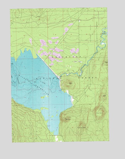
Wickiup Dam, OR USGS Topographic Map
Click on map above to begin viewing in our Map Viewer.

This topographic map contains these locations and features:
Feature Name Type Latitude Longitude GNIS ID View Map
Bull BendBendN43.7254°W121.6275°1138892View Map
Bull Bend Campground Boat LaunchLocaleN43.7258°W121.6279°2700230View Map
Bull Bend Recreation SiteLocaleN43.7254°W121.6281°1157062View Map
Davis CreekStreamN43.6818°W121.7442°1140663View Map
Dilman MeadowsSwampN43.6993°W121.6647°1141033View Map
Eaton ButteSummitN43.6450°W121.6805°1141656View Map
Gilchrist ButteSummitN43.6393°W121.6610°1142729View Map
Haner ButteSummitN43.6532°W121.6354°1143264View Map
Pringle Falls Experimental ForestForestN43.7385°W121.6431°1158430View Map
Pringle Falls Research Natural AreaParkN43.7096°W121.6270°1156415View Map
Round Swamp CampgroundLocaleN43.6401°W121.7067°1157064View Map
Stagnant LakeLakeN43.6776°W121.6372°1156846View Map
Tenino Boat LaunchLocaleN43.6879°W121.6731°1155895View Map
Tenino Boating SiteLocaleN43.6885°W121.6746°2700231View Map
Wampus CampgroundLocaleN43.7018°W121.6481°1157063View Map
Wickiup ButteSummitN43.6792°W121.6766°1152293View Map
Wickiup Butte Boat RampLocaleN43.6776°W121.6891°2700215View Map
Wickiup Butte Recreation SiteLocaleN43.6732°W121.6853°1155896View Map
Wickiup DamDamN43.6943°W121.7019°1152301View Map
Wickiup ReservoirReservoirN43.6789°W121.7324°1161711View Map
Wickiups (historical)LocaleN43.6832°W121.7178°1851753View Map
Wright ButteSummitN43.6671°W121.6331°1152659View Map

Note: Coordinates in the location and feature list above are referenced to NAD83 datum.


Copyright (C) 2008-2025 Ryan Niemi / Sunset Dynamics ... All Rights Reserved