TopoQuest Logo
Do you find TopoQuest useful?
Help keep TopoQuest running and adding new maps/features by donating!
Bitcoin:  19c7KJd3qBynnjoSw5npx9KScwjBe4ifkT
Litecoin:  LXs6TkuXGGXo1vDsWCkWVdjQX94eUKd6ui
Home View Maps Find Maps Find Places Resources & Links


Williams, Minnesota Topographic Map

USGS Map Title: Williams, MN
USGS Map MRC: 48094G8
DRG (GeoTIFF) Download: o48094g8.tif


Neighboring USGS Topographic Map Quads:


  Roosevelt NE, MN  
48095H1
 

  Williams NW, MN  
48094H8


  Roosevelt, MN  
48095G1
 

  Williams, MN  
48094G8
 

  Williams SE, MN  
48094G7
 

  Winter Road Lake, MN  
48095F1
 

  Graceton NW, MN  
48094F8
 

  Graceton, MN  
48094F7


Map MRC Location:

N49°
W95°
N49°
W94°
H8 H7 H6 H5 H4 H3 H2 H1
G8 G7 G6 G5 G4 G3 G2 G1
F8 F7 F6 F5 F4 F3 F2 F1
E8 E7 E6 E5 E4 E3 E2 E1
D8 D7 D6 D5 D4 D3 D2 D1
C8 C7 C6 C5 C4 C3 C2 C1
B8 B7 B6 B5 B4 B3 B2 B1
A8 A7 A6 A5 A4 A3 A2 A1
N48°
W95°
N48°
W94°

Williams, MN USGS 1:24K Topographic Map Preview:
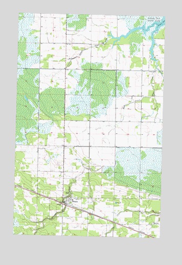
Williams, MN USGS Topographic Map
Click on map above to begin viewing in our Map Viewer.

This topographic map contains these locations and features:
Feature Name Type Latitude Longitude GNIS ID View Map
Assembly of God ChurchChurchN48.7694°W94.9536°2101845View Map
Bethel Lutheran ChurchChurchN48.7714°W94.9525°2101849View Map
Cedar Spur Post Office (historical)Post OfficeN48.7572°W94.9078°2103984View Map
Cedar Spur Station (historical)LocaleN48.7572°W94.9078°2103979View Map
City of WilliamsCivilN48.7680°W94.9533°2397316View Map
County Ditch Number OneCanalN48.7897°W94.9222°641554View Map
Hillside CemeteryCemeteryN48.8436°W94.8824°645013View Map
Lady Slipper Park Rest AreaLocaleN48.7683°W94.9592°2101852View Map
Lake of the Woods CountyCivilN48.7712°W94.9046°659483View Map
Pilgrim Congregational ChurchChurchN48.7675°W94.9500°2101848View Map
Pine Hill CemeteryCemeteryN48.7708°W94.9444°649461View Map
Saint Joseph Catholic ChurchChurchN48.7706°W94.9508°2101847View Map
South Branch Zippel CreekStreamN48.8689°W94.8811°652282View Map
Tourist ParkParkN48.7719°W94.9550°2101850View Map
Township of McDougaldCivilN48.7572°W94.8917°2397837View Map
Township of ZippelCivilN48.8416°W94.8971°2397902View Map
West Branch Zippel CreekStreamN48.8708°W94.8827°653943View Map
WilliamsLocaleN48.7675°W94.9547°2101839View Map
WilliamsPopulated PlaceN48.7683°W94.9552°654165View Map
Williams City Park CampgroundLocaleN48.7683°W94.9550°2101840View Map
Williams Community ChurchChurchN48.7697°W94.9556°2101846View Map
Williams CreekStreamN48.7878°W94.9361°654167View Map
Williams LibraryBuildingN48.7683°W94.9550°2101843View Map
Williams Post OfficePost OfficeN48.7683°W94.9550°2101844View Map
Williams Volunteer Fire DepartmentBuildingN48.7684°W94.9545°2101841View Map
Zippel Bay Resort CampgroundLocaleN48.8569°W94.8883°2100902View Map

Note: Coordinates in the location and feature list above are referenced to NAD83 datum.


Copyright (C) 2008-2025 Ryan Niemi / Sunset Dynamics ... All Rights Reserved