TopoQuest Logo
Do you find TopoQuest useful?
Help keep TopoQuest running and adding new maps/features by donating!
Bitcoin:  19c7KJd3qBynnjoSw5npx9KScwjBe4ifkT
Litecoin:  LXs6TkuXGGXo1vDsWCkWVdjQX94eUKd6ui
Home View Maps Find Maps Find Places Resources & Links


Willow Creek, Minnesota Topographic Map

USGS Map Title: Willow Creek, MN
USGS Map MRC: 43094H3
DRG (GeoTIFF) Download: o43094h3.tif


Neighboring USGS Topographic Map Quads:


  Madelia, MN  
44094A4
 

  Perth, MN  
44094A3
 

  Lake Crystal, MN  
44094A2
 

  Lewisville, MN  
43094H4
 

  Willow Creek, MN  
43094H3
 

  Amboy, MN  
43094H2
 

  Truman, MN  
43094G4
 

  Truman SE, MN  
43094G3
 

  Winnebago, MN  
43094G2


Map MRC Location:

N44°
W95°
N44°
W94°
H8 H7 H6 H5 H4 H3 H2 H1
G8 G7 G6 G5 G4 G3 G2 G1
F8 F7 F6 F5 F4 F3 F2 F1
E8 E7 E6 E5 E4 E3 E2 E1
D8 D7 D6 D5 D4 D3 D2 D1
C8 C7 C6 C5 C4 C3 C2 C1
B8 B7 B6 B5 B4 B3 B2 B1
A8 A7 A6 A5 A4 A3 A2 A1
N43°
W95°
N43°
W94°

Willow Creek, MN USGS 1:24K Topographic Map Preview:
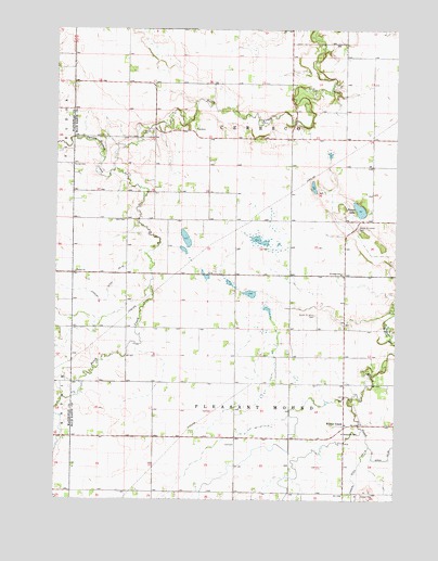
Willow Creek, MN USGS Topographic Map
Click on map above to begin viewing in our Map Viewer.

This topographic map contains these locations and features:
Feature Name Type Latitude Longitude GNIS ID View Map
County Ditch Number EightynineCanalN43.8858°W94.2533°642355View Map
Judicial Ditch Number FiftytwoCanalN43.9286°W94.3558°645942View Map
North Saint Johns CemeteryCemeteryN43.9472°W94.2647°648685View Map
Ohio CemeteryCemeteryN43.9491°W94.3497°648906View Map
Porter LakeLakeN43.9522°W94.2635°649677View Map
Saint John's Lutheran ChurchChurchN43.9344°W94.2694°2051529View Map
Saint Johns SchoolSchoolN43.9350°W94.2702°650732View Map
School Number 167SchoolN43.8930°W94.2689°651414View Map
South Saint Johns CemeteryCemeteryN43.9241°W94.2794°652338View Map
Spring Branch CreekStreamN43.9630°W94.3539°652422View Map
Township of CerescoCivilN43.9782°W94.3090°663775View Map
Township of Pleasant MoundCivilN43.8914°W94.3090°665322View Map
Trinity CemeteryCemeteryN43.9636°W94.3697°653283View Map
Trinity ChurchChurchN43.9352°W94.3680°653303View Map
Willow CreekPopulated PlaceN43.8947°W94.2686°655013View Map
Willowcreek Post Office (historical)Post OfficeN43.8947°W94.2686°2051650View Map
Zarn AirportAirportN43.9065°W94.2748°2676817View Map

Note: Coordinates in the location and feature list above are referenced to NAD83 datum.


Copyright (C) 2008-2025 Ryan Niemi / Sunset Dynamics ... All Rights Reserved