TopoQuest Logo
Do you find TopoQuest useful?
Help keep TopoQuest running and adding new maps/features by donating!
Bitcoin:  19c7KJd3qBynnjoSw5npx9KScwjBe4ifkT
Litecoin:  LXs6TkuXGGXo1vDsWCkWVdjQX94eUKd6ui
Home View Maps Find Maps Find Places Resources & Links


Willows, California Topographic Map

USGS Map Title: Willows, CA
USGS Map MRC: 39122E2
DRG (GeoTIFF) Download: o39122e2.tif


Neighboring USGS Topographic Map Quads:


  Fruto NE, CA  
39122F3
 

  Orland, CA  
39122F2
 

  Hamilton City, CA  
39122F1
 

  Stone Valley, CA  
39122E3
 

  Willows, CA  
39122E2
 

  Glenn, CA  
39122E1
 

  Logan Ridge, CA  
39122D3
 

  Logandale, CA  
39122D2
 

  Princeton, CA  
39122D1


Map MRC Location:

N40°
W123°
N40°
W122°
H8 H7 H6 H5 H4 H3 H2 H1
G8 G7 G6 G5 G4 G3 G2 G1
F8 F7 F6 F5 F4 F3 F2 F1
E8 E7 E6 E5 E4 E3 E2 E1
D8 D7 D6 D5 D4 D3 D2 D1
C8 C7 C6 C5 C4 C3 C2 C1
B8 B7 B6 B5 B4 B3 B2 B1
A8 A7 A6 A5 A4 A3 A2 A1
N39°
W123°
N39°
W122°

Willows, CA USGS 1:24K Topographic Map Preview:
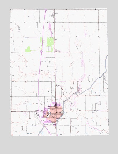
Willows, CA USGS Topographic Map
Click on map above to begin viewing in our Map Viewer.

This topographic map contains these locations and features:
Feature Name Type Latitude Longitude GNIS ID View Map
Ajax FieldParkN39.5143°W122.1919°218037View Map
ArtoisPopulated PlaceN39.6196°W122.1939°1657951View Map
Artois Fire Protection DistrictBuildingN39.6172°W122.1950°2622001View Map
Artois Post OfficePost OfficeN39.6211°W122.1948°1702515View Map
Bibleway Association ChurchChurchN39.5221°W122.1966°1702516View Map
BluegumPopulated PlaceN39.5835°W122.1933°1702517View Map
California Highway Patrol WillowsBuildingN39.5263°W122.2116°2751103View Map
Central ParkParkN39.5171°W122.2080°1702524View Map
City of WillowsCivilN39.5147°W122.1991°2412272View Map
Civic Memorial BuildingBuildingN39.5210°W122.2003°1702526View Map
Enloe Ambulance Service WillowsBuildingN39.5220°W122.2080°2662297View Map
Faith Baptist ChurchChurchN39.5257°W122.1986°1702535View Map
First Baptist ChurchChurchN39.5215°W122.1991°1702539View Map
First Church of Christ ScientistChurchN39.5177°W122.1964°1702540View Map
First Lutheran ChurchChurchN39.5257°W122.1978°1702542View Map
First Southern Baptist ChurchChurchN39.5213°W122.1905°1702543View Map
First United Methodist ChurchChurchN39.5229°W122.1966°1702544View Map
French CreekStreamN39.5624°W122.2342°223902View Map
Glenn County CourthouseBuildingN39.5202°W122.2003°1702547View Map
Glenn County Golf and Country ClubLocaleN39.5835°W122.2217°1702548View Map
Glenn County JailBuildingN39.5196°W122.2008°1702549View Map
Glenn County Sheriff's OfficeBuildingN39.5194°W122.2005°2751017View Map
Glenn Medical CenterHospitalN39.5212°W122.2082°1702587View Map
Holy Trinity Episcopal ChurchChurchN39.5204°W122.1886°1702554View Map
Hydrick PitMineN39.6000°W122.1533°2678017View Map
Jensen ParkParkN39.5121°W122.2005°1702556View Map
Kanawha SchoolSchoolN39.5243°W122.2497°226422View Map
KIQS-AM (Willows)TowerN39.5288°W122.1703°1662782View Map
KIQS-FM (Willows)TowerN39.5288°W122.1703°1663143View Map
Lyman (historical)Populated PlaceN39.5688°W122.1936°1702560View Map
Memorial ParkParkN39.5210°W122.2014°1702565View Map
Mendocino National Forest Fire Service United States Department of AgricultureBuildingN39.5302°W122.2129°2622286View Map
Murdock Elementary SchoolSchoolN39.5273°W122.2018°1702567View Map
Noltas Airport (historical)AirportN39.5817°W122.1977°1654121View Map
Pentecostal Church of GodChurchN39.5157°W122.1950°1702576View Map
Primera Mission BautistaChurchN39.5202°W122.1905°1702577View Map
Saint Monicas Roman Catholic ChurchChurchN39.5204°W122.1978°1702581View Map
Saint Pauls Lutheran ChurchChurchN39.6188°W122.1953°1702582View Map
Sheep Corral CreekStreamN39.5774°W122.2353°234686View Map
South Fork Willow CreekStreamN39.5196°W122.1622°235068View Map
Sycamore ParkParkN39.5190°W122.2033°1702586View Map
Walker CreekStreamN39.5371°W122.1764°237172View Map
Willow Glenn Mobile Home ParkPopulated PlaceN39.5219°W122.2328°2515996View Map
WillowsPopulated PlaceN39.5243°W122.1936°1660184View Map
WILLOWS CATHOLIOC CEMETERYCemeteryN39.5246°W122.1844°1702523View Map
Willows Christian ChurchChurchN39.5190°W122.1978°1702589View Map
Willows City HallBuildingN39.5213°W122.1950°1702590View Map
Willows City Police DepartmentBuildingN39.5219°W122.2001°2751038View Map
Willows Community High SchoolSchoolN39.5183°W122.2040°1702591View Map
Willows Fire DepartmentBuildingN39.5158°W122.1956°2621854View Map
Willows High SchoolSchoolN39.5224°W122.2018°1702592View Map
Willows Intermediate SchoolSchoolN39.5147°W122.2072°1702593View Map
Willows Post OfficePost OfficeN39.5208°W122.1972°1702594View Map
Willows Public LibraryBuildingN39.5218°W122.2003°1702595View Map
Willows Rural Fire Protection DistrictBuildingN39.5158°W122.1956°2622068View Map
Willows Union Grammar School (historical)SchoolN39.5199°W122.2039°1702596View Map
Willows Wastewater Treatment PlantLocaleN39.5006°W122.1897°2356913View Map
Willows Westside Mall Shopping CenterLocaleN39.5218°W122.1947°1702597View Map
Willows-Glenn County AirportAirportN39.5206°W122.2176°1654122View Map
Wilson CreekStreamN39.5196°W122.1622°237966View Map

Note: Coordinates in the location and feature list above are referenced to NAD83 datum.


Copyright (C) 2008-2024 Ryan Niemi / Sunset Dynamics ... All Rights Reserved