TopoQuest Logo
Do you find TopoQuest useful?
Help keep TopoQuest running and adding new maps/features by donating!
Bitcoin:  19c7KJd3qBynnjoSw5npx9KScwjBe4ifkT
Litecoin:  LXs6TkuXGGXo1vDsWCkWVdjQX94eUKd6ui
Home View Maps Find Maps Find Places Resources & Links


Botsford, Connecticut Topographic Map

USGS Map Title: Botsford, CT
USGS Map MRC: 41073C3
DRG (GeoTIFF) Download: o41073c3.tif


Neighboring USGS Topographic Map Quads:


  Danbury, CT  
41073D4
 

  Newtown, CT  
41073D3
 

  Southbury, CT  
41073D2
 

  Bethel, CT  
41073C4
 

  Botsford, CT  
41073C3
 

  Long Hill, CT  
41073C2
 

  Norwalk North, CT  
41073B4
 

  Westport, CT  
41073B3
 

  Bridgeport, CT  
41073B2


Map MRC Location:

N42°
W74°
N42°
W73°
H8 H7 H6 H5 H4 H3 H2 H1
G8 G7 G6 G5 G4 G3 G2 G1
F8 F7 F6 F5 F4 F3 F2 F1
E8 E7 E6 E5 E4 E3 E2 E1
D8 D7 D6 D5 D4 D3 D2 D1
C8 C7 C6 C5 C4 C3 C2 C1
B8 B7 B6 B5 B4 B3 B2 B1
A8 A7 A6 A5 A4 A3 A2 A1
N41°
W74°
N41°
W73°

Botsford, CT USGS 1:24K Topographic Map Preview:
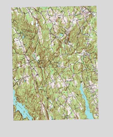
Botsford, CT USGS Topographic Map
Click on map above to begin viewing in our Map Viewer.

This topographic map contains these locations and features:
Feature Name Type Latitude Longitude GNIS ID View Map
Ballwall BrookStreamN41.2565°W73.3223°205237View Map
Bart Center Shopping CenterLocaleN41.3326°W73.2643°1941670View Map
Big LakeLakeN41.3093°W73.3069°205492View Map
BotsfordPopulated PlaceN41.3665°W73.2571°205651View Map
Botsford Fire RescueBuildingN41.3631°W73.2675°2420382View Map
Botsford Post OfficePost OfficeN41.3625°W73.2661°1941743View Map
Botsford Station (historical)LocaleN41.3668°W73.2657°1941744View Map
Christ ChurchChurchN41.2751°W73.2935°206271View Map
Christ ChurchChurchN41.2870°W73.2596°206272View Map
Christ ChurchChurchN41.3137°W73.3510°1941850View Map
Christ Church CemeteryCemeteryN41.3135°W73.3506°1941851View Map
Chub BrookStreamN41.2712°W73.2665°206274View Map
Chucks Corner Shopping CenterLocaleN41.3045°W73.2543°1941860View Map
Codfish HillLocaleN41.3690°W73.3587°206351View Map
Cogers PondLakeN41.3654°W73.2807°206354View Map
Connecticut Golf ClubLocaleN41.2668°W73.3343°1941925View Map
Coolfish HillSummitN41.3668°W73.3657°1941927View Map
Covenant Church of EastonChurchN41.2718°W73.2976°1941945View Map
EastonPopulated PlaceN41.2529°W73.2973°206880View Map
Easton Baptist ChurchChurchN41.2740°W73.2965°1942020View Map
Easton ReservoirReservoirN41.2648°W73.2671°206881View Map
Easton Town Police DepartmentBuildingN41.2545°W73.2989°2754769View Map
Eden HillSummitN41.3329°W73.3143°206894View Map
Falls PondLakeN41.3151°W73.3377°207021View Map
Five PointsPopulated PlaceN41.3223°W73.3565°207092View Map
Flirt HillSummitN41.2540°W73.3276°207115View Map
Flying Ridge AirstripAirportN41.3676°W73.2908°213090View Map
Gilbert BrookStreamN41.2626°W73.3546°207295View Map
Greisers Store (historical)LocaleN41.2523°W73.2982°1942181View Map
Guskie PondLakeN41.3357°W73.2916°207576View Map
HattertownPopulated PlaceN41.3412°W73.3090°207721View Map
Hattertown PondLakeN41.3438°W73.3024°207722View Map
Hedmons PondLakeN41.3082°W73.3322°207768View Map
Hirams HillSummitN41.2976°W73.2623°207855View Map
HopewellPopulated PlaceN41.3473°W73.3365°212482View Map
Huntington PondLakeN41.3421°W73.3582°208037View Map
Huntington Pond DikeDamN41.3429°W73.3579°1770613View Map
Huntington State ParkParkN41.3512°W73.3560°208038View Map
HuntingtownPopulated PlaceN41.3582°W73.2854°212484View Map
Huntingtown CemeteryCemeteryN41.3502°W73.2931°208039View Map
Joel Barlow Regional High SchoolSchoolN41.2998°W73.3387°205261View Map
Kachele PondLakeN41.2547°W73.2528°208216View Map
Lakewood CampLocaleN41.3168°W73.2696°208368View Map
Lewis BrookStreamN41.3437°W73.2921°208448View Map
Lewis PondLakeN41.3462°W73.3175°208452View Map
Lily PondLakeN41.3475°W73.3604°208468View Map
Little RiverStreamN41.2848°W73.3743°208526View Map
Livermore Pond (historical)LakeN41.2836°W73.3363°208534View Map
Lyons SwampSwampN41.3048°W73.3181°208655View Map
Meekers HillSummitN41.3098°W73.3423°208816View Map
Middle Gate Elementary SchoolSchoolN41.3665°W73.2740°208862View Map
Mirror LakeLakeN41.2935°W73.3574°208962View Map
Monroe Corporate ParkLocaleN41.3484°W73.2582°1942504View Map
Morgan CemeteryCemeteryN41.3673°W73.3305°209038View Map
Mother Superior LakeLakeN41.3132°W73.3064°209068View Map
Myers PondLakeN41.3694°W73.2999°209161View Map
North PondLakeN41.3497°W73.3648°209370View Map
Old Indian CemeteryCemeteryN41.2811°W73.3431°1942635View Map
PalestinePopulated PlaceN41.3657°W73.3198°212538View Map
Patterson BrookStreamN41.2898°W73.2896°209645View Map
Pleasant ValleyValleyN41.3229°W73.3423°209848View Map
Popps Mountain DikeDamN41.2534°W73.3462°1770234View Map
Redding Fire Department and Emergency Medical Services Company Station 1BuildingN41.3099°W73.3478°2420318View Map
Redding Paramedic AllianceBuildingN41.3097°W73.3478°2660861View Map
Redding RidgePopulated PlaceN41.3140°W73.3504°210148View Map
Redding RidgeSummitN41.3170°W73.3535°1942717View Map
Redding Ridge CemeteryCemeteryN41.3088°W73.3471°210149View Map
Redding Ridge Post OfficePost OfficeN41.3011°W73.3462°1942718View Map
Rock RaymondPopulated PlaceN41.2909°W73.2743°210252View Map
Rock RaymondSummitN41.2909°W73.2743°1942761View Map
Rockland PondsLakeN41.3637°W73.3053°210261View Map
Round HillSummitN41.2520°W73.2829°210313View Map
Saint Patricks ChurchChurchN41.3082°W73.3476°210561View Map
Samuel Staples Elementary SchoolSchoolN41.2523°W73.2954°211144View Map
Sand Hill Plaza Shopping CenterLocaleN41.3695°W73.2715°1943268View Map
SanfordtownPopulated PlaceN41.2948°W73.3623°212563View Map
Saugatuck ReservoirReservoirN41.2673°W73.3667°210654View Map
Senoir ParkParkN41.2534°W73.2971°1942914View Map
South PondLakeN41.3336°W73.3546°211000View Map
StepneyPopulated PlaceN41.3040°W73.2543°211158View Map
Stepney Baptist ChurchChurchN41.3209°W73.2646°1943005View Map
Stepney CemeteryCemeteryN41.3224°W73.2630°211157View Map
Stepney Elementary SchoolSchoolN41.3179°W73.2529°211159View Map
Stepney High SchoolSchoolN41.3176°W73.2529°1943277View Map
Stepney Volunteer Fire Company Station 1BuildingN41.3009°W73.2512°2420420View Map
Stepney Volunteer Fire Company Station 2BuildingN41.3461°W73.2601°2420312View Map
Sunset HillSummitN41.3376°W73.3615°211294View Map
Tashua Burial GroundCemeteryN41.2869°W73.2597°211362View Map
Tashua Knolls Country ClubLocaleN41.2851°W73.2526°1943040View Map
Tatetuck BrookStreamN41.2834°W73.2790°211365View Map
Town of EastonCivilN41.2649°W73.3001°213427View Map
Twin BridgesLocaleN41.2743°W73.3248°211627View Map
Union CemeteryCemeteryN41.2729°W73.2968°211658View Map
Upper StepneyPopulated PlaceN41.3226°W73.2651°211706View Map
WMNR-FM (Monroe)TowerN41.3190°W73.2532°213277View Map

Note: Coordinates in the location and feature list above are referenced to NAD83 datum.


Copyright (C) 2008-2024 Ryan Niemi / Sunset Dynamics ... All Rights Reserved