TopoQuest Logo
Do you find TopoQuest useful?
Help keep TopoQuest running and adding new maps/features by donating!
Bitcoin:  19c7KJd3qBynnjoSw5npx9KScwjBe4ifkT
Litecoin:  LXs6TkuXGGXo1vDsWCkWVdjQX94eUKd6ui
Home View Maps Find Maps Find Places Resources & Links


Winton, Washington Topographic Map

USGS Map Title: Winton, WA
USGS Map MRC: 47120F6
DRG (GeoTIFF) Download: o47120f6.tif


Neighboring USGS Topographic Map Quads:


  Lake Wenatchee, WA  
47120G7
 

  Plain, WA  
47120G6
 

  Sugarloaf Peak, WA  
47120G5
 

  Big Jim Mountain, WA  
47120F7
 

  Winton, WA  
47120F6
 

  Van Creek, WA  
47120F5
 

  Cashmere Mountain, WA  
47120E7
 

  Leavenworth, WA  
47120E6
 

  Peshastin, WA  
47120E5


Map MRC Location:

N48°
W121°
N48°
W120°
H8 H7 H6 H5 H4 H3 H2 H1
G8 G7 G6 G5 G4 G3 G2 G1
F8 F7 F6 F5 F4 F3 F2 F1
E8 E7 E6 E5 E4 E3 E2 E1
D8 D7 D6 D5 D4 D3 D2 D1
C8 C7 C6 C5 C4 C3 C2 C1
B8 B7 B6 B5 B4 B3 B2 B1
A8 A7 A6 A5 A4 A3 A2 A1
N47°
W121°
N47°
W120°

Winton, WA USGS 1:24K Topographic Map Preview:
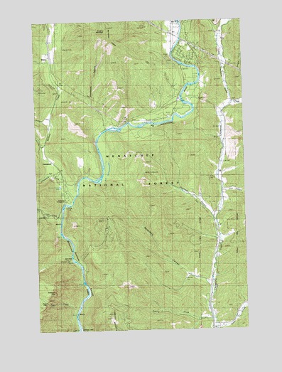
Winton, WA USGS Topographic Map
Click on map above to begin viewing in our Map Viewer.

This topographic map contains these locations and features:
Feature Name Type Latitude Longitude GNIS ID View Map
Cabin CreekStreamN47.6251°W120.7273°1517193View Map
Chelan County Fire District 4BuildingN47.7342°W120.6613°2643810View Map
ChiwaukumPopulated PlaceN47.6904°W120.7359°1517730View Map
Chiwaukum CreekStreamN47.6787°W120.7281°1517731View Map
ChumstickPopulated PlaceN47.6882°W120.6393°1517763View Map
Clark CanyonValleyN47.6798°W120.6393°1517803View Map
Deadhorse CanyonValleyN47.7104°W120.7095°1518539View Map
Drury FallsFallsN47.6368°W120.7466°1518932View Map
Fall CreekStreamN47.6332°W120.7273°1519446View Map
Freund CreekStreamN47.6290°W120.6459°1519808View Map
Hatchery CreekStreamN47.6707°W120.7356°1520599View Map
Josephine CragPillarN47.6410°W120.7415°1521473View Map
Little Chumstick CreekStreamN47.7165°W120.6340°1522186View Map
Natapoc MountainSummitN47.7473°W120.7065°1523586View Map
Natapoc RidgeRidgeN47.7471°W120.7065°1531482View Map
Skinney CreekStreamN47.6865°W120.7345°1525864View Map
Spromberg CanyonValleyN47.6443°W120.6506°1526428View Map
Sunitsch CanyonValleyN47.6707°W120.6448°1526745View Map
Swift Water Picnic AreaLocaleN47.6543°W120.7290°1526866View Map
Thomson CreekStreamN47.7107°W120.7420°1527116View Map
Tumwater CampgroundLocaleN47.6771°W120.7331°1527450View Map
WintonPopulated PlaceN47.7354°W120.7412°1528263View Map
Winton Elementary SchoolSchoolN47.7423°W120.7437°1531203View Map

Note: Coordinates in the location and feature list above are referenced to NAD83 datum.


Copyright (C) 2008-2024 Ryan Niemi / Sunset Dynamics ... All Rights Reserved