TopoQuest Logo
Do you find TopoQuest useful?
Help keep TopoQuest running and adding new maps/features by donating!
Bitcoin:  19c7KJd3qBynnjoSw5npx9KScwjBe4ifkT
Litecoin:  LXs6TkuXGGXo1vDsWCkWVdjQX94eUKd6ui
Home View Maps Find Maps Find Places Resources & Links


Boulder Canyon, Nevada Topographic Map

USGS Map Title: Boulder Canyon, NV
USGS Map MRC: 36114B5
DRG (GeoTIFF) Download: o36114b5.tif


Neighboring USGS Topographic Map Quads:


  Muddy Peak, NV  
36114C6
 

  Bitter Spring, NV  
36114C5
 

  Echo Bay, NV  
36114C4
 

  Callville Bay, NV  
36114B6
 

  Boulder Canyon, NV  
36114B5
 

  Middle Point, NV  
36114B4
 

  Hoover Dam, NV  
36114A6
 

  Petroglyph Wash, AZ  
36114A5
 

  Bonelli Bay, AZ  
36114A4


Map MRC Location:

N37°
W115°
N37°
W114°
H8 H7 H6 H5 H4 H3 H2 H1
G8 G7 G6 G5 G4 G3 G2 G1
F8 F7 F6 F5 F4 F3 F2 F1
E8 E7 E6 E5 E4 E3 E2 E1
D8 D7 D6 D5 D4 D3 D2 D1
C8 C7 C6 C5 C4 C3 C2 C1
B8 B7 B6 B5 B4 B3 B2 B1
A8 A7 A6 A5 A4 A3 A2 A1
N36°
W115°
N36°
W114°

Boulder Canyon, NV USGS 1:24K Topographic Map Preview:
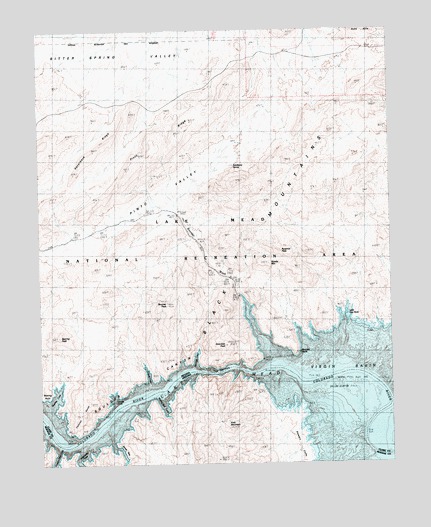
Boulder Canyon, NV USGS Topographic Map
Click on map above to begin viewing in our Map Viewer.

This topographic map contains these locations and features:
Feature Name Type Latitude Longitude GNIS ID View Map
Arch MountainSummitN36.1358°W114.5608°758View Map
Bearing CoveBayN36.1455°W114.6197°849296View Map
Bearing PeakSummitN36.1616°W114.6222°838664View Map
Bearing PointCapeN36.1455°W114.6236°849375View Map
Bitter Spring ValleyBasinN36.2405°W114.6000°863745View Map
Boulder CanyonValleyN36.1369°W114.6230°1863View Map
Boulder Canyon Dam SiteLocaleN36.1514°W114.5511°863352View Map
Boulder PeakSummitN36.1722°W114.5819°839007View Map
Boulder PointCapeN36.1594°W114.5380°849301View Map
Boulder Rapids (historical)RapidsN36.1522°W114.5397°863353View Map
Boulder WashStreamN36.1730°W114.5550°839012View Map
Boulder Wash CoveBayN36.1650°W114.5497°863738View Map
Canyon PointRidgeN36.1394°W114.6103°863750View Map
Canyon Point CoveBayN36.1275°W114.6203°43034View Map
Coyote CoveBayN36.1511°W114.5875°849298View Map
East End LightLocaleN36.1550°W114.5519°863659View Map
Flamingo CoveBayN36.1555°W114.5705°849299View Map
Gordys CoveBayN36.1441°W114.5997°849297View Map
Guardian PeakSummitN36.1594°W114.5603°840839View Map
Gypsum BedsBarN36.1614°W114.5161°849517View Map
James BayBayN36.1289°W114.5972°6349View Map
Little Gyp BedsBarN36.1678°W114.5166°849302View Map
Pinto RidgeRidgeN36.2200°W114.5814°842853View Map
Pinto ValleyBasinN36.2033°W114.5822°847457View Map
Pinto Valley WildernessReserveN36.1917°W114.5846°2575145View Map
Pyramid PeakSummitN36.1869°W114.5416°843011View Map
Razorback RidgeRidgeN36.2186°W114.6036°843121View Map
Saddle MountainSummitN36.1819°W114.5453°845644View Map
Sandstone SpringSpringN36.2110°W114.5563°843501View Map
Sidewinder CoveBayN36.1280°W114.6114°43033View Map
Stewart CliffsCliffN36.1300°W114.5339°43118View Map
The NarrowsChannelN36.1522°W114.5600°849300View Map
Wishing Well CoveBayN36.1416°W114.5819°13946View Map

Note: Coordinates in the location and feature list above are referenced to NAD83 datum.


Copyright (C) 2008-2024 Ryan Niemi / Sunset Dynamics ... All Rights Reserved