TopoQuest Logo
Do you find TopoQuest useful?
Help keep TopoQuest running and adding new maps/features by donating!
Bitcoin:  19c7KJd3qBynnjoSw5npx9KScwjBe4ifkT
Litecoin:  LXs6TkuXGGXo1vDsWCkWVdjQX94eUKd6ui
Home View Maps Find Maps Find Places Resources & Links


Boulder West, Montana Topographic Map

USGS Map Title: Boulder West, MT
USGS Map MRC: 46112B2
DRG (GeoTIFF) Download: o46112b2.tif


Neighboring USGS Topographic Map Quads:


  Basin, MT  
46112C3
 

  Mount Thompson, MT  
46112C2
 

  Wickes, MT  
46112C1
 

  Bison Canyon, MT  
46112B3
 

  Boulder West, MT  
46112B2
 

  Boulder East, MT  
46112B1
 

  Whitetail Peak, MT  
46112A3
 

  Ratio Mountain, MT  
46112A2
 

  Wilson Park, MT  
46112A1


Map MRC Location:

N47°
W113°
N47°
W112°
H8 H7 H6 H5 H4 H3 H2 H1
G8 G7 G6 G5 G4 G3 G2 G1
F8 F7 F6 F5 F4 F3 F2 F1
E8 E7 E6 E5 E4 E3 E2 E1
D8 D7 D6 D5 D4 D3 D2 D1
C8 C7 C6 C5 C4 C3 C2 C1
B8 B7 B6 B5 B4 B3 B2 B1
A8 A7 A6 A5 A4 A3 A2 A1
N46°
W113°
N46°
W112°

Boulder West, MT USGS 1:24K Topographic Map Preview:
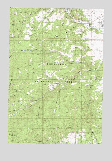
Boulder West, MT USGS Topographic Map
Click on map above to begin viewing in our Map Viewer.

This topographic map contains these locations and features:
Feature Name Type Latitude Longitude GNIS ID View Map
Berkin GulchValleyN46.1849°W112.1703°779717View Map
Big Major MineMineN46.1313°W112.2358°779841View Map
Boulder View MineMineN46.2455°W112.2445°803543View Map
Boulder Work CenterLocaleN46.2463°W112.1403°780286View Map
Buck Horn MineMineN46.2230°W112.2461°803542View Map
Buffalo CreekStreamN46.1497°W112.2461°780539View Map
Crowley DamDamN46.1933°W112.1506°798895View Map
Crowley MineMineN46.1930°W112.1528°781937View Map
Doe RidgeRidgeN46.2238°W112.1833°794104View Map
Elder CreekStreamN46.1802°W112.1839°783031View Map
Elder Creek ParkFlatN46.1802°W112.1853°783032View Map
Elder Creek Picnic AreaLocaleN46.1802°W112.1853°1802546View Map
First Assembly of God ChurchChurchN46.2344°W112.1267°1762547View Map
Free Enterprise Health Mine and CampgroundLocaleN46.2369°W112.1531°1762591View Map
Galena ParkFlatN46.2299°W112.2258°794108View Map
Gatlin GulchValleyN46.1783°W112.1822°783869View Map
Hyndman (historical)LocaleN46.2380°W112.1467°1762513View Map
Jerry Smith CreekStreamN46.1580°W112.2261°785469View Map
Kilborn GulchValleyN46.2447°W112.1739°785727View Map
May Day MineMineN46.2255°W112.1672°786956View Map
May Day MineMineN46.2269°W112.1656°803485View Map
Menzemer (historical)LocaleN46.2472°W112.1397°1762663View Map
Montana Developmental CenterHospitalN46.2360°W112.1253°1762539View Map
Moose CreekStreamN46.1546°W112.2375°787637View Map
Mountain Valley Trailer CourtPopulated PlaceN46.2347°W112.1261°1762597View Map
North Fork Little Boulder RiverStreamN46.1938°W112.1417°788199View Map
Pole GulchValleyN46.1855°W112.1625°789063View Map
Poore GulchValleyN46.2341°W112.1456°789087View Map
Porcupine GulchValleyN46.2083°W112.2470°789105View Map
Pulpit RockSummitN46.2366°W112.1419°794105View Map
Saul's Claim MineMineN46.2255°W112.2350°803490View Map
Sauls ClaimCivilN46.2260°W112.2356°794349View Map
Springtime MineMineN46.1949°W112.1564°791329View Map
Springtime MineMineN46.1952°W112.1558°803486View Map
SW SW Section 8 MineMineN46.1938°W112.1381°803487View Map
Tesky CreekStreamN46.1647°W112.2139°792005View Map
The Church of Jesus Christ of Latter Day SaintsChurchN46.2347°W112.1267°1762546View Map
Victory MineMineN46.2469°W112.2389°803348View Map
Water GulchValleyN46.2366°W112.2331°792870View Map
Watson GulchValleyN46.2363°W112.1622°792885View Map
West CreekStreamN46.1941°W112.1347°792962View Map
Wilson CreekStreamN46.1644°W112.2139°793382View Map

Note: Coordinates in the location and feature list above are referenced to NAD83 datum.


Copyright (C) 2008-2025 Ryan Niemi / Sunset Dynamics ... All Rights Reserved