TopoQuest Logo
Do you find TopoQuest useful?
Help keep TopoQuest running and adding new maps/features by donating!
Bitcoin:  19c7KJd3qBynnjoSw5npx9KScwjBe4ifkT
Litecoin:  LXs6TkuXGGXo1vDsWCkWVdjQX94eUKd6ui
Home View Maps Find Maps Find Places Resources & Links


Wright Patman Lake, Texas Topographic Map

USGS Map Title: Wright Patman Lake, TX
USGS Map MRC: 33094C2
DRG (GeoTIFF) Download: o33094c2.tif


Neighboring USGS Topographic Map Quads:


  Hooks, TX  
33094D3
 

  Leary, TX  
33094D2
 

  Texarkana, TX  
33094D1
 

  Maud, TX  
33094C3
 

  Wright Patman Lake, TX  
33094C2
 

  Domino, TX  
33094C1
 

  Douglassville, TX  
33094B3
 

  Atlanta North, TX  
33094B2
 

  Bloomburg, TX  
33094B1


Map MRC Location:

N34°
W95°
N34°
W94°
H8 H7 H6 H5 H4 H3 H2 H1
G8 G7 G6 G5 G4 G3 G2 G1
F8 F7 F6 F5 F4 F3 F2 F1
E8 E7 E6 E5 E4 E3 E2 E1
D8 D7 D6 D5 D4 D3 D2 D1
C8 C7 C6 C5 C4 C3 C2 C1
B8 B7 B6 B5 B4 B3 B2 B1
A8 A7 A6 A5 A4 A3 A2 A1
N33°
W95°
N33°
W94°

Wright Patman Lake, TX USGS 1:24K Topographic Map Preview:
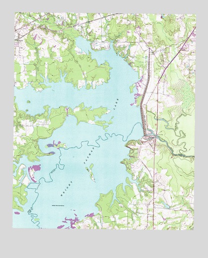
Wright Patman Lake, TX USGS Topographic Map
Click on map above to begin viewing in our Map Viewer.

This topographic map contains these locations and features:
Feature Name Type Latitude Longitude GNIS ID View Map
Akin CreekStreamN33.3076°W94.1391°1372252View Map
Bells IslandIslandN33.2829°W94.1963°1372491View Map
Big Creek ParkParkN33.3160°W94.2449°2028787View Map
Boone CreekStreamN33.3621°W94.2102°1852152View Map
Cass County Fire District 2 Domino StationBuildingN33.2623°W94.1465°2655245View Map
Caver LakeReservoirN33.2642°W94.1442°1854996View Map
Caver Lake DamDamN33.2635°W94.1419°1854995View Map
Clear Spring ParkParkN33.3568°W94.1896°2028616View Map
Day CreekStreamN33.3621°W94.2102°1829121View Map
East Fork Elliott CreekStreamN33.3687°W94.2235°1373538View Map
Elliott CreekStreamN33.2937°W94.1327°1373626View Map
Fleming CreekStreamN33.3598°W94.2007°1829122View Map
Hollaway CemeteryCemeteryN33.3673°W94.2327°1374106View Map
Kelly Creek ParkParkN33.2937°W94.2494°2029035View Map
McCartney BridgeBridgeN33.3046°W94.1516°1374835View Map
Opossum Trot ChurchChurchN33.3523°W94.1532°1375303View Map
R C Miller Memorial LibraryBuildingN33.3046°W94.1719°2014796View Map
Redwater Volunteer Fire DepartmentBuildingN33.3616°W94.2495°2655637View Map
Rochelle CreekStreamN33.3335°W94.2241°1375542View Map
Rocky Point ParkParkN33.2993°W94.1655°2029465View Map
Rocky Point Park TrailTrailN33.2893°W94.1738°2033208View Map
Texarkana DamDamN33.3140°W94.1610°1376397View Map
Wright Patman DamDamN33.3074°W94.1598°1854278View Map

Note: Coordinates in the location and feature list above are referenced to NAD83 datum.


Copyright (C) 2008-2024 Ryan Niemi / Sunset Dynamics ... All Rights Reserved