TopoQuest Logo
Do you find TopoQuest useful?
Help keep TopoQuest running and adding new maps/features by donating!
Bitcoin:  19c7KJd3qBynnjoSw5npx9KScwjBe4ifkT
Litecoin:  LXs6TkuXGGXo1vDsWCkWVdjQX94eUKd6ui
Home View Maps Find Maps Find Places Resources & Links


Yachats, Oregon Topographic Map

USGS Map Title: Yachats, OR
USGS Map MRC: 44124C1
DRG (GeoTIFF) Download: o44124c1.tif


Neighboring USGS Topographic Map Quads:


  Waldport, OR  
44124D1
 

  Tidewater, OR  
44123D8


  Yachats, OR  
44124C1
 

  Cannibal Mountain, OR  
44123C8


  Heceta Head, OR  
44124B1
 

  Cummins Peak, OR  
44123B8


Map MRC Location:

N45°
W125°
N45°
W124°
H8 H7 H6 H5 H4 H3 H2 H1
G8 G7 G6 G5 G4 G3 G2 G1
F8 F7 F6 F5 F4 F3 F2 F1
E8 E7 E6 E5 E4 E3 E2 E1
D8 D7 D6 D5 D4 D3 D2 D1
C8 C7 C6 C5 C4 C3 C2 C1
B8 B7 B6 B5 B4 B3 B2 B1
A8 A7 A6 A5 A4 A3 A2 A1
N44°
W125°
N44°
W124°

Yachats, OR USGS 1:24K Topographic Map Preview:
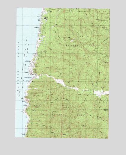
Yachats, OR USGS Topographic Map
Click on map above to begin viewing in our Map Viewer.

This topographic map contains these locations and features:
Feature Name Type Latitude Longitude GNIS ID View Map
Agate PointCapeN44.3040°W124.1090°1154744View Map
Agency CreekStreamN44.3185°W124.1096°1137029View Map
Amanda CreekStreamN44.2914°W124.1123°2652253View Map
Amanda's StatueParkN44.2898°W124.0969°2680537View Map
Amanda's TrailTrailN44.2899°W124.0966°2680536View Map
Angell Job Corps CenterLocaleN44.3651°W124.0887°1155939View Map
Barkley CreekStreamN44.3090°W124.0943°1154750View Map
Beamer CreekStreamN44.2951°W124.0234°1137624View Map
Bend CreekStreamN44.2918°W124.0065°1137915View Map
Big CreekStreamN44.3707°W124.0887°1138001View Map
Big Creek Log PondReservoirN44.3629°W124.0863°1154759View Map
Blodgett PeakSummitN44.3462°W124.0590°1138268View Map
Blodgett Work CenterLocaleN44.3571°W124.0776°1155941View Map
Camp AngellLocaleN44.3651°W124.0873°1135338View Map
Camp One (historical)LocaleN44.3460°W124.0915°1135337View Map
Cape CreekStreamN44.2823°W124.1104°1139344View Map
Cape PerpetuaCapeN44.2871°W124.1151°1139355View Map
Cape Perpetua Recreation SiteLocaleN44.2810°W124.1051°1162397View Map
Cape Perpetua Special Interest AreaParkN44.2793°W124.1126°1158159View Map
Cape Perpetua Visitor CenterBuildingN44.2810°W124.1088°2554218View Map
Cape RidgeRidgeN44.2735°W124.0348°1139356View Map
Captain Cook PointCapeN44.2757°W124.1157°1139364View Map
Carson CemeteryCemeteryN44.2942°W124.0092°1139398View Map
Carson CreekStreamN44.2951°W124.0101°1139399View Map
Cedar CreekStreamN44.3026°W124.0640°1154812View Map
City of YachatsCivilN44.3127°W124.1023°2412313View Map
Clear CreekStreamN44.2915°W124.0123°1159288View Map
Cleft of the Rock Cape Perpetua LighthouseBuildingN44.2904°W124.1108°2661382View Map
Cooks ChasmBayN44.2776°W124.1143°1158177View Map
Crotchline SaddleGapN44.3632°W124.0157°1140484View Map
Cummins CreekStreamN44.2660°W124.1093°1140549View Map
Cummins Creek WildernessReserveN44.2506°W124.0459°1155945View Map
Dawson CreekStreamN44.2915°W124.0137°1159287View Map
Desolation SaddleGapN44.3557°W124.0059°1140926View Map
Devils ChurnBayN44.2843°W124.1123°1140944View Map
Dicks ForkStreamN44.3660°W124.0862°1141019View Map
Dicks RidgeRidgeN44.3551°W124.0512°1141022View Map
Fourmile CampParkN44.2832°W124.0554°1154745View Map
Gender CreekStreamN44.2993°W124.1110°1154813View Map
Green MountainSummitN44.3165°W124.0510°1143044View Map
Gregory CreekStreamN44.3046°W124.1082°1154814View Map
Gwynn CreekStreamN44.2704°W124.1110°1143172View Map
Kerby MountainSummitN44.3290°W124.0332°1144568View Map
Kerby RidgeRidgeN44.3229°W124.0346°1154743View Map
Little Beamer CreekStreamN44.2957°W124.0246°1135336View Map
Little Beaver CreekStreamN44.2951°W124.0243°1155937View Map
Little Cummins CreekStreamN44.2654°W124.1065°1145142View Map
Long CreekStreamN44.3040°W124.0668°1154811View Map
Marks CreekStreamN44.2973°W124.0473°1123769View Map
Mitchell CreekStreamN44.3254°W124.1046°1154753View Map
Nancy CreekStreamN44.2568°W124.1110°1154752View Map
Neptune State ParkParkN44.2612°W124.1082°1158390View Map
North Cape CreekStreamN44.2910°W124.1118°1146888View Map
Placer LakeLakeN44.3713°W124.0828°1158917View Map
Reedy CreekStreamN44.2990°W124.0598°1148363View Map
Restless Waters TrailheadLocaleN44.2838°W124.1102°1952944View Map
Reynolds CreekStreamN44.3740°W124.0915°1148394View Map
ReynoldsvilleLocaleN44.3248°W124.0998°1154754View Map
Salmon CreekStreamN44.3107°W124.0904°1148969View Map
San MarinePopulated PlaceN44.3537°W124.0940°1149021View Map
San Marine State ParkParkN44.3471°W124.0965°1154756View Map
Smelt Sands State Recreation SiteParkN44.3226°W124.1054°1154758View Map
South Beamer CreekStreamN44.2968°W124.0262°1159286View Map
South Fork Big CreekStreamN44.3607°W124.0885°1149933View Map
South Lincoln Ambulance ServiceBuildingN44.3111°W124.1047°2553799View Map
Spring CreekStreamN44.3040°W124.0721°1154810View Map
Starr CreekStreamN44.3318°W124.1018°1150351View Map
Strawberry HillSummitN44.2539°W124.1118°1154757View Map
Strawberry Hill Picnic AreaLocaleN44.2540°W124.1123°1135335View Map
Tillicum BeachPopulated PlaceN44.3629°W124.0929°1154755View Map
Tillicum Beach Recreation SiteLocaleN44.3654°W124.0926°1159354View Map
Vingie CreekStreamN44.3404°W124.0993°1151777View Map
Wenner CreekStreamN44.2935°W124.0004°1152549View Map
Wolf CreekStreamN44.3065°W124.0710°1155938View Map
YachatsPopulated PlaceN44.3112°W124.1048°1152681View Map
Yachats City HallBuildingN44.3128°W124.1050°2661442View Map
Yachats Memorial ParkCemeteryN44.3199°W124.0983°1158560View Map
Yachats MountainSummitN44.3462°W124.0135°1158561View Map
Yachats Municipal CourtBuildingN44.3128°W124.1050°2661439View Map
Yachats Ocean Road State Natural SiteParkN44.3062°W124.1051°1158562View Map
Yachats Post OfficePost OfficeN44.3105°W124.1042°1166218View Map
Yachats Public WorksBuildingN44.3128°W124.1051°2661530View Map
Yachats Purchase UnitForestN44.3498°W124.0346°1167058View Map
Yachats RiverStreamN44.3090°W124.1082°1152683View Map
Yachats Rural Fire Protection District South StationBuildingN44.3112°W124.1045°2576494View Map
Yachats Sewage Treatment PlantLocaleN44.3142°W124.1070°2660680View Map
Yachats State Recreation AreaParkN44.3112°W124.1087°1158563View Map
Yachats Water Treatment PlantLocaleN44.3112°W124.0900°2660771View Map

Note: Coordinates in the location and feature list above are referenced to NAD83 datum.


Copyright (C) 2008-2024 Ryan Niemi / Sunset Dynamics ... All Rights Reserved