TopoQuest Logo
Do you find TopoQuest useful?
Help keep TopoQuest running and adding new maps/features by donating!
Bitcoin:  19c7KJd3qBynnjoSw5npx9KScwjBe4ifkT
Litecoin:  LXs6TkuXGGXo1vDsWCkWVdjQX94eUKd6ui
Home View Maps Find Maps Find Places Resources & Links


Youngs Peak, California Topographic Map

USGS Map Title: Youngs Peak, CA
USGS Map MRC: 41123B3
DRG (GeoTIFF) Download: o41123b3.tif


Neighboring USGS Topographic Map Quads:


  Orleans Mountain, CA  
41123C4
 

  Forks of Salmon, CA  
41123C3
 

  Sawyers Bar, CA  
41123C2
 

  Salmon Mountain, CA  
41123B4
 

  Youngs Peak, CA  
41123B3
 

  Cecilville, CA  
41123B2
 

  Trinity Mountain, CA  
41123A4
 

  Dees Peak, CA  
41123A3
 

  Cecil Lake, CA  
41123A2


Map MRC Location:

N42°
W124°
N42°
W123°
H8 H7 H6 H5 H4 H3 H2 H1
G8 G7 G6 G5 G4 G3 G2 G1
F8 F7 F6 F5 F4 F3 F2 F1
E8 E7 E6 E5 E4 E3 E2 E1
D8 D7 D6 D5 D4 D3 D2 D1
C8 C7 C6 C5 C4 C3 C2 C1
B8 B7 B6 B5 B4 B3 B2 B1
A8 A7 A6 A5 A4 A3 A2 A1
N41°
W124°
N41°
W123°

Youngs Peak, CA USGS 1:24K Topographic Map Preview:
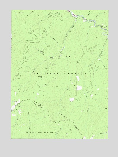
Youngs Peak, CA USGS Topographic Map
Click on map above to begin viewing in our Map Viewer.

This topographic map contains these locations and features:
Feature Name Type Latitude Longitude GNIS ID View Map
Ball MineMineN41.1793°W123.2575°233458View Map
Barton CabinLocaleN41.2107°W123.3112°233461View Map
Bell MineMineN41.1724°W123.2781°233486View Map
Blackberry CreekStreamN41.2124°W123.3095°233513View Map
Bowerman PeakSummitN41.1849°W123.3362°233539View Map
Brook MineMineN41.1460°W123.3331°233548View Map
Cold SpringSpringN41.2248°W123.3396°233697View Map
East Fork Knownothing CreekStreamN41.2146°W123.3070°233820View Map
Gilta (historical)Populated PlaceN41.1954°W123.3250°1682768View Map
Gilta MineMineN41.1962°W123.3217°233924View Map
Granite GulchValleyN41.1940°W123.3034°233944View Map
HansenMineN41.2071°W123.3117°233982View Map
Henry Bell GulchValleyN41.2432°W123.2803°234005View Map
High PointCapeN41.1860°W123.3684°234010View Map
Horn Creek GapGapN41.2471°W123.3648°234030View Map
Horse MountainSummitN41.1540°W123.2520°1660770View Map
Hotelling CampgroundLocaleN41.2396°W123.2753°234042View Map
Hotelling GulchValleyN41.2382°W123.2770°234043View Map
Hotelling RidgeRidgeN41.1862°W123.2920°234044View Map
Jack Harveys CrossingCrossingN41.1665°W123.3712°277238View Map
Johnson CreekStreamN41.2040°W123.2639°234090View Map
Knownothing CreekStreamN41.2435°W123.2914°234113View Map
Knownothing LakeLakeN41.1607°W123.3741°234114View Map
Knownothing MineMineN41.2035°W123.3217°234115View Map
Missouri BarBarN41.2485°W123.3006°234313View Map
Negro CreekStreamN41.2393°W123.2687°234357View Map
Negro Hill MineMineN41.2418°W123.2792°277242View Map
O'Farrill GulchValleyN41.2318°W123.2567°234395View Map
Poverty GulchValleyN41.2029°W123.3289°234510View Map
Red Hill MineMineN41.2454°W123.2934°277241View Map
Salmon Summit MineMineN41.1560°W123.3662°234609View Map
Salmon Summit MineMineN41.1562°W123.3667°277239View Map
Shingle FlatFlatN41.2471°W123.3162°234691View Map
Sign CreekStreamN41.1979°W123.2712°234697View Map
Slate GapGapN41.1604°W123.3628°234711View Map
Stanslaw MineMineN41.2490°W123.2984°277240View Map
Tryer MineMineN41.2135°W123.3062°277237View Map
West Fork Knownothing CreekStreamN41.2146°W123.3070°237476View Map
Wolverine MineMineN41.2087°W123.3376°238104View Map
Youngs PeakSummitN41.1560°W123.3414°238286View Map

Note: Coordinates in the location and feature list above are referenced to NAD83 datum.


Copyright (C) 2008-2024 Ryan Niemi / Sunset Dynamics ... All Rights Reserved