TopoQuest Logo
Do you find TopoQuest useful?
Help keep TopoQuest running and adding new maps/features by donating!
Bitcoin:  19c7KJd3qBynnjoSw5npx9KScwjBe4ifkT
Litecoin:  LXs6TkuXGGXo1vDsWCkWVdjQX94eUKd6ui
Home View Maps Find Maps Find Places Resources & Links


Yountville, California Topographic Map

USGS Map Title: Yountville, CA
USGS Map MRC: 38122D3
DRG (GeoTIFF) Download: o38122d3.tif


Neighboring USGS Topographic Map Quads:


  Saint Helena, CA  
38122E4
 

  Chiles Valley, CA  
38122E3
 

  Lake Berryessa, CA  
38122E2
 

  Rutherford, CA  
38122D4
 

  Yountville, CA  
38122D3
 

  Capell Valley, CA  
38122D2
 

  Sonoma, CA  
38122C4
 

  Napa, CA  
38122C3
 

  Mount George, CA  
38122C2


Map MRC Location:

N39°
W123°
N39°
W122°
H8 H7 H6 H5 H4 H3 H2 H1
G8 G7 G6 G5 G4 G3 G2 G1
F8 F7 F6 F5 F4 F3 F2 F1
E8 E7 E6 E5 E4 E3 E2 E1
D8 D7 D6 D5 D4 D3 D2 D1
C8 C7 C6 C5 C4 C3 C2 C1
B8 B7 B6 B5 B4 B3 B2 B1
A8 A7 A6 A5 A4 A3 A2 A1
N38°
W123°
N38°
W122°

Yountville, CA USGS 1:24K Topographic Map Preview:
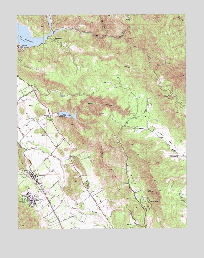
Yountville, CA USGS Topographic Map
Click on map above to begin viewing in our Map Viewer.

This topographic map contains these locations and features:
Feature Name Type Latitude Longitude GNIS ID View Map
Alatera VineyardsLocaleN38.3796°W122.3516°1800347View Map
Anderson VineyardsLocaleN38.4241°W122.3414°1800348View Map
Atlas PeakSummitN38.4507°W122.2628°233443View Map
Calafia WineryLocaleN38.3966°W122.3219°1800351View Map
Castle PeakSummitN38.3969°W122.2778°233644View Map
Caymus (historical)Populated PlaceN38.4055°W122.3636°1800354View Map
Chappellet VineyardsLocaleN38.4891°W122.3264°1800356View Map
Chateau Chevre WineryLocaleN38.3763°W122.3489°1800357View Map
Chiles CreekStreamN38.4871°W122.3555°233665View Map
Chimney Rock Golf Course (historical)LocaleN38.3860°W122.3122°1800358View Map
Circle S 2417 DamDamN38.4199°W122.2694°1664452View Map
Circle S RanchLocaleN38.4174°W122.2625°233680View Map
City of YountvilleCivilN38.3955°W122.3669°2412323View Map
Clear CreekStreamN38.4877°W122.3103°233687View Map
Conn CreekStreamN38.4194°W122.3539°233707View Map
Conn DamDamN38.4810°W122.3733°233708View Map
Domaine Chandon WineryLocaleN38.4055°W122.3728°1800361View Map
Fir CanyonValleyN38.4860°W122.2983°233878View Map
Girard WineryLocaleN38.4582°W122.3683°1800366View Map
HaystackSummitN38.4419°W122.3169°233994View Map
Hopper CreekStreamN38.3771°W122.3160°2513448View Map
Hopper Creek WineryLocaleN38.3821°W122.3386°1800367View Map
KVYN-FM (St. Helena)TowerN38.4260°W122.3269°1663102View Map
Lake HennesseyReservoirN38.4900°W122.3721°234004View Map
Lakespring WineryLocaleN38.3852°W122.3536°1800370View Map
Napa County Fire Department Station 12 YountvilleBuildingN38.3950°W122.3574°2623824View Map
Napa County Fire Department Station 13 Soda CanyonBuildingN38.4100°W122.2952°2624028View Map
Napa County Sheriff's Office YountvilleBuildingN38.4015°W122.3599°2755764View Map
Napa Soda SpringsPopulated PlaceN38.3907°W122.2794°1659763View Map
Napa State FarmLocaleN38.4388°W122.3641°234351View Map
Nelson M Holderman Memorial HospitalHospitalN38.3900°W122.3633°1951388View Map
Pine Ridge WineryLocaleN38.4007°W122.3303°1800375View Map
Pritchard HillLocaleN38.4857°W122.3486°234512View Map
Rector CanyonValleyN38.4416°W122.3494°234546View Map
Rector CreekStreamN38.4285°W122.3711°234547View Map
Rector Creek 1-0 1 DamDamN38.4421°W122.3455°1663225View Map
Rector ReservoirReservoirN38.4417°W122.3388°234548View Map
Sage CanyonValleyN38.4896°W122.3497°234601View Map
Sage CreekStreamN38.4896°W122.3497°234602View Map
Shafer VineyardsLocaleN38.4169°W122.3239°1800385View Map
Silver Oak CellarsLocaleN38.4402°W122.3733°1800387View Map
Silverado VineyardLocaleN38.4146°W122.3386°1800388View Map
Stags LeapCliffN38.4199°W122.3136°235349View Map
Stags Leap Wine CellarsLocaleN38.3977°W122.3136°1800389View Map
Veterans Home Post OfficePost OfficeN38.3913°W122.3665°1951387View Map
Veterans Memorial Grove CemeteryCemeteryN38.3915°W122.3711°2773308View Map
Villa Mount Eden WineryLocaleN38.4519°W122.3733°1800393View Map
YountvillePopulated PlaceN38.4016°W122.3608°1652660View Map
Yountville Branch Napa City-County LibraryBuildingN38.4035°W122.3616°1800396View Map
Yountville Community ChurchChurchN38.4050°W122.3630°2651121View Map
Yountville Elementary SchoolSchoolN38.4039°W122.3615°1800397View Map
Yountville Post OfficePost OfficeN38.4014°W122.3602°1800398View Map
Yountville Town HallBuildingN38.4035°W122.3616°1800399View Map

Note: Coordinates in the location and feature list above are referenced to NAD83 datum.


Copyright (C) 2008-2024 Ryan Niemi / Sunset Dynamics ... All Rights Reserved