TopoQuest Logo
Do you find TopoQuest useful?
Help keep TopoQuest running and adding new maps/features by donating!
Bitcoin:  19c7KJd3qBynnjoSw5npx9KScwjBe4ifkT
Litecoin:  LXs6TkuXGGXo1vDsWCkWVdjQX94eUKd6ui
Home View Maps Find Maps Find Places Resources & Links


Alexander Mountain, Montana Topographic Map

USGS Map Title: Alexander Mountain, MT
USGS Map MRC: 48115D3
DRG (GeoTIFF) Download: o48115d3.tif


Neighboring USGS Topographic Map Quads:


  Banfield Mountain, MT  
48115E4
 

  Ural Creek, MT  
48115E3
 

  Volcour Gulch, MT  
48115E2
 

  Vermiculite Mountain, MT  
48115D4
 

  Alexander Mountain, MT  
48115D3
 

  Cripple Horse Mountain, MT  
48115D2
 

  Swede Mountain, MT  
48115C4
 

  Tony Peak, MT  
48115C3
 

  Richards Mountain, MT  
48115C2


Map MRC Location:

N49°
W116°
N49°
W115°
H8 H7 H6 H5 H4 H3 H2 H1
G8 G7 G6 G5 G4 G3 G2 G1
F8 F7 F6 F5 F4 F3 F2 F1
E8 E7 E6 E5 E4 E3 E2 E1
D8 D7 D6 D5 D4 D3 D2 D1
C8 C7 C6 C5 C4 C3 C2 C1
B8 B7 B6 B5 B4 B3 B2 B1
A8 A7 A6 A5 A4 A3 A2 A1
N48°
W116°
N48°
W115°

Alexander Mountain, MT USGS 1:24K Topographic Map Preview:
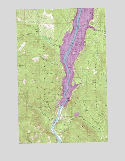
Alexander Mountain, MT USGS Topographic Map
Click on map above to begin viewing in our Map Viewer.

This topographic map contains these locations and features:
Feature Name Type Latitude Longitude GNIS ID View Map
Alexander CreekStreamN48.3916°W115.3285°778939View Map
Alexander MountainSummitN48.4405°W115.3538°778940View Map
Canyon CreekStreamN48.4191°W115.3091°780899View Map
Cripple Horse CreekStreamN48.4758°W115.2924°781899View Map
Cripple Horse MarinaLocaleN48.4861°W115.2704°1782410View Map
David Thompson BridgeBridgeN48.4066°W115.3173°1782349View Map
Dunn CreekStreamN48.3822°W115.3227°782709View Map
Dunn Creek (historical)LocaleN48.3916°W115.3121°1782217View Map
Dunn Creek FlatsFlatN48.3902°W115.2999°1782337View Map
Fleetwood PointSummitN48.4475°W115.3735°802099View Map
Gopher HillSummitN48.4486°W115.2785°802111View Map
Hook-U-Up RV ParkLocaleN48.4166°W115.2927°1782372View Map
Jackson CreekStreamN48.4547°W115.3099°785389View Map
Koocanusa ResortLocaleN48.4844°W115.2677°1782371View Map
Kootenai NarrowsGapN48.4150°W115.3068°785842View Map
Libby DamDamN48.4104°W115.3150°795726View Map
Libby Dam Visitor CenterLocaleN48.4083°W115.3093°1782338View Map
Little Jackson CreekStreamN48.4508°W115.3102°786308View Map
McGillivray CampgroundLocaleN48.4888°W115.2996°1782411View Map
North Fork Jackson CreekStreamN48.4758°W115.3452°788190View Map
Peace CreekStreamN48.4308°W115.3091°788720View Map
Souse CreekStreamN48.4191°W115.3110°790870View Map
Souse Gulch Picnic AreaLocaleN48.4133°W115.3177°1782408View Map
Souse RidgeRidgeN48.4100°W115.3338°790871View Map
South Fork Jackson CreekStreamN48.4755°W115.3452°790989View Map
Warland CreekStreamN48.4830°W115.2818°799132View Map
Yarnell (historical)LocaleN48.4708°W115.2924°802242View Map
Yarnell IslandIslandN48.4583°W115.2960°1782409View Map
Yarnell Island CampgroundLocaleN48.4588°W115.2963°794399View Map

Note: Coordinates in the location and feature list above are referenced to NAD83 datum.


Copyright (C) 2008-2025 Ryan Niemi / Sunset Dynamics ... All Rights Reserved