TopoQuest Logo
Do you find TopoQuest useful?
Help keep TopoQuest running and adding new maps/features by donating!
Bitcoin:  19c7KJd3qBynnjoSw5npx9KScwjBe4ifkT
Litecoin:  LXs6TkuXGGXo1vDsWCkWVdjQX94eUKd6ui
Home View Maps Find Maps Find Places Resources & Links


Bowler, Montana Topographic Map

USGS Map Title: Bowler, MT
USGS Map MRC: 45108B6
DRG (GeoTIFF) Download: o45108b6.tif


Neighboring USGS Topographic Map Quads:


  Bluewater, MT  
45108C7
 

  Section House Draw, MT  
45108C6
 

  Castle Rocks, MT  
45108C5
 

  Wade, MT  
45108B7
 

  Bowler, MT  
45108B6
 

  Indian Spring, MT  
45108B5
 

  Hunters Creek, MT  
45108A7
 

  Warren, MT  
45108A6
 

  Bear Canyon, MT  
45108A5


Map MRC Location:

N46°
W109°
N46°
W108°
H8 H7 H6 H5 H4 H3 H2 H1
G8 G7 G6 G5 G4 G3 G2 G1
F8 F7 F6 F5 F4 F3 F2 F1
E8 E7 E6 E5 E4 E3 E2 E1
D8 D7 D6 D5 D4 D3 D2 D1
C8 C7 C6 C5 C4 C3 C2 C1
B8 B7 B6 B5 B4 B3 B2 B1
A8 A7 A6 A5 A4 A3 A2 A1
N45°
W109°
N45°
W108°

Bowler, MT USGS 1:24K Topographic Map Preview:
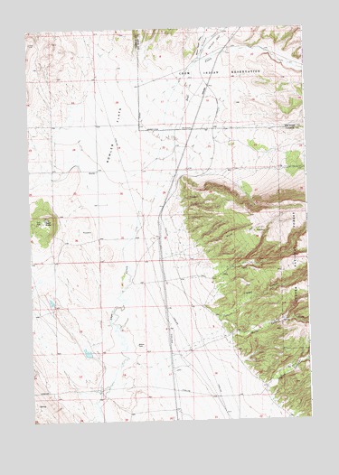
Bowler, MT USGS Topographic Map
Click on map above to begin viewing in our Map Viewer.

This topographic map contains these locations and features:
Feature Name Type Latitude Longitude GNIS ID View Map
07S24E25AAAA01 WellWellN45.2047°W108.7196°808417View Map
07S25E23CABB01 WellWellN45.2113°W108.6315°808436View Map
07S25E28AAA_01 WellWellN45.2044°W108.6604°808416View Map
08S25E04CCC_01 WellWellN45.1616°W108.6782°808240View Map
08S25E06DCDC01 WellWellN45.1538°W108.7060°808204View Map
Black ButteSummitN45.1897°W108.7432°779970View Map
BowlerPopulated PlaceN45.2049°W108.7190°780311View Map
Bowler (historical)LocaleN45.2049°W108.7190°1726674View Map
Bowler CemeteryCemeteryN45.1491°W108.7026°780312View Map
Bowler FlatsFlatN45.2161°W108.7087°780313View Map
Bowler Post Office (historical)Post OfficeN45.2049°W108.7190°1726673View Map
Bowler School (historical)SchoolN45.1944°W108.7201°1726813View Map
East Carbon DivisionCivilN45.1757°W108.6542°1940581View Map
Marlew Number 2 DamDamN45.1466°W108.7240°797472View Map
Miller TrailTrailN45.1902°W108.6393°787435View Map
Section House DrawValleyN45.2394°W108.6743°790186View Map
Summit CreekStreamN45.2377°W108.6760°791663View Map
Timber CanyonValleyN45.1572°W108.6657°792179View Map
Water CanyonValleyN45.1519°W108.6599°792866View Map

Note: Coordinates in the location and feature list above are referenced to NAD83 datum.


Copyright (C) 2008-2025 Ryan Niemi / Sunset Dynamics ... All Rights Reserved