TopoQuest Logo
Do you find TopoQuest useful?
Help keep TopoQuest running and adding new maps/features by donating!
Bitcoin:  19c7KJd3qBynnjoSw5npx9KScwjBe4ifkT
Litecoin:  LXs6TkuXGGXo1vDsWCkWVdjQX94eUKd6ui
Home View Maps Find Maps Find Places Resources & Links


Brady North, Texas Topographic Map

USGS Map Title: Brady North, TX
USGS Map MRC: 31099B3
DRG (GeoTIFF) Download: o31099b3.tif


Neighboring USGS Topographic Map Quads:


  Lohn, TX  
31099C4
 

  Bluff Creek, TX  
31099C3
 

  Placid, TX  
31099C2
 

  West Sweden, TX  
31099B4
 

  Brady North, TX  
31099B3
 

  Rochelle, TX  
31099B2
 

  Brady SW, TX  
31099A4
 

  Brady South, TX  
31099A3
 

  Voca, TX  
31099A2


Map MRC Location:

N32°
W100°
N32°
W99°
H8 H7 H6 H5 H4 H3 H2 H1
G8 G7 G6 G5 G4 G3 G2 G1
F8 F7 F6 F5 F4 F3 F2 F1
E8 E7 E6 E5 E4 E3 E2 E1
D8 D7 D6 D5 D4 D3 D2 D1
C8 C7 C6 C5 C4 C3 C2 C1
B8 B7 B6 B5 B4 B3 B2 B1
A8 A7 A6 A5 A4 A3 A2 A1
N31°
W100°
N31°
W99°

Brady North, TX USGS 1:24K Topographic Map Preview:
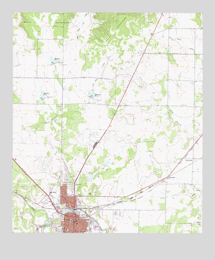
Brady North, TX USGS Topographic Map
Click on map above to begin viewing in our Map Viewer.

This topographic map contains these locations and features:
Feature Name Type Latitude Longitude GNIS ID View Map
Bible Baptist ChurchChurchN31.1310°W99.3331°2022434View Map
BradyPopulated PlaceN31.1352°W99.3351°1352814View Map
Brady - McCulloch County Emergency Medical ServiceBuildingN31.1337°W99.3329°2656125View Map
Brady City HallBuildingN31.1358°W99.3337°2753367View Map
Brady Fire DepartmentBuildingN31.1350°W99.3365°2551957View Map
Brady High SchoolSchoolN31.1277°W99.3423°2007673View Map
Brady Junior High SchoolSchoolN31.1316°W99.3345°2007674View Map
Brady Police DepartmentBuildingN31.1332°W99.3330°2750569View Map
Brady Post OfficePost OfficeN31.1332°W99.3338°2732311View Map
Bulldog StadiumParkN31.1277°W99.3423°2027948View Map
Central Baptist ChurchChurchN31.1304°W99.3409°2022435View Map
Curtis FieldAirportN31.1764°W99.3198°1386279View Map
Curtis Field (historical)MilitaryN31.1786°W99.3231°2105528View Map
East SwedenPopulated PlaceN31.1674°W99.2562°1379693View Map
First United ChurchChurchN31.1524°W99.3339°1357346View Map
First United Methodist Church of BradyChurchN31.1327°W99.3339°2022377View Map
Gene Naumann Dam 1DamN31.1552°W99.3237°1857525View Map
Gene Naumann Dam 2DamN31.1635°W99.3137°1857523View Map
Gene Naumann Lake 1ReservoirN31.1570°W99.3231°1857526View Map
Gene Naumann Lake 2ReservoirN31.1648°W99.3128°1857524View Map
Heart of Texas Historical MuseumBuildingN31.1396°W99.3364°2014484View Map
Jubilee RacetrackLocaleN31.1263°W99.3573°1384744View Map
KNEL-AM (Brady)TowerN31.1302°W99.3228°1385512View Map
Lake Brady ParkParkN31.1338°W99.3742°2029026View Map
Leatherwood Memorial Chapel ChurchChurchN31.1277°W99.3331°2022378View Map
Little Onion CreekStreamN31.1841°W99.2503°1350806View Map
Live Oak CemeteryCemeteryN31.1421°W99.3323°1361525View Map
Live Oak CreekStreamN31.1374°W99.3392°1361532View Map
McCulloch CountyCivilN31.1989°W99.3475°1383945View Map
McCulloch County Constable's Office Precinct 1BuildingN31.1358°W99.3371°2750623View Map
McCulloch County Law Enforcement CenterBuildingN31.1358°W99.3371°2738865View Map
McCulloch County Sheriff's OfficeBuildingN31.1358°W99.3371°2750260View Map
North Ward Primary SchoolSchoolN31.1446°W99.3381°2007676View Map
Old McCulloch County JailBuildingN31.1354°W99.3359°2031772View Map
Parker DamDamN31.1635°W99.3520°1857527View Map
Parker LakeReservoirN31.1639°W99.3535°1857528View Map
Paul JunctionPopulated PlaceN31.1568°W99.2728°1380331View Map
Post Oak CreekStreamN31.1302°W99.3539°1365653View Map
Reservoir Number FortyfiveReservoirN31.2216°W99.3476°1366356View Map
Reservoir Number FortyfourReservoirN31.2013°W99.3551°1366355View Map
Reservoir Number FortysixReservoirN31.2024°W99.3242°1366357View Map
Rest Haven CemeteryCemeteryN31.1429°W99.3542°1366366View Map
Richards ParkParkN31.1327°W99.3503°1366424View Map
Richards Park DamDamN31.1302°W99.3503°1857517View Map
Richards Park ReservoirReservoirN31.1302°W99.3503°1857518View Map
Saint James Baptist ChurchChurchN31.1266°W99.3273°2022436View Map
Saint Patricks ChurchChurchN31.1318°W99.3348°2022379View Map
Saint Pauls Episcopal ChurchChurchN31.1266°W99.3342°2022438View Map
Soil Conservation Service Site 44 DamDamN31.2002°W99.3553°1857515View Map
Soil Conservation Service Site 44 ReservoirReservoirN31.2025°W99.3561°1857516View Map
Soil Conservation Service Site 45 DamDamN31.2218°W99.3487°1857519View Map
Soil Conservation Service Site 45 ReservoirReservoirN31.2228°W99.3492°1857520View Map
Soil Conservation Service Site 46 DamDamN31.2018°W99.3237°1857521View Map
Soil Conservation Service Site 46 ReservoirReservoirN31.2036°W99.3232°1857522View Map
Soldiers Water Hole SpringSpringN31.1585°W99.2587°1998454View Map

Note: Coordinates in the location and feature list above are referenced to NAD83 datum.


Copyright (C) 2008-2025 Ryan Niemi / Sunset Dynamics ... All Rights Reserved