TopoQuest Logo
Do you find TopoQuest useful?
Help keep TopoQuest running and adding new maps/features by donating!
Bitcoin:  19c7KJd3qBynnjoSw5npx9KScwjBe4ifkT
Litecoin:  LXs6TkuXGGXo1vDsWCkWVdjQX94eUKd6ui
Home View Maps Find Maps Find Places Resources & Links


Braman, Oklahoma Topographic Map

USGS Map Title: Braman, OK
USGS Map MRC: 36097H3
DRG (GeoTIFF) Download: o36097h3.tif


Neighboring USGS Topographic Map Quads:


  South Haven, KS  
37097A4
 

  Portland, KS  
37097A3
 

  Geuda Springs, KS  
37097A2
 

  Blackwell NW, OK  
36097H4
 

  Braman, OK  
36097H3
 

  Peckham, OK  
36097H2
 

  Nardin, OK  
36097G4
 

  Blackwell, OK  
36097G3
 

  Newkirk SW, OK  
36097G2


Map MRC Location:

N37°
W98°
N37°
W97°
H8 H7 H6 H5 H4 H3 H2 H1
G8 G7 G6 G5 G4 G3 G2 G1
F8 F7 F6 F5 F4 F3 F2 F1
E8 E7 E6 E5 E4 E3 E2 E1
D8 D7 D6 D5 D4 D3 D2 D1
C8 C7 C6 C5 C4 C3 C2 C1
B8 B7 B6 B5 B4 B3 B2 B1
A8 A7 A6 A5 A4 A3 A2 A1
N36°
W98°
N36°
W97°

Braman, OK USGS 1:24K Topographic Map Preview:
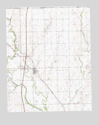
Braman, OK USGS Topographic Map
Click on map above to begin viewing in our Map Viewer.

This topographic map contains these locations and features:
Feature Name Type Latitude Longitude GNIS ID View Map
BramanPopulated PlaceN36.9236°W97.3337°1090451View Map
Braman CemeteryCemeteryN36.9279°W97.3109°1090452View Map
Braman DivisionCivilN36.9436°W97.3047°1937652View Map
Braman Elementary SchoolSchoolN36.9228°W97.3328°1790572View Map
Braman High SchoolSchoolN36.9232°W97.3328°1803847View Map
Braman InterchangeCrossingN36.9270°W97.3487°1101989View Map
Braman Northwest Oil FieldOilfieldN36.9584°W97.3631°1090453View Map
Braman Oil FieldOilfieldN36.9353°W97.3273°1090454View Map
Braman Post OfficePost OfficeN36.9231°W97.3348°1813325View Map
Braman Volunteer Fire DepartmentBuildingN36.9245°W97.3348°2656874View Map
Braman Volunteer Fire Department StorageBuildingN36.9240°W97.3348°2657142View Map
East Bitter CreekStreamN36.9472°W97.2595°470048View Map
First Baptist ChurchChurchN36.9259°W97.3337°1782563View Map
North Braman Oil FieldOilfieldN36.9750°W97.3112°1095918View Map
Oknoname 071002 DamDamN36.9000°W97.3703°1754060View Map
Oknoname 071002 ReservoirReservoirN36.8995°W97.3688°1754061View Map
SumpterPopulated PlaceN36.8836°W97.2945°1100863View Map
Town of BramanCivilN36.9237°W97.3350°2411719View Map
Township of LoweCivilN36.9223°W97.2920°1824809View Map

Note: Coordinates in the location and feature list above are referenced to NAD83 datum.


Copyright (C) 2008-2024 Ryan Niemi / Sunset Dynamics ... All Rights Reserved