TopoQuest Logo
Do you find TopoQuest useful?
Help keep TopoQuest running and adding new maps/features by donating!
Bitcoin:  19c7KJd3qBynnjoSw5npx9KScwjBe4ifkT
Litecoin:  LXs6TkuXGGXo1vDsWCkWVdjQX94eUKd6ui
Home View Maps Find Maps Find Places Resources & Links


Briones Valley, California Topographic Map

USGS Map Title: Briones Valley, CA
USGS Map MRC: 37122H2
DRG (GeoTIFF) Download: o37122h2.tif


Neighboring USGS Topographic Map Quads:


  Mare Island, CA  
38122A3
 

  Benicia, CA  
38122A2
 

  Vine Hill, CA  
38122A1
 

  Richmond, CA  
37122H3
 

  Briones Valley, CA  
37122H2
 

  Walnut Creek, CA  
37122H1
 

  Oakland West, CA  
37122G3
 

  Oakland East, CA  
37122G2
 

  Las Trampas Ridge, CA  
37122G1


Map MRC Location:

N38°
W123°
N38°
W122°
H8 H7 H6 H5 H4 H3 H2 H1
G8 G7 G6 G5 G4 G3 G2 G1
F8 F7 F6 F5 F4 F3 F2 F1
E8 E7 E6 E5 E4 E3 E2 E1
D8 D7 D6 D5 D4 D3 D2 D1
C8 C7 C6 C5 C4 C3 C2 C1
B8 B7 B6 B5 B4 B3 B2 B1
A8 A7 A6 A5 A4 A3 A2 A1
N37°
W123°
N37°
W122°

Briones Valley, CA USGS 1:24K Topographic Map Preview:
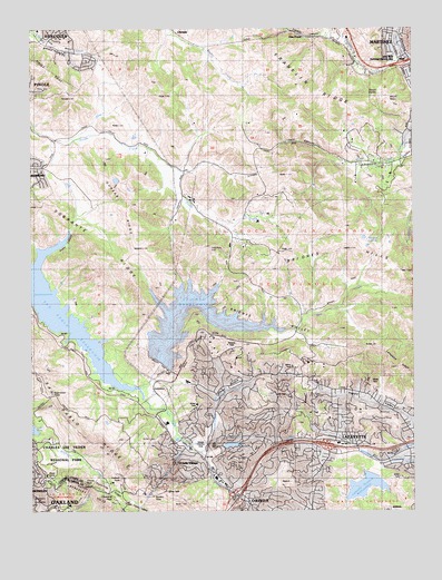
Briones Valley, CA USGS Topographic Map
Click on map above to begin viewing in our Map Viewer.

This topographic map contains these locations and features:
Feature Name Type Latitude Longitude GNIS ID View Map
AcalanesCivilN37.8988°W122.1436°217952View Map
Alhambra CreekStreamN37.9733°W122.1261°218119View Map
Alhambra Valley Census Designated PlaceCensusN37.9666°W122.1319°2582930View Map
Bear CreekStreamN37.9230°W122.1716°218800View Map
Bearinda CoveBayN37.9313°W122.1922°1723559View Map
Berkeley HillsRangeN37.8830°W122.2386°1658038View Map
Black HillsRangeN37.9202°W122.1927°219369View Map
Boy Scout Camp CoveBayN37.9319°W122.1991°1723561View Map
Briones 31-015 DamDamN37.9133°W122.2094°1663402View Map
Briones DamDamN37.9138°W122.2083°219844View Map
Briones DivisionCivilN37.9571°W122.2010°1935031View Map
Briones HillsRangeN37.9430°W122.1466°219845View Map
Briones Regional ParkParkN37.9377°W122.1389°219846View Map
Briones ReservoirReservoirN37.9243°W122.1906°219847View Map
Briones ValleyValleyN37.9138°W122.2083°219848View Map
Briones Valley SchoolSchoolN37.9627°W122.1997°219850View Map
Chaparral PeakSummitN37.8783°W122.2230°1658258View Map
Charles Lee Tilden Regional ParkParkN37.8946°W122.2416°254739View Map
City of OrindaCivilN37.8808°W122.1791°2411334View Map
Claremont Water TunnelTunnelN37.8830°W122.2083°217916View Map
Contra Costa County Fire Protection District Station 16BuildingN37.8953°W122.1524°2624282View Map
Contra Costa County Fire Protection District Station 19BuildingN37.9488°W122.1841°2624451View Map
Cutter CoveBayN37.9202°W122.2022°1723565View Map
Deep CoveBayN37.9277°W122.2077°1723566View Map
East Bay Regional Park District Ambulance Station 1BuildingN37.8823°W122.2249°2662307View Map
East Bay Regional Park District Ambulance Station 6BuildingN37.9633°W122.1408°2662311View Map
Eureka PeakSummitN37.8791°W122.2125°1658514View Map
Exit 10CrossingN37.8917°W122.1714°2107288View Map
Exit 11CrossingN37.8919°W122.1547°2107289View Map
Exit 9CrossingN37.9908°W122.1300°2107266View Map
Exit 9CrossingN37.8789°W122.1844°2107287View Map
Fountainhead Montessori SchoolSchoolN37.8840°W122.1853°253825View Map
Franklin CanyonValleyN37.9971°W122.1522°223812View Map
Franklin CreekStreamN37.9960°W122.1319°223813View Map
Frowning RidgeRidgeN37.8796°W122.2261°223965View Map
Glen FrazerPopulated PlaceN37.9983°W122.1627°1658615View Map
Grizzly PeakSummitN37.8821°W122.2336°1658677View Map
Happy ValleyValleyN37.8985°W122.1269°224904View Map
Happy Valley Elementary SchoolSchoolN37.9049°W122.1424°1723570View Map
Happy Valley Pumping PlantLocaleN37.9089°W122.1819°2339725View Map
Inspiration PointCapeN37.9058°W122.2386°225948View Map
John Muir National Historic SiteParkN37.9828°W122.1326°226274View Map
KALX-FM (Berkeley)TowerN37.8777°W122.2466°1662813View Map
La Boca De Las Caņada Del PinoleCivilN37.9424°W122.1669°255524View Map
Lafayette 31-002 DamDamN37.8849°W122.1394°1663394View Map
Lafayette Police DepartmentBuildingN37.8893°W122.1291°2755734View Map
Lafayette Post OfficePost OfficeN37.8904°W122.1261°2780967View Map
Lafayette ReservoirReservoirN37.8813°W122.1419°226751View Map
Lafayette Water Treatment PlantLocaleN37.8903°W122.1414°2339726View Map
Lafayette Water TunnelTunnelN37.8938°W122.1702°226761View Map
Lake CascadeReservoirN37.8921°W122.1859°220668View Map
Lake Orinda 587 DamDamN37.8916°W122.1877°1663956View Map
Lauterwasser CreekStreamN37.8902°W122.1952°226957View Map
Lawrence Hall of ScienceBuildingN37.8794°W122.2464°1676020View Map
Lawson HillSummitN37.9435°W122.1922°226968View Map
Little John CoveBayN37.9152°W122.2047°1723574View Map
Martinez Post OfficePost OfficeN37.9926°W122.1313°2780976View Map
Moraga - Orinda Fire District Station 43BuildingN37.8996°W122.1704°2624463View Map
Moraga - Orinda Fire District Station 45 HeadquartersBuildingN37.8839°W122.1902°2623865View Map
Mount HelenSummitN37.9816°W122.1333°1675510View Map
Mount WandaSummitN37.9835°W122.1369°1675509View Map
MuirPopulated PlaceN37.9905°W122.1302°1659189View Map
Nike Site SF-09C (historical)MilitaryN37.8889°W122.2219°2087350View Map
OrindaPopulated PlaceN37.8771°W122.1797°1659313View Map
Orinda AcademySchoolN37.8839°W122.1836°230095View Map
Orinda Branch Contra Costa County LibraryBuildingN37.8855°W122.1897°1723581View Map
Orinda Country ClubLocaleN37.8921°W122.1961°1654360View Map
Orinda Police DepartmentBuildingN37.8821°W122.1862°2755804View Map
Orinda Post OfficePost OfficeN37.8828°W122.1900°2781019View Map
Orinda VillagePopulated PlaceN37.8874°W122.1955°1659314View Map
Orinda Water Treatment PlantLocaleN37.8922°W122.2011°2339727View Map
Oursan RidgeRidgeN37.9544°W122.2175°230159View Map
Paul ParkParkN37.8780°W122.1822°1723583View Map
Pereira CoveBayN37.9255°W122.1886°1723584View Map
Pine Grove SchoolSchoolN37.8824°W122.1836°230695View Map
PinoleCivilN37.9905°W122.2333°253757View Map
San Pablo ReservoirReservoirN37.9279°W122.2428°232459View Map
San Pablo RidgeRidgeN37.8837°W122.2219°232460View Map
Sandhill HeliportAirportN37.9210°W122.1964°1653785View Map
Scow CanyonValleyN37.9391°W122.2489°232747View Map
Sindicich LagoonsLakeN37.9435°W122.1410°233172View Map
Sleepy HollowValleyN37.8902°W122.1952°233265View Map
Sleepy Hollow Elementary SchoolSchoolN37.9084°W122.1995°233269View Map
Sobrante RidgeRidgeN37.9419°W122.2308°234814View Map
Sunnyside Pumping PlantLocaleN37.9092°W122.1628°2339729View Map
Temple Isaiah High SchoolSchoolN37.8888°W122.1364°1723590View Map
Tilden Park Golf CourseLocaleN37.8885°W122.2422°1723592View Map
Tin House CoveBayN37.9246°W122.1858°1723593View Map
Vaca CanyonValleyN37.9652°W122.1469°236946View Map
Vallecitos SchoolSchoolN37.8924°W122.1508°236964View Map
Vollmer PeakSummitN37.8833°W122.2219°255204View Map

Note: Coordinates in the location and feature list above are referenced to NAD83 datum.


Copyright (C) 2008-2024 Ryan Niemi / Sunset Dynamics ... All Rights Reserved