TopoQuest Logo
Do you find TopoQuest useful?
Help keep TopoQuest running and adding new maps/features by donating!
Bitcoin:  19c7KJd3qBynnjoSw5npx9KScwjBe4ifkT
Litecoin:  LXs6TkuXGGXo1vDsWCkWVdjQX94eUKd6ui
Home View Maps Find Maps Find Places Resources & Links


Broadwater, Nebraska Topographic Map

USGS Map Title: Broadwater, NE
USGS Map MRC: 41102E7
DRG (GeoTIFF) Download: o41102e7.tif


Neighboring USGS Topographic Map Quads:


  Broadwater NW, NE  
41102F8
 

  Broadwater NE, NE  
41102F7
 

  Tar Valley, NE  
41102F6
 

  Broadwater SW, NE  
41102E8
 

  Broadwater, NE  
41102E7
 

  Tar Valley SW, NE  
41102E6
 

  Dalton, NE  
41102D8
 

  Fairchild Ranch, NE  
41102D7
 

  Lisco NW, NE  
41102D6


Map MRC Location:

N42°
W103°
N42°
W102°
H8 H7 H6 H5 H4 H3 H2 H1
G8 G7 G6 G5 G4 G3 G2 G1
F8 F7 F6 F5 F4 F3 F2 F1
E8 E7 E6 E5 E4 E3 E2 E1
D8 D7 D6 D5 D4 D3 D2 D1
C8 C7 C6 C5 C4 C3 C2 C1
B8 B7 B6 B5 B4 B3 B2 B1
A8 A7 A6 A5 A4 A3 A2 A1
N41°
W103°
N41°
W102°

Broadwater, NE USGS 1:24K Topographic Map Preview:
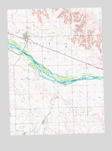
Broadwater, NE USGS Topographic Map
Click on map above to begin viewing in our Map Viewer.

This topographic map contains these locations and features:
Feature Name Type Latitude Longitude GNIS ID View Map
Ag Air AirportAirportN41.5965°W102.8182°837503View Map
Ancient Bluff RuinsCliffN41.5861°W102.7671°1830001View Map
Beerline CanalCanalN41.6019°W102.8580°827288View Map
BroadwaterPopulated PlaceN41.5961°W102.8527°827657View Map
BroadwaterLocaleN41.5961°W102.8527°1829985View Map
Broadwater Election PrecinctCivilN41.5869°W102.7797°1928753View Map
Broadwater Post OfficePost OfficeN41.5970°W102.8536°1829984View Map
Broadwater Public LibraryBuildingN41.5961°W102.8527°1829983View Map
Broadwater Public SchoolSchoolN41.5978°W102.8505°1829986View Map
Broadwater Volunteer Fire DepartmentBuildingN41.5964°W102.8517°2553375View Map
Cedar CreekStreamN41.5516°W102.8113°827995View Map
EastwoodLocaleN41.5708°W102.7774°1829981View Map
Finley (historical)LocaleN41.5644°W102.7566°1829936View Map
Messiah Lutheran ChurchChurchN41.5961°W102.8527°1829982View Map
Narcissa Whitman Historical MarkerParkN41.5675°W102.7616°1830002View Map
Radcliff Number 3 CanalCanalN41.5094°W102.8263°836095View Map
Radcliffe CanalCanalN41.5100°W102.8408°832435View Map
Rose Hill CemeteryCemeteryN41.6063°W102.8488°832693View Map
Silverthorn CemeteryCemeteryN41.5265°W102.7535°833454View Map
Village of BroadwaterCivilN41.5979°W102.8524°2397461View Map

Note: Coordinates in the location and feature list above are referenced to NAD83 datum.


Copyright (C) 2008-2025 Ryan Niemi / Sunset Dynamics ... All Rights Reserved