TopoQuest Logo
Do you find TopoQuest useful?
Help keep TopoQuest running and adding new maps/features by donating!
Bitcoin:  19c7KJd3qBynnjoSw5npx9KScwjBe4ifkT
Litecoin:  LXs6TkuXGGXo1vDsWCkWVdjQX94eUKd6ui
Home View Maps Find Maps Find Places Resources & Links


Brookville, Illinois Topographic Map

USGS Map Title: Brookville, IL
USGS Map MRC: 42089A6
DRG (GeoTIFF) Download: o42089a6.tif


Neighboring USGS Topographic Map Quads:


  Boone Branch, IL  
42089B7
 

  Shannon, IL  
42089B6
 

  Forreston North, IL  
42089B5
 

  Lanark, IL  
42089A7
 

  Brookville, IL  
42089A6
 

  Forreston South, IL  
42089A5
 

  Milledgeville, IL  
41089H7
 

  Hazelhurst, IL  
41089H6
 

  Polo, IL  
41089H5


Map MRC Location:

N43°
W90°
N43°
W89°
H8 H7 H6 H5 H4 H3 H2 H1
G8 G7 G6 G5 G4 G3 G2 G1
F8 F7 F6 F5 F4 F3 F2 F1
E8 E7 E6 E5 E4 E3 E2 E1
D8 D7 D6 D5 D4 D3 D2 D1
C8 C7 C6 C5 C4 C3 C2 C1
B8 B7 B6 B5 B4 B3 B2 B1
A8 A7 A6 A5 A4 A3 A2 A1
N42°
W90°
N42°
W89°

Brookville, IL USGS 1:24K Topographic Map Preview:
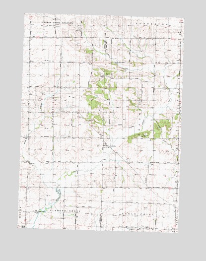
Brookville, IL USGS Topographic Map
Click on map above to begin viewing in our Map Viewer.

This topographic map contains these locations and features:
Feature Name Type Latitude Longitude GNIS ID View Map
BrookvillePopulated PlaceN42.0486°W89.6840°404924View Map
Brookville Lutheran CemeteryCemeteryN42.0550°W89.6873°1785402View Map
Brookville Lutheran Cemetery Prairie Nature PreserveParkN42.0550°W89.6873°2013471View Map
Brookville QuarryMineN42.0639°W89.6954°1983527View Map
Brookville Township CemeteryCemeteryN42.0453°W89.6759°1808189View Map
Burr Oak School (historical)SchoolN42.0464°W89.6471°405263View Map
Canada School (historical)SchoolN42.0248°W89.6262°405543View Map
Chambers Grove CemeteryCemeteryN42.0897°W89.6840°1808201View Map
Chambers Grove School (historical)SchoolN42.0892°W89.6865°405931View Map
Cowen School (historical)SchoolN42.0378°W89.7248°406683View Map
Elkhorn GrovePopulated PlaceN42.0081°W89.7346°422663View Map
Fivemile CreekStreamN42.0661°W89.6479°408422View Map
Folkers FarmLocaleN42.0031°W89.6336°2680883View Map
Forreston Grove CemeteryCemeteryN42.1164°W89.6284°1808227View Map
Forreston Grove ChurchChurchN42.1164°W89.6279°1705912View Map
Genter Hill School (historical)SchoolN42.0789°W89.6479°408943View Map
Good School (historical)SchoolN42.0956°W89.7215°409142View Map
Goose HollowValleyN42.0404°W89.6815°409168View Map
Middle CreekStreamN42.0236°W89.7204°413483View Map
Middle Creek Church (historical)ChurchN42.0375°W89.7426°413493View Map
Miller School (historical)SchoolN42.0634°W89.7237°413603View Map
Mount Vernon School (historical)SchoolN42.1011°W89.6459°414103View Map
Rock River CampLocaleN42.0561°W89.6554°1705911View Map
Schriner CemeteryCemeteryN42.0375°W89.7429°1785446View Map
Stewart School (historical)SchoolN42.0120°W89.6862°419132View Map
Township of BrookvilleCivilN42.0689°W89.6563°428717View Map
West Fork Elkhorn CreekStreamN42.0861°W89.6368°420830View Map

Note: Coordinates in the location and feature list above are referenced to NAD83 datum.


Copyright (C) 2008-2025 Ryan Niemi / Sunset Dynamics ... All Rights Reserved