TopoQuest Logo
Do you find TopoQuest useful?
Help keep TopoQuest running and adding new maps/features by donating!
Bitcoin:  19c7KJd3qBynnjoSw5npx9KScwjBe4ifkT
Litecoin:  LXs6TkuXGGXo1vDsWCkWVdjQX94eUKd6ui
Home View Maps Find Maps Find Places Resources & Links


Bryan West, Texas Topographic Map

USGS Map Title: Bryan West, TX
USGS Map MRC: 30096F4
DRG (GeoTIFF) Download: o30096f4.tif


Neighboring USGS Topographic Map Quads:


  Hearne South, TX  
30096G5
 

  Dunn Creek, TX  
30096G4
 

  Kurten, TX  
30096G3
 

  Mumford, TX  
30096F5
 

  Bryan West, TX  
30096F4
 

  Bryan East, TX  
30096F3
 

  Tunis, TX  
30096E5
 

  Chances Store, TX  
30096E4
 

  Wellborn, TX  
30096E3


Map MRC Location:

N31°
W97°
N31°
W96°
H8 H7 H6 H5 H4 H3 H2 H1
G8 G7 G6 G5 G4 G3 G2 G1
F8 F7 F6 F5 F4 F3 F2 F1
E8 E7 E6 E5 E4 E3 E2 E1
D8 D7 D6 D5 D4 D3 D2 D1
C8 C7 C6 C5 C4 C3 C2 C1
B8 B7 B6 B5 B4 B3 B2 B1
A8 A7 A6 A5 A4 A3 A2 A1
N30°
W97°
N30°
W96°

Bryan West, TX USGS 1:24K Topographic Map Preview:
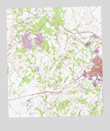
Bryan West, TX USGS Topographic Map
Click on map above to begin viewing in our Map Viewer.

This topographic map contains these locations and features:
Feature Name Type Latitude Longitude GNIS ID View Map
Anson Jones Junior High SchoolSchoolN30.6641°W96.3850°1351134View Map
BenchleyPopulated PlaceN30.7485°W96.4586°1351871View Map
Blackjack Volunteer Fire Department Station 2BuildingN30.7487°W96.4605°2552509View Map
Bonham Elementary SchoolSchoolN30.7044°W96.3800°2003416View Map
Bonham ParkParkN30.7010°W96.3802°2028762View Map
Bonham SchoolSchoolN30.7069°W96.3755°1352656View Map
Bowie SchoolSchoolN30.6738°W96.3769°1352745View Map
Brazos County Detention CenterBuildingN30.6782°W96.3946°2738754View Map
Brazos County Precinct 4 Fire Department Station 2BuildingN30.7290°W96.4741°2552171View Map
Brazos County Precinct 4 Volunteer Fire Department Station 1BuildingN30.6514°W96.4931°2552276View Map
Brazos County Sheriff's OfficeBuildingN30.6763°W96.3932°2739362View Map
Bryan Air Force Base (historical)MilitaryN30.6372°W96.4792°2090304View Map
Bryan Fire Department Station 1BuildingN30.6754°W96.3755°2552661View Map
Bryan Fire Department Station 4BuildingN30.7144°W96.4081°2552430View Map
Bryan Ice HouseBuildingN30.6741°W96.3780°2031455View Map
Bryan Utilities LakeReservoirN30.7085°W96.4519°1857929View Map
Bryan Utilities Lake DamDamN30.7085°W96.4519°1857928View Map
Canaan CemeteryCemeteryN30.6388°W96.4997°1353713View Map
Carver SchoolSchoolN30.6855°W96.3861°1353907View Map
Cottonwood BranchStreamN30.6521°W96.4416°1355051View Map
Dobrovolny LakeReservoirN30.6610°W96.4467°1857925View Map
Dobrovolny Lake DamDamN30.6602°W96.4469°1857924View Map
Doctor William Holt Oliver HouseBuildingN30.6746°W96.3789°2031298View Map
E J Blazek HouseBuildingN30.6702°W96.3775°2031252View Map
Elm CreekStreamN30.7349°W96.4727°1356949View Map
English-Poindexter HouseBuildingN30.6724°W96.3752°2031245View Map
FairviewPopulated PlaceN30.6521°W96.4352°1357171View Map
FountainPopulated PlaceN30.6724°W96.4839°1379793View Map
Gilmore CemeteryCemeteryN30.7202°W96.4336°1358034View Map
Goodson CemeteryCemeteryN30.6291°W96.4655°1358171View Map
Griesser Bakery and CSPS LodgeBuildingN30.6766°W96.3780°2031146View Map
Henderson ParkParkN30.6571°W96.3839°2029197View Map
Henry CemeteryCemeteryN30.6852°W96.4169°1359042View Map
James O Chance HouseBuildingN30.6738°W96.3755°2030951View Map
Jane Long Middle SchoolSchoolN30.6449°W96.3905°2003391View Map
Jones Elementary Magnet SchoolSchoolN30.6638°W96.3850°2003393View Map
Kemp High SchoolSchoolN30.6794°W96.3791°1360558View Map
Lake Bryan Census Designated PlaceCensusN30.7188°W96.4631°2586943View Map
Lake Bryan TrailTrailN30.7099°W96.4650°2033487View Map
Lake MaryReservoirN30.6690°W96.4467°1362246View Map
Leisure LakeReservoirN30.6350°W96.4114°1857927View Map
Leisure Lake DamDamN30.6335°W96.4119°1857926View Map
Lobo Stadium - Jane Long Middle SchoolParkN30.6527°W96.3955°2027779View Map
Mary Branch Elementary SchoolSchoolN30.6288°W96.3797°2003396View Map
Milam Elementary SchoolSchoolN30.6641°W96.3830°2003397View Map
Milam SchoolSchoolN30.6624°W96.3816°1362825View Map
Milton Parker HouseBuildingN30.6733°W96.3808°2030712View Map
Mount Tiver ChurchChurchN30.7294°W96.4911°1363325View Map
Navarro Elementary SchoolSchoolN30.7160°W96.3919°2003398View Map
Pleasant Hill ChurchChurchN30.6713°W96.4366°1365428View Map
R Q Astin HouseBuildingN30.6746°W96.3780°2031723View Map
Red Hill CemeteryCemeteryN30.6805°W96.4330°1366159View Map
Rest-Ever Memorial CemeteryCemeteryN30.7135°W96.4033°1366371View Map
RyePopulated PlaceN30.7294°W96.4902°1380474View Map
Saint Anthonys Catholic ChurchChurchN30.6713°W96.3758°2032230View Map
Santa Teresa ChurchChurchN30.6777°W96.3852°1367762View Map
Sausley HouseBuildingN30.6794°W96.3791°2032631View Map
Scurry ParkParkN30.6905°W96.3791°2029390View Map
SmetanaPopulated PlaceN30.6521°W96.4572°1388219View Map
Smith LakeReservoirN30.6652°W96.4251°1857931View Map
Smith Lake DamDamN30.6635°W96.4252°1857930View Map
Smith-Barron HouseBuildingN30.6741°W96.3805°2032619View Map
Still CreekStreamN30.6491°W96.4489°1369203View Map
Texas A & M Flight Test Station AirportAirportN30.6311°W96.4794°1386309View Map
Texas A and M University Research AnnexSchoolN30.6391°W96.4725°1376419View Map
Texas Department of Criminal Justice J W Hamilton UnitBuildingN30.6905°W96.4196°2738620View Map
Thompsons BranchStreamN30.6899°W96.4327°1369859View Map
West Brazos DivisionCivilN30.6580°W96.4676°1939312View Map

Note: Coordinates in the location and feature list above are referenced to NAD83 datum.


Copyright (C) 2008-2025 Ryan Niemi / Sunset Dynamics ... All Rights Reserved