TopoQuest Logo
Do you find TopoQuest useful?
Help keep TopoQuest running and adding new maps/features by donating!
Bitcoin:  19c7KJd3qBynnjoSw5npx9KScwjBe4ifkT
Litecoin:  LXs6TkuXGGXo1vDsWCkWVdjQX94eUKd6ui
Home View Maps Find Maps Find Places Resources & Links


Buckeye, Colorado Topographic Map

USGS Map Title: Buckeye, CO
USGS Map MRC: 40105G1
DRG (GeoTIFF) Download: o40105g1.tif


Neighboring USGS Topographic Map Quads:


  Table Mountain, CO  
40105H2
 

  Round Butte, CO  
40105H1
 

  Carr West, CO  
40104H8
 

  Livermore, CO  
40105G2
 

  Buckeye, CO  
40105G1
 

  Carr SW, CO  
40104G8
 

  Laporte, CO  
40105F2
 

  Wellington, CO  
40105F1
 

  Cobb Lake, CO  
40104F8


Map MRC Location:

N41°
W106°
N41°
W105°
H8 H7 H6 H5 H4 H3 H2 H1
G8 G7 G6 G5 G4 G3 G2 G1
F8 F7 F6 F5 F4 F3 F2 F1
E8 E7 E6 E5 E4 E3 E2 E1
D8 D7 D6 D5 D4 D3 D2 D1
C8 C7 C6 C5 C4 C3 C2 C1
B8 B7 B6 B5 B4 B3 B2 B1
A8 A7 A6 A5 A4 A3 A2 A1
N40°
W106°
N40°
W105°

Buckeye, CO USGS 1:24K Topographic Map Preview:
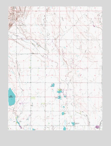
Buckeye, CO USGS Topographic Map
Click on map above to begin viewing in our Map Viewer.

This topographic map contains these locations and features:
Feature Name Type Latitude Longitude GNIS ID View Map
Barrett DamDamN40.7733°W105.0505°198406View Map
Barrett ReservoirReservoirN40.7737°W105.0514°198407View Map
Box Elder Number 1 DamDamN40.7876°W105.0577°198410View Map
Box Elder Number 5 DamDamN40.7833°W105.0489°201008View Map
Box Elder Reservoir Number 5ReservoirN40.7842°W105.0497°201009View Map
Box I Number 1 DamDamN40.7950°W105.0639°198408View Map
Box I Reservoir Number 1ReservoirN40.7955°W105.0656°198409View Map
Boxelder Reservoir Number 1ReservoirN40.7889°W105.0570°172458View Map
Boxelder Reservoir Number TwoReservoirN40.7833°W105.0571°201301View Map
Bubbles LakeReservoirN40.7670°W105.0523°200295View Map
BuckeyePopulated PlaceN40.8272°W105.0950°172460View Map
Buckeye LateralCanalN40.8061°W105.0950°172455View Map
Buckeye Ranch CemeteryCemeteryN40.8369°W105.0850°2036980View Map
Gilman MountainSummitN40.8736°W105.1175°201972View Map
Martin Seepage Number 2 DamDamN40.7566°W105.1105°198436View Map
Martin Seepage Reservoir Number 2ReservoirN40.7584°W105.1121°198437View Map
Mountain Supply Number 7 DamDamN40.7666°W105.0522°200294View Map
North Poudre Number 11 DamDamN40.7566°W105.0372°201310View Map
North Poudre Number 15 DamDamN40.7766°W105.1222°199708View Map
North Poudre Reservoir Number 11ReservoirN40.7568°W105.0388°201311View Map
North Poudre Reservoir Number 15ReservoirN40.7830°W105.1207°199709View Map
Park Creek LateralCanalN40.8166°W105.1111°201901View Map
Rawhide CreekStreamN40.8236°W105.0739°171106View Map
RippleLocaleN40.7750°W105.0950°172456View Map
Sheep Draw QuarryMineN40.8355°W105.1133°1683371View Map
Timnath-Wellington DivisionCivilN40.8292°W105.0953°1935583View Map
Wasson ReservoirReservoirN40.7516°W105.0502°198459View Map
Wellington Oil FieldOilfieldN40.7750°W105.0478°172454View Map
Wire DrawValleyN40.8626°W105.0759°201973View Map

Note: Coordinates in the location and feature list above are referenced to NAD83 datum.


Copyright (C) 2008-2025 Ryan Niemi / Sunset Dynamics ... All Rights Reserved