TopoQuest Logo
Do you find TopoQuest useful?
Help keep TopoQuest running and adding new maps/features by donating!
Bitcoin:  19c7KJd3qBynnjoSw5npx9KScwjBe4ifkT
Litecoin:  LXs6TkuXGGXo1vDsWCkWVdjQX94eUKd6ui
Home View Maps Find Maps Find Places Resources & Links


Buell Park, Arizona Topographic Map

USGS Map Title: Buell Park, AZ
USGS Map MRC: 35109H1
DRG (GeoTIFF) Download: o35109h1.tif


Neighboring USGS Topographic Map Quads:


  White Clay, AZ  
36109A2
 

  Sonsela Buttes, AZ  
36109A1
 

  Crystal, NM  
36108A8
 

  Sawmill, AZ  
35109H2
 

  Buell Park, AZ  
35109H1
 

  Todilto Park, NM  
35108H8
 

  Piney Hill, AZ  
35109G2
 

  Fort Defiance, AZ  
35109G1
 

  Crevasse Canyon, NM  
35108G8


Map MRC Location:

N36°
W110°
N36°
W109°
H8 H7 H6 H5 H4 H3 H2 H1
G8 G7 G6 G5 G4 G3 G2 G1
F8 F7 F6 F5 F4 F3 F2 F1
E8 E7 E6 E5 E4 E3 E2 E1
D8 D7 D6 D5 D4 D3 D2 D1
C8 C7 C6 C5 C4 C3 C2 C1
B8 B7 B6 B5 B4 B3 B2 B1
A8 A7 A6 A5 A4 A3 A2 A1
N35°
W110°
N35°
W109°

Buell Park, AZ USGS 1:24K Topographic Map Preview:
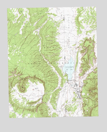
Buell Park, AZ USGS Topographic Map
Click on map above to begin viewing in our Map Viewer.

This topographic map contains these locations and features:
Feature Name Type Latitude Longitude GNIS ID View Map
Buell MountainSummitN35.9192°W109.1040°2124View Map
Buell ParkFlatN35.9000°W109.0973°2125View Map
Frog RockPillarN35.9097°W109.0256°898315View Map
Green KnobsSummitN35.9533°W109.0287°899656View Map
Justins WindmillWellN35.9986°W109.0557°21672View Map
NavajoPopulated PlaceN35.9000°W109.0340°933101View Map
Navajo Census Designated PlaceCensusN35.9024°W109.0321°2408904View Map
Navajo Community LibraryBuildingN35.9000°W109.0340°929409View Map
Navajo Elementary SchoolSchoolN35.9000°W109.0340°933917View Map
Navajo Pine Volunteer Fire and RescueBuildingN35.9073°W109.0306°2657701View Map
Outlet NeckPillarN35.9136°W109.0409°892975View Map
Outlet NeckRidgeN35.9147°W109.0509°9036View Map
Peridot RidgeRidgeN35.8922°W109.0890°9329View Map
Red LakeReservoirN35.9284°W109.0409°10081View Map
Red Lake ChapterCivilN35.8835°W109.0384°2419069View Map
Red Lake Chapter HouseBuildingN35.9070°W109.0495°21760View Map
Red Lake DamDamN35.9167°W109.0390°923917View Map
Red Lake DamDamN35.9167°W109.0340°21761View Map
Red Lake Natural BridgeArchN35.9283°W109.0233°2632187View Map
Red ValleyValleyN35.9156°W109.0301°897454View Map
Red ValleyValleyN35.9156°W109.0301°10172View Map
Split MesaSummitN35.9592°W109.0126°899924View Map
Sterrett MesaSummitN35.9097°W109.1079°11829View Map
Tohdildonih WashStreamN35.9083°W109.0437°897491View Map
Zilditloi MountainSummitN35.9033°W109.0070°902856View Map
Zilditloi WashStreamN35.9070°W109.0279°896848View Map

Note: Coordinates in the location and feature list above are referenced to NAD83 datum.


Copyright (C) 2008-2024 Ryan Niemi / Sunset Dynamics ... All Rights Reserved